- Mullum Mullum Creek Trail
-
Mullum Mullum Creek Trail through Yarran Dheran Mullum Mullum Creek Trail Length Upper 5.4km, lower 7.8km Difficulty Easy Hills Undulating Hazards Horses Connecting Transport Train Ringwood station The Mullum Mullum Creek Trail is a shared use path for cyclists and pedestrians, which follows Mullum Mullum Creek in the outer eastern suburbs in Melbourne, Victoria, Australia.[1][2][3]
The path is currently split into two sections, which will be linked to form one continuous trail from Templestowe to Croydon. Until this link is constructed, the two sections of the path between the end of the Yarra River Trail in Templestowe and Tindals Road in Donvale is the lower section, while the section between the end of the Koonung Creek Trail in Donvale and Highland Avenue in Croydon is the upper section. The missing section is currently being constructed in two parts. The section between Tindals Road and Park Road in Donvale is currently under construction and was set to open in 2009[4], but as of July 2011 it is yet to be completed. The section between Park Road and the end of the Koonung Creek Trail in Donvale will be constructed in the future, with a detail planning study having been completed[5].
Following the Path
Upper section
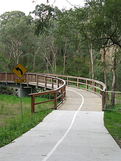
The upper section starts in the east at the end of Highland Ave. The path heads in a south westerly direction, with at-level road crossing at Kalinda Road, Oban Road, and Oliver Street. Before the tunnel under the Ringwood Bypass, there is a turnoff to the Belgrave Rail Trail, which initially runs on-road along Suda Avenue and Samuel Street. The trail then heads under the tunnel and takes an immediate right turn west towards Eastland Shopping Centre. A road crossing at Warrandyte Road and a tunnel under Ringwood Street sends you to the end of the EastLink Trail. Continuing under the EastLink onramps leads you under Deep Creek Road and into Yarran Dheran. The path continues north west past sensitive flora and fauna by the concrete path mixed with a series of timber bridges and boardwalks. An at-level crossing with Quarry Road is confronted before continuing west. The track ends at a currently unsigned future extension of the Mullum Mullum Creek Trail 80m west of Beckett Road. At this point, the path seamlessly becomes the Koonung Creek Trail, which takes users towards Doncaster and eventually the Melbourne CBD along the Eastern Freeway. Refer also to Mullum Mullum Creek and Mullum Mullum Creek Park
Central Section - currently under construction or in the planning stage @Dec 2010
The central section which is the 'missing link' of the whole Mullum Mullum Creek Trail is actually in 2 parts. The section currently under construction runs from Park Road north to Tindals Road (~1.7km) and the final section, still only in the planning stages, from Park Road south to join the Eastlink Trail (~2.5km). When these last 2 sections are complete you will be able to ride from Ringwood/Mitcham and (heading north) along the Mullum Mullum Trail join the Main Yarra Trail at Templestowe. NB. As of late July 2010 works on the Park Rd.-Tindals Rd. section appear to have stalled with little if any work having been carried out over the past 12+months. All trail/bridge works have been completed through council 'owned' land with the works stalling where the land becomes privately owned and awaiting the outcome of a development application.
Current progress of trail works: So far, heading north from Park Rd. a small carpark, an ashphalted 2metre wide trail(~1km) and 2 bridges have been completed but the works stop short about 700m from Tindals Rd. (NB. There is no access through to Tindals Rd.) Foundations works on the southern side of Park Rd. for the trail bridge over the Mullum Mullum Creek also appear under construction.
Lower section
The lower section starts at Tindals Road and continues 1.4 km to just before Reynolds Road. The path splits here; take the left track. Continuing though a heavily treed area, the path crosses Heidelberg - Warrandyte Road. On the far side is a wooden bridge and boardwalk - continue to the left - the right leads to a tea house at Beasley's Nursery.
After 1.1 km the path opens up into a more open area and meets the Greengully Trail that enters from the left (south). The intersection is badly signed. Continue past large open areas on the right (east) where Kangaroos/Wallabies can be seen on a regular basis, just 20 km from the Melbourne CBD.
The trail finally ends at the confluence of the Mullum Mullum Creek and the Yarra River in Templestowe. A lookout surveys the spot. The Yarra River Trail starts here.
Connections
The south western end of the upper section connects to the Belgrave Rail Trail. The north eastern end of the upper section finishes at Cherry Tree Grv. From Cherry Grv, a 2.7 km road section, via Croydon station, can be used to reach the Tarralla Creek Trail. A Maroondah Council project "Lake to Creek Link Project"[6] will, once completed, improve the link to Ringwood Lake and the Belgrave Rail Trail beyond.
The northern end of the lower section connects to the Yarra River Trail. The path also connects to the Greengully Trail 1.2 km south of the Yarra. The southern end of the lower section terminates at Tindals Rd.
Upper: West end at 37°48′15″S 145°12′16″E / 37.804200°S 145.204411°E. East end at 37°47′07″S 145°15′51″E / 37.785142°S 145.264044°E.
Lower: North end at 37°44′18″S 145°09′43″E / 37.738386°S 145.161994°E. South end at 37°46′32″S 145°11′26″E / 37.775679°S 145.190680°E.References
- Manningham Leader - grant
- Bike rides around Melbourne 3rd edition, 2009, Julia Blunden, Open Spaces Publishing, ISBN 978-0-9752333-4-4
- Bike Paths Victoria sixth edition, 2004. Edited and published by Sabey & Associates Pty Ltd. pp127. ISBN 0957959117
External links
Categories:

Wikimedia Foundation. 2010.