- Chivi District
-
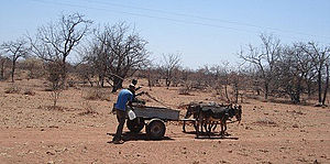
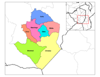
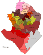
Chivi — District — Typical mode of transport across the district. Districts of Masvingo province Masvingo constituency seats for the 2008, showing the division of Chivi (District) Coordinates: 20°05′S 31°37′E / 20.083°S 31.617°ECoordinates: 20°05′S 31°37′E / 20.083°S 31.617°E Country Zimbabwe Province Masvingo District Chivi 19th century Government – Type Rural Council – Member of Parliament Col. Claudious Makova, Time zone CAT (UTC+2) – Summer (DST) CEST (UTC+1) Chivi a district in Masvingo Province in Zimbabwe. It is a semi-arid area which falls in agricultural regions 4 and 5. It is also the name of a mission station established in 1892 by Wedpohl, Neitz and Dietrich from Berlin, Germany. The district was known as Chibi in colonial times before 1980.
Contents
Geography
The district is located in the dry prone region of the country, north of Mwenezi (District) and west of Masvingo (District). Consequently, like most districts in the province. Though the rains are not very reliable, the area is fertile with several irrigation schemes for the populance to supplement their mearge harvests.However the schemes are now in sorry state due to government neglecet. There is ranching and wildlife which make life enjoyable and fruitful. It has many schools and noteworthy are Mission schools like Chibi High, Berejena Mission and other smaller schools which have produced brilliant students such as Arch Munaka. One graduate from this rural secondary school, Joshua Foromera is currently pursuing a degree in Neuroscience at Duke University in North Carolina, United States. It is also important to note that Chibi High School produced many students who managed to enroll in state universities around the country and some of these students are occupying high jobs in the industry and some are distinguished academic scholars.[1]
Government & politics
The district sends three members to Zimbabwe's House of Assembly. Each of the wards in the district has on elected official who works at the rural district council.
The district was divided into three sections for the 2008 elections, namely east, west and south. The district has been a stronghold of ZANU-PF since independence in 1980. All that changed in the elections of 2008 with the opposition led by Morgan Tsvangirai winning all the three seats, one with a razor thin margin.[2][3]
Chivi South
Chivi south is made of wards 1, 19, 22, 23, 24, 25, 26, 27, 28, 29, and 32. During the 2008 House of Assembly elections, Irvine Dzingirai(ZANU-PF), and Steven Chengeta (MDC(tsv)) ran for the seat. ZEC announced Dzingirai as the winner with a total of 7778 to 4234 of Chengeta.
The MP for Chivi Central is Munyarazi Paul Mangwana(Zanu Pf). He comes from Mangwana Village just 5km from the Chivi Growth Point.
Chivi Central
Bikita East comprises wards 14, 15, 16, 17, 18, 20, 21, 24, 25, and 27. Paul Mangwana(ZANU-PF), and Henry Chivanga (MDC(tsv)) ran for the seat for the house of assembly. According to ZEC, Mangwana won the seat with 8228 votes to 6471 polled by Chivanga.
Chivi North
The cosntituency seat is made up of eleven ward, namely 5, 9, 10, 11, 12, 13, 16, 22, 23, and 32.
References
Masvingo Province Business Centres Towns & Cities Districts Noteworthy Places Subdivisions of Zimbabwe Provinces Districts Beitbridge · Bikita · Bindura · Binga · Bubi · Buhera · Bulawayo · Bulilimamangwe · Chegutu · Chikomba · Chimanimani · Chipinge · Chiredzi · Chirumhanzu · Chivi · Gokwe North · Gokwe South · Goromonzi · Guruve · Gutu · Gwanda · Gweru · Harare · Hurungwe · Hwange · Hwedza · Insiza · Kadoma · Kariba · Kwekwe · Lupane · Makonde · Makoni · Marondera · Masvingo · Matobo · Mazowe · Mberengwa · Mount Darwin · Mudzi · Mukumbura · Murehwa · Mutare · Mutasa · Mutoko · Muzarabani · Mwenezi · Nkayi · Nyanga · Rushinga · Seke · Shamva · Shurugwi · Tsholotsho · Umguza · Umzingwane · Uzumba-Maramba-Pfungwe · Wedza · Zaka · Zvimba · ZvishavaneWards Largest cities Categories:- Chivi District
- Districts of Masvingo Province
- Zimbabwe geography stubs
Wikimedia Foundation. 2010.


