- Gutu District
Infobox Settlement
name = Gutu
official_name =
other_name =
native_name =
nickname =
settlement_type =District
total_type =
motto =

imagesize =300px
image_caption =Typical mode of transport across the district.
flag_size =
image_
seal_size =
image_shield =
shield_size =
image_blank_emblem =
blank_emblem_type =
blank_emblem_size =
mapsize = 160px
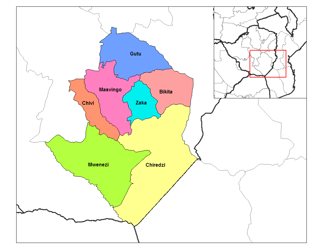
map_caption = Districts ofMasvingo Province
mapsize1 = 150px
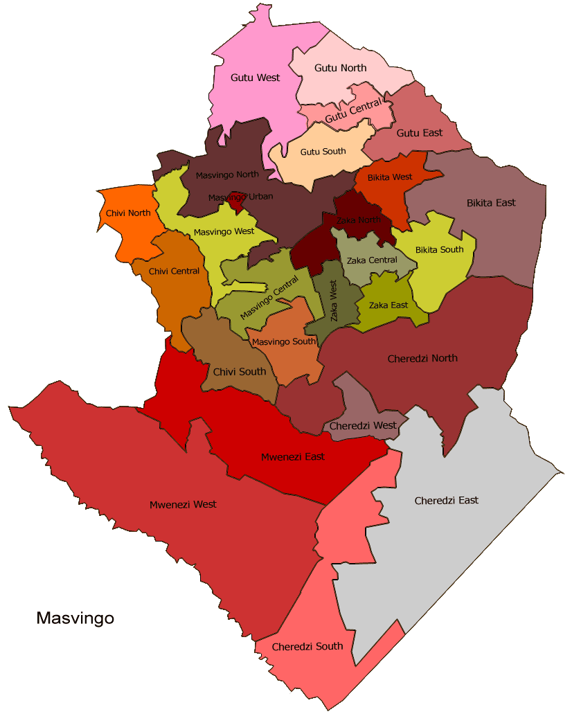
map_caption1 =Masvingo constituency seats for the 2008, showing the division of Chivi (District)
image_dot_
dot_mapsize =
dot_map_caption =
dot_x = |dot_y =
pushpin_
pushpin_label_position =
pushpin_map_caption =
pushpin_mapsize = 150
subdivision_type =Country
subdivision_name =Zimbabwe
subdivision_type1 = Province
subdivision_name1 = Masvingo
subdivision_type2 = District
subdivision_name2 = Gutu
subdivision_type3 =
subdivision_name3 =
subdivision_type4 =
subdivision_name4 =
government_footnotes =
government_type =
leader_title =
leader_name =
leader_title1 =
leader_name1 =
leader_title2 =
leader_name2 =
leader_title3 =
leader_name3 =
leader_title4 =
leader_name4 =
established_title = Established
established_date = late19th Century
established_title2 =
established_date2 =
established_title3 =
established_date3 =
area_magnitude =
unit_pref =
area_footnotes =
area_total_km2 =
area_land_km2 =
area_water_km2 =
area_total_sq_mi =
area_land_sq_mi =
area_water_sq_mi =
area_water_percent =
area_urban_km2 =
area_urban_sq_mi =
area_metro_km2 =
area_metro_sq_mi =
area_blank1_title =
area_blank1_km2 =
area_blank1_sq_mi =
population_as_of =2002
population_footnotes =
population_note = estimate (UN )
population_total =198 000
population_density_km2 =22.08
population_density_sq_mi =
population_metro =
population_density_metro_km2 =
population_density_metro_sq_mi =
population_urban =
population_density_urban_km2 =
population_density_urban_sq_mi =
population_blank1_title =
population_blank1 =
population_density_blank1_km2 =
population_density_blank1_sq_mi =
timezone = CET
utc_offset = +1
timezone_DST = CEST
utc_offset_DST = +1
elevation_footnotes =
elevation_m =
elevation_ft =
postal_code_type =
postal_code =
area_code =
blank_name =
blank_info =
blank1_name =
blank1_info =
website =
footnotes =Gutu is a small district in
Masvingo Province , southernZimbabwe . It is the the northernmost district in the province.Mupandawana is the district service centre, it was designated as a "growth point" during the early years of independentZimbabwe together with such places asGokwe in theMidlands Province and Juru inMashonaland East province.It is was home to
Simon Muzenda , the former vice president of Zimbabwe.Gutu Mission Hospital found in the district, is one of a numbers of center forHIV /AIDS treatment in the province. [AIDS treament centers [http://www.zan.co.zw/newsflash_view.cfm?nfid=12] (accessed 02/18/2008)] The population is mostly theKaranga , aShona sub-tribe. It is one of a few districts in the province where the standard of living is above average. Gutu Rural District council is in charge of the day to day running of the district.Geography
Climatically, the area falls under Natural Region III. Natural Regions (NRs) in Zimbabwe's context are areas delineated on the basis of soil type, rainfall and other climatic factors. [CSO, 1997, 144 [http://www.sciencedirect.com/science?_ob=ArticleURL&_udi=B6V7K-4GG2J64-1&_user=1458830&_rdoc=1&_fmt=&_orig=search&_sort=d&view=c&_acct=C000052790&_version=1&_urlVersion=0&_userid=1458830&md5=0cfaa99bf92e66711bf74acd3d572f96#bib14] ] It is one of a few districts in the country that suffers from over-population. It's population density of 22.08 per square kilometer is among the highest in the country. [Land Use in Gutu [http://www.sciencedirect.com/science?_ob=ArticleURL&_udi=B6V7K-4GG2J64-1&_user=1458830&_rdoc=1&_fmt=&_orig=search&_sort=d&view=c&_acct=C000052790&_version=1&_urlVersion=0&_userid=1458830&md5=0cfaa99bf92e66711bf74acd3d572f96] ] Gutu district center had a population of 10-12000 in 1989. Like other districts in the country, medical facilities in the district suffer from shortage of manpower. [Zimbabwe Brain Drain [http://allafrica.com/stories/200306090504.html] (accessed 02/18/2008)]
Mpandawana Growth Point, a famous business center in Zimbabwe, is found in the district. [Gutu RDC offered 1billion [http://allafrica.com/stories/200708130648.html] (accessed 02/18/2008)]
Government & Politics
General Elections 2008
The district was divided into four parts by the electoral commission for the general elections of 2008. Candidates from both the
MDC andZANU-PF and independents will compete for the four constituency seats available and winner will go one to represent the district inZimbabwe 's newHouse of Assembly .Matuke Lovemore (
Zanu-PF ), and Chirume Oliver (MDC Tsvangirai ) will contest the Gutu central seat while in Gutu east, Chikwama Bertha (Zanu-PF ), Revai Tichaona (Independent), Makamure Ramson (MDC Tsvangirai ) will fight it out. In Gutu north, the candidates are Maramwidze Edmore (MDC Tsvangirai ), and Machaya Frank (Zanu-PF) while Mandevu Tarirai (Zanu-PF ), and Maguma Stanley (MDC Tsvangirai ) are vying for the Gutu west seat.References
Wikimedia Foundation. 2010.