- New York State Route 890
-
NYS Route 890
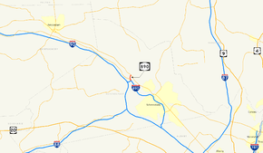
Map of the Schenectady area with NY 890 highlighted in redRoute information Maintained by NYSDOT Length: 1.00 mi[2] (1.61 km) Existed: 1998[1] – present Major junctions West end:  NY 5 in Glenville
East end:  I-890 in Rotterdam
Location Counties: Schenectady Highway system Numbered highways in New York
Interstate • U.S. • N.Y. (former) • Reference • County← I-890I-895  →
→New York State Route 890 (NY 890) is a 1.00-mile (1.61 km) long state highway located northwest of downtown Schenectady in the Capital District of New York. Although the route runs north–south, it is signed as east–west to match the posted direction of Interstate 890, of which NY 890 is an extension. The western terminus of the route is at NY 5 in Glenville. The eastern terminus is at an interchange with Interstate 890, where NY 890 becomes I-890 and continues east into Downtown Schenectady.
Part of the right-of-way of NY 890, including the bridges carrying what is now NY 890 over the ramp leading from NY 890 west to NY 5S, were constructed as early as 1990; however, the length of NY 890 did not open to traffic until 1998.
Contents
Route description
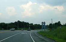 Western terminus of NY 890 at NY 5
NY 890 begins at an at-grade intersection with NY 5 in Glenville four miles (6 km) from downtown Schenectady. The route heads south as a four-lane limited-access highway with a speed limit of 55 miles per hour,[3] passing under the Delaware and Hudson Railway before crossing the Mohawk River into Rotterdam. Immediately after landing on the southern bank, NY 890 encounters the eastern terminus of NY 5S at exit 1A via a modified trumpet interchange. As the roadway crosses over a ramp leading from NY 890 westbound to NY 5S, NY 890 east widens to three lanes to interchange with Interstate 890 at exit 1B. Past the exit, NY 890 east narrows to two lanes and begins to turn to the southeast. Upon passing the westbound on-ramp to I-890, NY 890 becomes I-890.
History
Prior to 1990, traffic on I-890 westbound was forced to exit at modern-day exit 1B, which included I-90 and NY 5S at the time. Beyond the ramps to I-90, a short stretch of concrete roadbed continued north for several hundred feet before terminating north of the exit 1B overpass. Continuing northward on the future right-of-way of NY 890, the path of the highway consisted of only a graded roadbed up to the present location of exit 1A, where the bridges over what is now the ramp connecting NY 890 west to NY 5S were constructed but unused. The level ground continued to the south bank of the Mohawk River. No such construction was present north of the river.[4][5]
In the 1990s, the interchange with NY 5S was reconstructed by the New York State Department of Transportation, rerouting the ramp connecting I-890 west to NY 5S through the future right-of-way of NY 890 east. Later, the I-90 interchange was reconfigured and the NY 5S exit, the bridges for such partially constructed beforehand, was completed, allowing NY 890 to be constructed across the Mohawk River to NY 5. The roadway opened to through traffic in 1998.[1][4][5]
Exit list
The entire route is in Schenectady County.
Location Mile[2] Exit Destinations Notes Glenville 0.00 NY 5At-grade intersection Rotterdam 1A  NY 5S – Rotterdam Junction
Eastern terminus of NY 5S 1.00 1B 
 I-890 to I-90 / Thruway
Eastbound exit and westbound entrance 1.000 mi = 1.609 km; 1.000 km = 0.621 mi References
- ^ a b Sinsabaugh, Mark. "New York State Route 890". New York Routes. http://www.gribblenation.net/nyroutes/ind/800_999.htm#890. Retrieved February 12, 2007.
- ^ a b "2008 Traffic Data Report for New York State" (PDF). New York State Department of Transportation. June 16, 2009. p. 326. https://www.nysdot.gov/divisions/engineering/technical-services/hds-respository/NYSDOT_Traffic_Data_Report_2008.pdf. Retrieved January 10, 2010.
- ^ Wing, J.P.. "Interstate 890 Exit List". Upstate N.Y. Roads. http://www.upstatenyroads.com/i890.shtml. Retrieved February 12, 2007.
- ^ a b "Interstate 890". Kurumi. http://www.kurumi.com/roads/3di/i890.html. Retrieved February 12, 2007.
- ^ a b "Aerial image". USGS via Microsoft Research Maps. May 7, 1995. http://msrmaps.com/imageinfo.aspx?T=1&S=10&Z=18&X=2906&Y=23719&W=3. Retrieved February 12, 2007.
External links
Categories:- State highways in New York
- Limited-access roads in New York
- Transportation in Schenectady County, New York


Wikimedia Foundation. 2010.