- Niton
-
For the chemical element formerly known as Niton, see Radon. For the single by Eric Prydz, see Niton (The Reason).
Coordinates: 50°35′13″N 1°17′06″W / 50.58687°N 1.2849°W
Niton 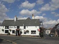
The White Lion, the village's pub.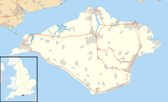
 Niton
Niton
Niton shown within the Isle of WightPopulation 1,142 (2001 census)[1] OS grid reference SZ507765 Parish Niton and Whitwell Unitary authority Isle of Wight Ceremonial county Isle of Wight Region South East Country England Sovereign state United Kingdom Post town VENTNOR Postcode district PO38 Dialling code 01983 Police Hampshire Fire Isle of Wight Ambulance Isle of Wight EU Parliament South East England UK Parliament Isle of Wight List of places: UK • England • Isle of Wight Niton is a village on the Isle of Wight, near Ventnor with a thriving population of 1142, supporting two pubs, several churches,a pottery workshop/shop, a pharmacy and 3 local shops including a post office. The post office houses a cafe which serves as a local meeting place.
Contents
Geography
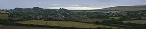 Panorama over Niton.
Niton village is split into two halves by a break in the inner cliff large enough to house the main road through Niton. Upper Niton lies in a hollow and is set around a crossroads. The lower part of the village, below the inner cliff is often known as Niton Undercliff, and was a small fishing hamlet until the 19th Century. This part of Niton flourished in Victorian times due to the popularity of Ventnor as a health resort, and many mansions and holiday cottages were built here. The road on the Undercliff continues east from Niton towards Ventnor. The Undercliff at Niton includes the most southerly point of the Isle of Wight, St. Catherine's Point and St. Catherine's Lighthouse.
The source of the Eastern Yar is in the parish, a little to the north of the village.[2]
Together with Whitwell, Niton composes a civil parish.[3]
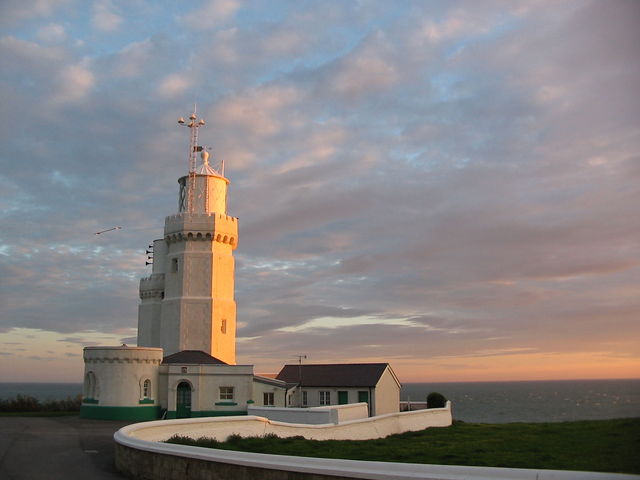
Niton lighthouse
 St Catherine's Lighthouse
St Catherine's Lighthouse was bombed in World War II, receiving a direct hit on the boiler house that killed three lighthouse keepers. The lighthouse itself was only slightly damaged, its lens only being chipped; the same lens is still used today.
Niton Church
Radio
Marconi used Knowles Farm in Niton as a location for radio experiments when he was living on the Isle of Wight in the late 1890s and early 1900s. In January 1901, he transmitted radio signals a record 186 miles from his transmitter station at Knowles Farm at the southern tip of the Isle of Wight to his Lizard Radio Telegraph Station at the southern tip of Cornwall. There is a stone at Knowles Farm into which is cut the inscription, "This is to commemorate that Marconi set up a wireless experimental station here in A.D. 1900". While in Niton, Marconi stayed at the Royal Sandrock Hotel[4] in Undercliff.
A ship-to-shore radio station was established in 1900 and Niton Radio (callsign GNI) was maintained as a coastal radio station well known to yacht masters - including being featured in a British Telecom International information film - until it finally closed, along with the rest of the coastal radio network, in 1997.[5]
Surfing
Niton has a reputation as a notoriously dangerous spot for Surfboarding a powerful rip current and a rocky landing await the surfer who attempts to tame Niton's powerful shore break. [6]
Governance
Niton lies within the parliamentary constituency of the Isle of Wight with the seat held by Conservative member Andrew Turner, and within the same area of the Isle of Wight Council. Together with Whitwell, the village forms a civil parish, chaired by Councillor John Andrew Stotesbury.[7] The Parish Council has ten members, six for the Niton ward and four for the Whitwell ward. The Council meets ten times a year alternating the venue between the two villages.[1]
Transport
Southern Vectis bus route 6 serves the village on its way between Newport and Ventnor, including intermediate villages.[8] During the summer, the Island Coaster also runs through the village.[9]
Notes and references
- ^ a b "Niton and Whitwell Parish Council". Isle of Wight Council. http://www.iwight.com/council/parish_councils/nitonwhitwell/. Retrieved 2009-06-16.
- ^ "River Yar Trail - Source to Sea". WightCam. http://www.wight-cam.co.uk/WightCAM/HTML/2002/020531-thumbnail.htm. Retrieved 2009-06-17.
- ^ "English Parishes & Welsh Communities N&C 2004". www.statistics.gov.uk. http://www.statistics.gov.uk/geography/geographic_area_listings/downloads/EnglishParishes&WelshCommunities_N&C_2004.xls. Retrieved 2007-05-03.
- ^ The Royal Sandrock Hotel no longer exists.
- ^ Coastradio reference site
- ^ http://wightsurfhistory.co.uk/?s=niton
- ^ "Isle of Wight Council - Niton and Whitwell Parish Council". Isle of Wight Council. http://www.iwight.com/parishcouncils/parishcouncilsdetail.aspx?id=16. Retrieved 2009-06-16.
- ^ "Southern Vectis - bus route 6". www.islandbuses.info. 2008. http://www.islandbuses.info/r6.shtml. Retrieved 2008-05-04.
- ^ "Southern Vectis Island Coaster". Southern Vectis. http://www.islandbuses.info/rx40.shtml. Retrieved 2009-06-16.
Ceremonial county of Isle of Wight Isle of Wight Portal Unitary authorities Major settlements Rivers Topics Categories:- Villages on the Isle of Wight
- Civil parishes in the Isle of Wight


Wikimedia Foundation. 2010.