- Downend, Isle of Wight
-
Coordinates: 50°41′14″N 1°13′54″W / 50.687360°N 1.231794°W
Downend 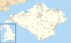
 Downend
Downend shown within the Isle of WightOS grid reference SZ532876 Unitary authority Isle of Wight Ceremonial county Isle of Wight Region South East Country England Sovereign state United Kingdom Post town NEWPORT Postcode district PO30 Dialling code 01983 Police Hampshire Fire Isle of Wight Ambulance Isle of Wight EU Parliament South East England UK Parliament Isle of Wight List of places: UK • England • Isle of Wight Downend is a settlement on the Isle of Wight, off the south coast of England. It is the location of the Robin Hill adventure park.
The hamlet lies to the north of the A3056 road, in the central-eastern district of the island. Downend is approximately 3 miles (4.8 km) south-east of Newport. Public transport is provided by Southern Vectis on route 8 and Wightbus on 33.
Categories:- Isle of Wight geography stubs
- Isle of Wight

Wikimedia Foundation. 2010.