- Chiques Creek
-
Chiques Creek 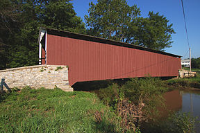
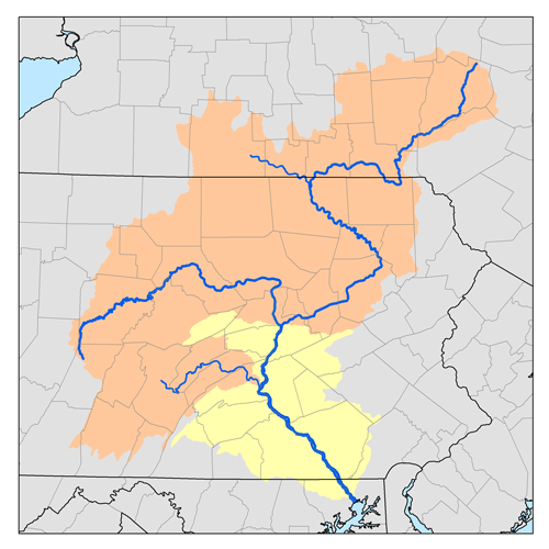
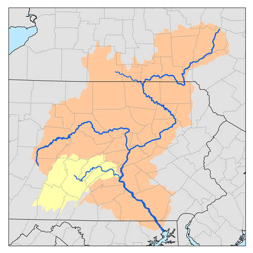
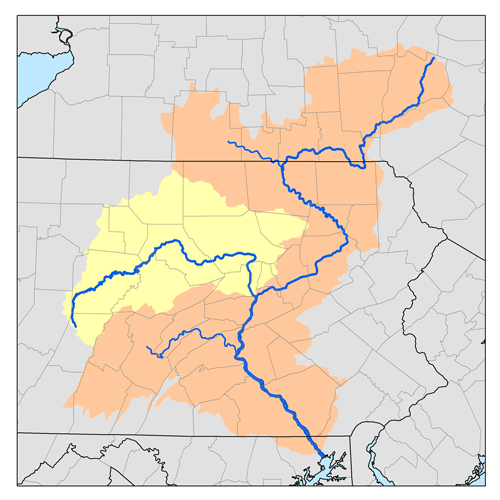
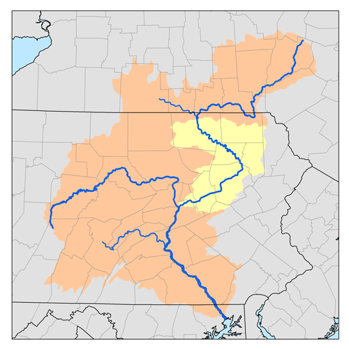
Kauffman's Distillery Covered Bridge spans Chiques Creek in Lancaster County, PennsylvaniaOrigin Mount Gretna Heights, Pennsylvania Mouth Susquehanna River at Marietta, Pennsylvania Basin countries Lebanon and Lancaster Counties, Pennsylvania, United States Length 31.6 miles (50.9 km) Source elevation 1,100 feet (340 m) Mouth elevation 230 feet (70 m) Basin area 126 square miles (330 km2) Chiques Creek (known as Chickies Creek until 2002) is a 31.6-mile-long (50.9 km)[1] tributary of the Susquehanna River in Lebanon and Lancaster counties, Pennsylvania in the United States.
The source is at an elevation of 1,100 feet (340 m) near Mount Gretna Heights in Lebanon County. The mouth is the confluence with the Susquehanna River at an elevation of 230 feet (70 m) at Marietta in Lancaster County.[2]
Contents
Name
The name of the creek comes from the Lenape Chiquesalunga, meaning "place of crayfish".[3]
The United States Geological Survey Board on Geographic Names has made three official decisions on the name of the creek, deciding it was Chickies Creek in 1896 and 1916 before changing it to Chiques Creek in 2002. The USGS Geographic Names Information System recognizes the following thirteen variant names for the creek: Big Chickies Creek, Big Chiques Creek, Big Chiquesalunga Creek, Chickesalapga Creek, Chickeswalungo Creek, Chickies Creek, Chickisalungo Creek, Chicques Creek, Chikiswalunga Creek, Chikiswalungo Creek, Chiquasatunga Creek, Chiquesatonga Creek, and Chiquesatunga Creek.[4]
Course and watershed
Chiques Creek flows generally south for its entire course. The Chickies Creek watershed has a total area of 126 square miles (330 km2) and is part of the larger Chesapeake Bay drainage basin. Chiques Creek's major tributary is Little Chiques Creek, entering roughly one mile upstream its mouth. (hence the variant names with Big in them for the main creek).[5]
Covered bridges
Five covered bridges cross the creek in Lancaster County:
- Shearer's Covered Bridge
- Kauffman's Distillery Covered Bridge
- Schenck's Mill Covered Bridge
- Siegrist's Mill Covered Bridge
- Forry's Mill Covered Bridge
Tributaries
- Donegal Creek
- Little Chiques Creek
- Dellinger Run
- Hife Run
- Boyers Run
- Shearers Creek
See also
References
- ^ U.S. Geological Survey. National Hydrography Dataset high-resolution flowline data. The National Map, accessed August 8, 2011
- ^ Shaw, Lewis C.. Pennsylvania Gazetteer of Streams Part II (Water Resources Bulletin No. 16). Prepared in Cooperation with the United States Department of the Interior Geological Survey (1st Edition ed.). Harrisburg, PA: Commonwealth of Pennsylvania, Department of Environmental Resources (no ISBN).
- ^ "Indian Names Data Chart". Susquehanna River Basin Commission. http://www.srbc.net/docs/IndianNamesDataChart.PDF. Retrieved 2006-09-04.
- ^ Geographic Names Information System, United States Geological Survey (August 30, 1990). "Geographic Names Information System Feature Detail Report: Chiques Creek". http://geonames.usgs.gov/pls/gnispublic/f?p=135:3:3703138462268723259::NO::P3_FID:1171772. Retrieved 2006-09-05.
- ^ "Chesapeake Bay Program: Watershed Profiles: The Chickies Creek - At Marietta Watershed". Chesapeake Bay Program Office, 10 Severn Avenue, Suite 109, Annapolis, MD 21403. http://www.chesapeakebay.net/wspv31/(3fwefm55tzka3q45qloiyxbu)/WspAbout.aspx?basno=254&topic=5. Retrieved 2006-09-03.
Categories:- Rivers of Pennsylvania
- Tributaries of the Susquehanna River
- Geography of Lancaster County, Pennsylvania
- Geography of Lebanon County, Pennsylvania

Wikimedia Foundation. 2010.