Mahantango Creek (Snyder County)
- Mahantango Creek (Snyder County)
-
For the Mahantango Creek in Dauphin, Schuylkill and Northumberland counties, see
Mahantango Creek.
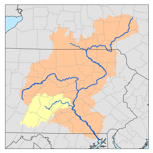
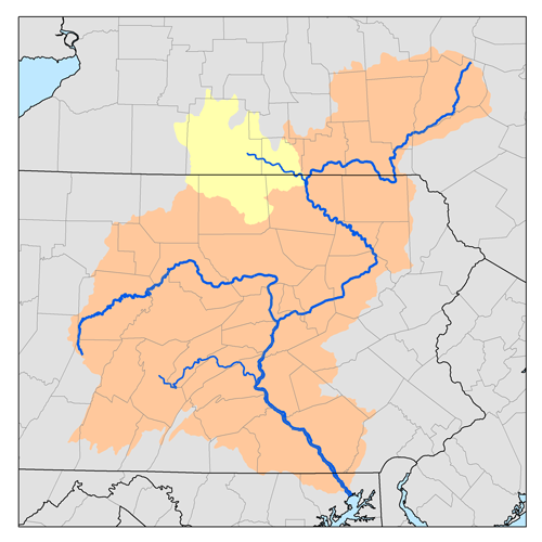
Mahantango Creek is a 2.1-mile-long (3.4 km)[1] tributary of the Susquehanna River in Snyder and Juniata counties, Pennsylvania, in the United States. The creek forms the border between Snyder and Juniata counties.
Mahantango Creek (Native American for "good hunting grounds") is formed by the confluence of the North Branch Mahantango Creek and West Branch Mahantango Creek at the Pennsylvania Route 104 crossing.
West Branch Mahantango Creek flows for 18.1 miles (29.1 km), rising on Shade Mountain northwest of Richfield and flowing generally southeast, forming the boundary between Snyder and Juniata counties for most of its course. The North Branch flows for 13.3 miles (21.4 km), also rising on Shade Mountain, to the east of the West Branch, then flowing east and southeast to its confluence with the West Branch to form Mahantango Creek, which continues southeast to its mouth at the Susquehanna River 5.5 miles (8.9 km) south of Port Trevorton.[1]
See also
References
- ^ a b U.S. Geological Survey. National Hydrography Dataset high-resolution flowline data. The National Map, accessed August 8, 2011
External links
Categories:
- Rivers of Pennsylvania
- Tributaries of the Susquehanna River
- Geography of Snyder County, Pennsylvania
Wikimedia Foundation.
2010.
Look at other dictionaries:
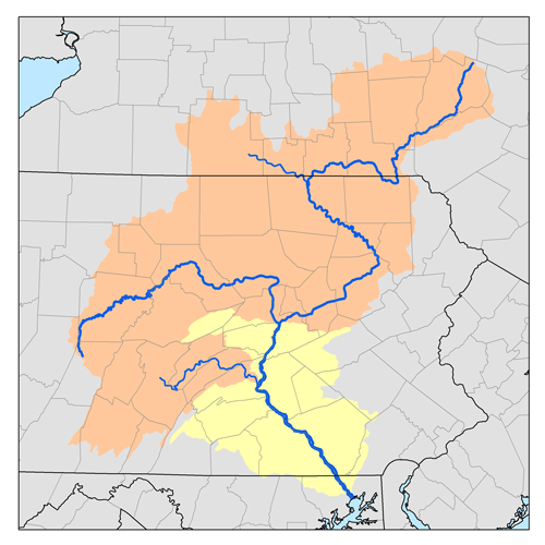
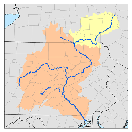
Mahantango Creek — For the Mahantango Creek in Snyder and Juniata counties, see Mahantango Creek (Snyder County). Mahantango Creek is a 36.2 mile long (58.3 km)[1] tributary of the Susquehanna River in Dauphin, Northumberland, and Schuylkill counties, in… … Wikipedia
Mahantango Formation — Stratigraphic range: Middle Devonian, 387 Ma … Wikipedia
Middle Creek (Penns Creek) — Middle Creek is a 31.7 mile long (51.0 km)[1] tributary of Penns Creek in Snyder County, Pennsylvania in the United States. Via Penns Creek, it is part of the Susquehanna River watershed. Middle Creek joins Penns Creek below Selinsgrove. See … Wikipedia
Muncy Creek — Map of the West Branch Susquehanna River (dark blue) and major streams in Lycoming County, Pennsylvania. Muncy Creek (light blue) is the fifth major creek to enter the river in the county, south of Loyalsock Creek (green). Little Muncy Creek is… … Wikipedia
Octoraro Creek — is a 22.1 mile long (35.6 km)[1] tributary of the Susquehanna River, joining it 9 miles (14 km) above the Susquehanna s mouth at Chesapeake Bay. The Octoraro rises as an East and West Branch in Pennsylvania. The East Branch and Octoraro … Wikipedia
Conewago Creek (east) — For the Conewago Creek in Adams and York Counties, on the west bank of the Susquehanna River, see Conewago Creek (west). Conewago Creek Origin Mount Gretna Heights, Pennsylvania Mouth Susquehanna River at Falmouth, Pennsylvania Basin countries… … Wikipedia
Conewago Creek (west) — For the Conewago Creek in Lebanon, Dauphin, and Lancaster Counties, on the east bank of the Susquehanna River, see Conewago Creek (east). Conewago Creek Origin Franklin Township, Adams County, Pennsylvania Mouth Susquehanna River at York Haven,… … Wikipedia
Chillisquaque Creek — Coordinates: 40°55′59″N 76°51′38″W / 40.93306°N 76.86056°W / 40.93306; 76.86056 … Wikipedia
Chiques Creek — Kauffman s Distillery Covered Bridge spans Chiques Creek in Lancaster County, Pennsylvania Origin Mount Gretna Heights, Pennsylvania … Wikipedia
Cocalico Creek — Bucher s Mill Covered Bridge spans Cocalico Creek in Lancaster County, Pennsylvania Origin Stricklerstown, Pennsylvania … Wikipedia