- New York State Route 326
-
NYS Route 326
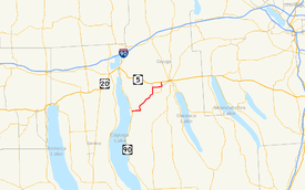
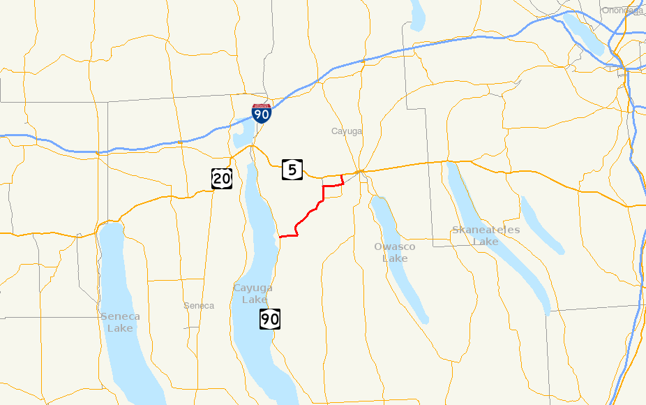
Map of the Auburn area with NY 326 highlighted in redRoute information Maintained by NYSDOT Length: 8.74 mi[2] (14.07 km) Existed: 1930[1] – present Major junctions West end:  NY 90 in Union Springs
East end: 
 US 20 / NY 5 near Auburn
Location Counties: Cayuga Highway system Numbered highways in New York
Interstate • U.S. • N.Y. (former) • Reference • County←  NY 324
NY 327  →
→New York State Route 326 (NY 326) is a state highway in Cayuga County, New York, United States. NY 326 runs in a southwest to northeast direction from the village of Union Springs to the city of Auburn. The western terminus of the route is at an intersection with NY 90 near the northern village line of Union Springs. Its eastern terminus is at a junction with U.S. Route 20 (US 20) and NY 5 just west of the Auburn city limits in the town of Aurelius. NY 326 passes through largely rural portions of the Finger Lakes region and does not pass through any built-up areas other than those at each of its termini.
NY 326 was assigned as part of the 1930 renumbering of state highways in New York as a connector highway between Union Springs and Auburn. However, its original alignment followed Oakwood Road and Genesee Street from the hamlet of Oakwood to downtown Auburn. It was realigned in the mid-1970s to end at US 20 and NY 5 west of downtown Auburn. In 1981, NY 326 was rerouted between the hamlets of Oakwood and Half Acre to follow Half Acre Road. NY 326's former routing between the two points is now maintained by Cayuga County.
Contents
Route description
NY 326 begins at an intersection with NY 90 near the northern village line of Union Springs. The highway heads eastward, following Auburn Street as it runs along the northern village boundary. It briefly parallels a former alignment of itself, now known as "Old Route 326", before exiting Union Springs and entering the surrounding town of Springport. Much of Springport, a town situated on the eastern shore of Cayuga Lake, is rural and largely undeveloped. The route passes by houses and fields as it proceeds to a junction known locally as "Powers Corner". Here, NY 326 turns northeastward and becomes known only by its designation as it heads toward the hamlet of Oakwood.[3]
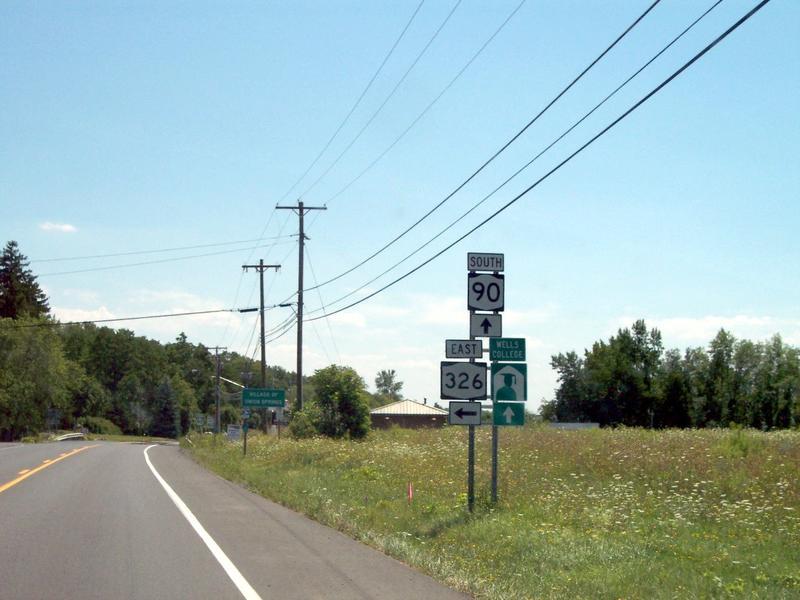
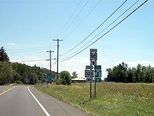 NY 326's western terminus just north of Union Springs at NY 90
In Oakwood, NY 326 passes several homes and intersects Oakwood Road, a north–south highway linking the community to West Genesee Street in the town of Aurelius to the north. At this junction, NY 326 becomes Half Acre Road, named for the hamlet of Half Acre to the northeast. The highway continues its northeastern track for 1.5 miles (2.4 km) before turning to the north and entering Half Acre, a small community in Aurelius that is built up around the junction of Half Acre Road and West Genesee Street. Here, NY 326 turns eastward to follow West Genesee Road toward the city of Auburn. It parallels US 20 and NY 5 for 1.5 miles (2.4 km) to the Veterans Memorial Parkway, which NY 326 turns northward onto. It briefly enters the Auburn city limits but ends at an intersection with Routes 5 and 20 just west of the Auburn city limits in Aurelius.[3]
History
NY 326 was assigned as part of the 1930 renumbering of state highways in New York and extended from the village of Union Springs to the city of Auburn. The route initially followed Oakwood Road and Genesee Street from the hamlet of Oakwood to Auburn,[1] where it ended at an intersection with NY 34 (South Street) in downtown Auburn.[4] A divided highway was built west of Auburn ca. 1975, connecting the overlapping routes of US 20 and NY 5 to NY 326. US 20 and NY 5 were rerouted to follow the new highway south to NY 326, and all three routes continued east into downtown on Genesee Street.[5][6][7] By 1977, US 20 and NY 5 were realigned once again to follow a new arterial leading from the north end of the divided highway eastward into downtown. NY 326, meanwhile, was realigned to follow the divided highway north to US 20 and NY 5.[8]
On April 1, 1981, NY 326 was realigned between the hamlets of Oakwood and Half Acre as the result of a highway maintenance swap between the state of New York and Cayuga County. As part of the swap, the state of New York assumed maintenance of Half Acre Road from Oakwood to Half Acre while maintenance of NY 326's former routing between the two locations was transferred to Cayuga County.[9][10][11] The former routing of NY 326 on Oakwood Road is now designated as County Route 168A (CR 168A) in the town of Aurelius and CR 168B in the town of Springport.[12][13] The Genesee Street portion of old NY 326 is now part of CR 1.[14] In the 1981 maintenance swap, the state of New York also assumed maintenance of the section of Half Acre Road between Half Acre (at NY 326) and the US 20 / NY 5 concurrency.[11] This portion of Half Acre Road is now NY 931E, an unsigned reference route.[15]
Major intersections
The entire route is in Cayuga County.
Location Mile[2] Destinations Notes Union Springs 0.00 NY 90 (North Cayuga Street)Aurelius 8.74 US 20 / NY 5 (Arterial East)1.000 mi = 1.609 km; 1.000 km = 0.621 mi References
- ^ a b Standard Oil Company of New York (1930). Road Map of New York (Map). Cartography by General Drafting.
- ^ a b "2008 Traffic Data Report for New York State" (PDF). New York State Department of Transportation. June 16, 2009. p. 294. https://www.nysdot.gov/divisions/engineering/technical-services/hds-respository/NYSDOT_Traffic_Data_Report_2008.pdf. Retrieved December 9, 2009.
- ^ a b Google, Inc. Google Maps – overview map of NY 326 (Map). Cartography by Google, Inc. http://maps.google.com/maps?hl=en&q=from%3A%20RT-326%20%4042.858017%2C%20-76.692108%20to%3A%20Unknown%20road%20%4042.929310%2C%20-76.594482&um=1&ie=UTF-8&sa=N&tab=wl. Retrieved May 9, 2008.
- ^ Thibodeau, William A. (1938). The ALA Green Book (1938–39 ed.). Automobile Legal Association.
- ^ Gulf (1974). New York and New Jersey Tourgide Map (Map). Cartography by Rand McNally and Company.
- ^ United States Geological Survey (1978). Auburn Quadrangle – New York – Cayuga Co. (Map). 1:24,000. 7.5 Minute Series (Topographic). http://www.nysgis.state.ny.us/gisdata/quads/drg24/usgspreview/index.cfm?code=o42076h5. Retrieved July 5, 2009.
- ^ Federal Highway Administration (2008). "Structure 1069180". National Bridge Inventory. United States Department of Transportation. http://nationalbridges.com/nbi_record.php?StateCode=36&struct=000000001069180. Retrieved July 5, 2009.
- ^ Exxon (1977). New York (Map). Cartography by General Drafting (1977–78 ed.).
- ^ State of New York (1981). I Love New York Tourism Map (Map). Cartography by Rand McNally and Company.
- ^ Rand McNally (1985). New York (Map). ISBN 0-528-91040-X.
- ^ a b New York State Legislature. "New York State Highway Law § 341". http://public.leginfo.state.ny.us/menugetf.cgi?COMMONQUERY=LAWS. Retrieved July 5, 2009.
- ^ Cayuga County Legislature (March 23, 2004). "Minutes of the Cayuga County Legislature" (PDF). p. 24. http://www.co.cayuga.ny.us/lclerk/leg_minutes/leg2004-03-23.pdf. Retrieved July 5, 2009.
- ^ New York State Department of Transportation. "Cayuga County Local Traffic Volume Report" (PDF). p. 2. https://www.nysdot.gov/divisions/engineering/technical-services/hds-respository/cayugalhitvbk.pdf. Retrieved July 5, 2009.
- ^ New York State Department of Transportation (1981). Cayuga Digital Raster Quadrangle (Map). 1:24,000. http://www.nysgis.state.ny.us/gisdata/quads/drg24/dotpreview/index.cfm?code=q25. Retrieved July 5, 2009.
- ^ New York State Department of Transportation (January 2009) (PDF). Official Description of Highway Touring Routes, Bicycling Touring Routes, Scenic Byways, & Commemorative/Memorial Designations in New York State. https://www.nysdot.gov/divisions/operating/oom/transportation-systems/repository/2009%20tour-bk.pdf. Retrieved July 29, 2009.
External links
Categories:- State highways in New York
- Transportation in Cayuga County, New York

Wikimedia Foundation. 2010.