- Diggers Rest, Victoria
-
Diggers Rest
Victoria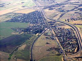
view from south east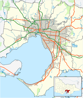
 Diggers Rest
Population: 2,381(2006) [1] Established: 1874 Postcode: 3427 Elevation: 153 m (502 ft) Location: LGA: Shire of Melton, City of Hume State District: Macedon Federal Division: Lalor Localities around Diggers Rest: Toolern Vale Sunbury Wildwood Toolern Vale Diggers Rest Bulla Ravenhall Keilor North Tullamarine Diggers Rest (formerly Diggers' Rest) is a town in Melbourne, Victoria, Australia, 33 km north-west from Melbourne's central business district. It lies on the old Calder Highway near the Calder Freeway. Its Local Government Area is the Shire of Melton and City of Hume. At the 2006 Census Diggers Rest had a population of 2,381.
Contents
History
Diggers Rest began life as a stopping place on the road to the Bendigo goldfields and the Post Office opened on 18 June 1860.[2] Caroline Chisholm started a women's shelter in the area. The town grew in the 1870s and 1880s and became a postal village with a general store, post office, weighbridge, mechanics' institute and a chaff mill.
It is famous for being the location of the first controlled powered flight of an aeroplane undertaken in Australia. The flight was performed by Harry Houdini in 1910.[3]
To the north of Diggers Rest township within the locality is the former township known as The Gap or Buttlejorrk.
Sunbury Rock Festival
The four Sunbury Pop Festivals were held on on the same 620-acre (2.5 km2) private farm along Jacksons Creek, on the southern outskirts of Sunbury, between Sunbury and Diggers Rest. The Property was owned by farmer and local identity George Duncan, and the property has become known in the district over the years simply as "Duncan's farm". The entrance gates to the Sunbury Pop Festivals was off Watsons Road. Also because of its close proximity (2 km) to the smaller township of Digger Rest, many of the attendees who traveled to Sunbury by train, actually alighted at Diggers Rest Railway station, and not Sunbury.
Present day
Diggers Rest contains a general store, a primary school and a CFA fire station, along with three large recreation reserves.[4] Sporting groups in Diggers Rest include Diggers Rest Football Club who play in the Riddell District Football League.
Diggers Rest Primary School was first opened in 1882 and moved to its present site in 1990. Diggers Rest Primary School features excellent facilities including air conditioned and heated classrooms, computer and Internet access to all grades, modern sports and playground equipment and landscaped grounds.
Diggers Rest Primary School is an integral part of the wider community and hosts annual events such as the Community Carols, Billy Cart Derby and Grandparents’ Day.
Other facilities in the Diggers Rest area include the Holden Flora and Fauna Reserve, Animal Land Children's Farm [1] and SPSK Jadran, a Slovenian social club which services nearby St Albans and Keilor.
Diggers Rest also has a Scout Group containing Cub Scouts and Scouts. They meet at the Diggers Rest Reserve behind the Tennis Club rooms.
Transport
Diggers Rest has a railway station on the Sunbury line, connecting the town with Melbourne's CBD.
Bus route connection with Moonee Ponds and with nearby Sunbury, at the former Victoria University campus.[5]
References
- ^ Australian Bureau of Statistics (25 October 2007). "Diggers Rest (State Suburb)". 2006 Census QuickStats. http://www.censusdata.abs.gov.au/ABSNavigation/prenav/LocationSearch?collection=Census&period=2006&areacode=SSC25479&producttype=QuickStats&breadcrumb=PL&action=401. Retrieved 2007-09-25.
- ^ Premier Postal History, Post Office List, https://www.premierpostal.com/cgi-bin/wsProd.sh/Viewpocdwrapper.p?SortBy=VIC&country=, retrieved 2008-04-11
- ^ Hargrave Pioneers: Harry Houdini
- ^ Map 351-352, Melway street directory (28th ed., 2001)
- ^ Sunbury Bus Service website, accessed 25 November 2006
External links
- Diggers Rest (Australian Gazetteer)
Coordinates: 37°37′41″S 144°43′16″E / 37.628°S 144.721°E
Suburbs of the Shire of Melton Brookfield · Burnside · Burnside Heights · Caroline Springs · Diggers Rest · Exford · Eynesbury •
Hillside · Kurunjang · Melton · Melton South · Melton West · Mount Cottrell · Parwan • Plumpton · Ravenhall · Rockbank · Taylors Hill · Toolern Vale · TruganinaSuburbs of the City of Hume | Melbourne | Victoria Attwood · Broadmeadows · Bulla · Campbellfield · Clarkefield · Coolaroo · Craigieburn · Dallas · Diggers Rest · Gladstone Park · Greenvale · Jacana · Kalkallo · Keilor · Meadow Heights · Melbourne Airport · Mickleham · Oaklands Junction · Roxburgh Park · Somerton · Sunbury · Tullamarine · Westmeadows · Wildwood · Yuroke
Categories:- Towns in Victoria (Australia)


Wikimedia Foundation. 2010.