- Chilmington Green
-
Coordinates: 51°07′48″N 0°49′58″E / 51.13°N 0.8327°E
Chilmington Green 
 Chilmington Green
Chilmington Green shown within KentDistrict Ashford Shire county Kent Region South East Country England Sovereign state United Kingdom Police Kent Fire Kent Ambulance South East Coast EU Parliament South East England UK Parliament Ashford List of places: UK • England • Kent Chilmington Green is a hamlet on the edge of the Kentish Weald comprising 10 listed buildings.
Ashford Borough Council is planning to build a new dormitory town of up to 7000 houses on 1000 acres of productive agricultural land around the hamlet.
The local residents are opposed to the plans and have launched a campaign to resist them.
The area home to numerous endangered species including great crested newts[1], water voles[2] and brown hares.

Great Chart Great Chart Singleton Bethersden 
Stanhope  Chilmington Green

Shirkoak Shadoxhurst Kingsnorth Towns and villages in the Ashford district of Kent, England 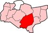 Aldington · Aldington Frith · Anvil Green · Appledore · Appledore Heath · Ashford · Bagham · Bethersden · Biddenden · Bilsington · Bilting · Bockhanger · Bodsham · Bonnington · Boughton Aluph · Boughton Corner · Boughton Lees · Brabourne · Brabourne Lees · Brattle · Bromley Green · Brook · Challock · Charing · Chilham · Chilmington Green · Crundale · Eastwell · Ebony · Egerton · Godinton · Godmersham · Great Chart · Hamstreet · Hastingleigh · High Halden · Hinxhill · Hothfield · Kenardington · Kennington · Kingsnorth · Leigh Green · Little Chart · Mersham · Molash · Newenden · Newtown · Orlestone · Pluckley · Reading Street · Rolvenden · Rolvenden Layne · Ruckinge · St Michaels · Sevington · Shadoxhurst · Small Hythe · Smarden · Smeeth · Stanhope · Stone in Oxney · Stubbs Cross · Tenterden · Warehorne · Westwell · Westwell Leacon · Willesborough · Wittersham · Woodchurch · Woolpack Corner · Wye
List of places in Kent References
Categories:- Ashford, Kent
- Villages in Kent


Wikimedia Foundation. 2010.