- Newtown, Kent
-
Newtown District Ashford Shire county Kent Region South East Country England Sovereign state United Kingdom Police Kent Fire Kent Ambulance South East Coast EU Parliament South East England UK Parliament Ashford List of places: UK • England • Kent Newtown is a suburb of Ashford in Kent, South East England, it was originally built by the South Eastern Railway company, adjacent to the railway station, and includes extensive workshops known as Ashford railway works, High Speed 1 runs past the area.
Ashford Green Corridor, a Local Nature Reserve, includes Newtown Green, adjacent to Newtown.
Locations in the
parish of AshfordBuildings Ashford International Station · Ashford railway works · Church · East Hill Mill · Victoria Flour MillsBusinesses Ailsa Craig Engines · Ashford Designer Outlet · Brake Bros Ltd · County Square · H.S. Pledge & Sons Ltd · Kentish ExpressEvents Military People Political Schools Ashford School · Highworth School · John Wallis Academy · South Kent College · The North School · The Norton Knatchbull SchoolSport, arts and leisure Media Ashford Herald · Kentish Express · KMFM AshfordTwin towns Towns and villages in the Ashford district of Kent, England 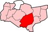 Aldington · Aldington Frith · Anvil Green · Appledore · Appledore Heath · Ashford · Bagham · Bethersden · Biddenden · Bilsington · Bilting · Bockhanger · Bodsham · Bonnington · Boughton Aluph · Boughton Corner · Boughton Lees · Brabourne · Brabourne Lees · Brattle · Bromley Green · Brook · Challock · Charing · Chilham · Chilmington Green · Crundale · Eastwell · Ebony · Egerton · Godinton · Godmersham · Great Chart · Hamstreet · Hastingleigh · High Halden · Hinxhill · Hothfield · Kenardington · Kennington · Kingsnorth · Leigh Green · Little Chart · Mersham · Molash · Newenden · Newtown · Orlestone · Pluckley · Reading Street · Rolvenden · Rolvenden Layne · Ruckinge · St Michaels · Sevington · Shadoxhurst · Small Hythe · Smarden · Smeeth · Stanhope · Stone in Oxney · Stubbs Cross · Tenterden · Warehorne · Westwell · Westwell Leacon · Willesborough · Wittersham · Woodchurch · Woolpack Corner · Wye
Coordinates: 51°08′N 0°53′E / 51.13°N 0.88°ECategories:- Ashford, Kent
- Kent geography stubs

Wikimedia Foundation. 2010.