- National Weather Service bulletin for New Orleans region
-
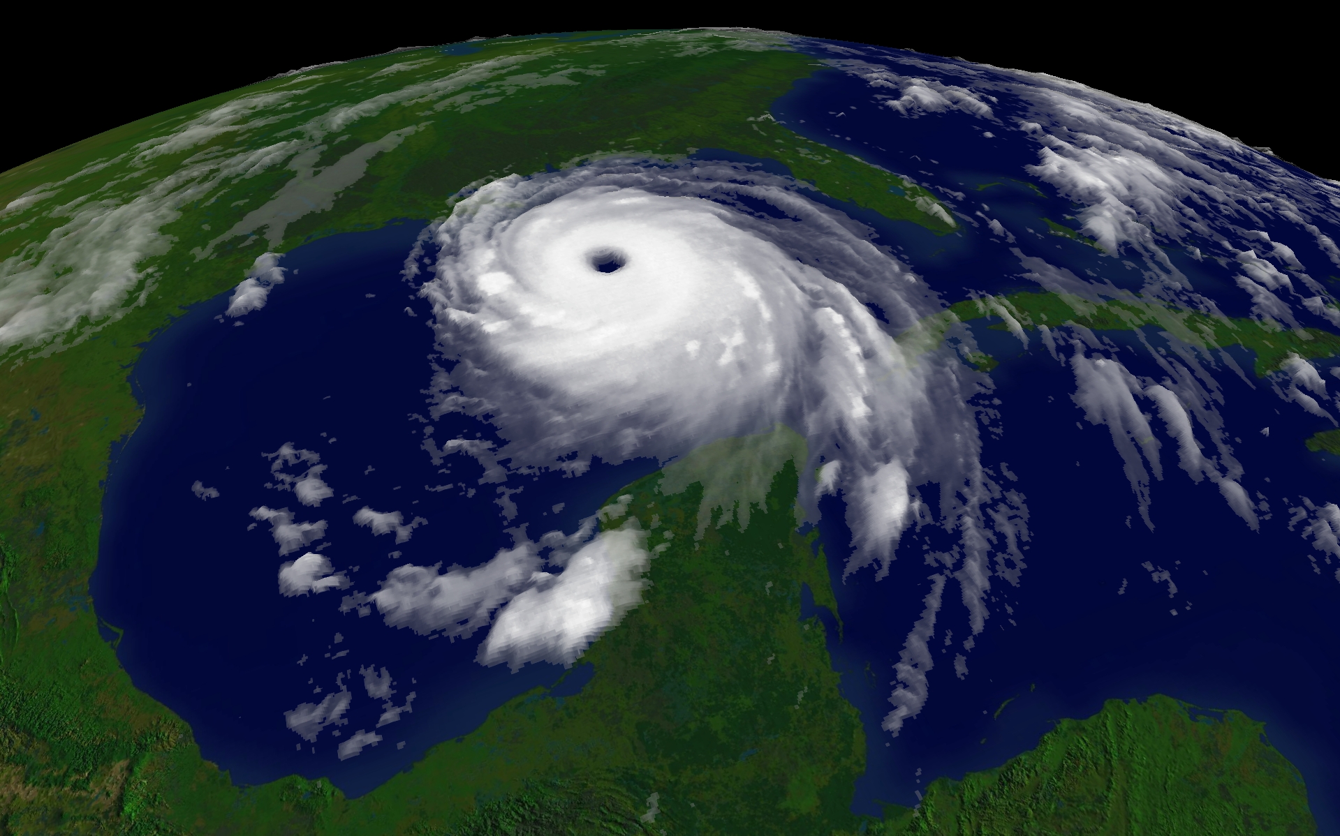
Hurricane Katrina 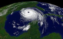
2005 Atlantic hurricane season General Impact Relief Analysis - Global warming
- Historical context
- Media coverage
External links  Media related to Hurricane Katrina at Wikimedia Commons
 News related to Katrina stories at Wikinews
 Works related to Katrina sources at Wikisource
The National Weather Service bulletin for the New Orleans region of 10:11 a.m., August 28, 2005 was a vividly worded release issued by the local Weather Forecast Office in Slidell, Louisiana, warning of the devastation that the Gulf Coast of the United States could experience as a result of Hurricane Katrina. Partly due to this bulletin, people in southeastern Louisiana and southern Mississippi, those most affected by the storm's impact, followed evacuation orders more closely, resulting in a reduced casualty toll.
Contents
Background
On the evening of August 25, 2005, Hurricane Katrina made landfall as a Category 1 hurricane near the Miami-Dade–Broward county line in southern Florida and weakened into a tropical storm as a result. The next morning, after passing over the state, Tropical Storm Katrina moved into the Gulf of Mexico, reintensified back to hurricane strength, and due to the warm waters of the Loop Current, began undergoing rapid deepening.[1]
At 11:00 p.m. EDT August 26, approximately 56 hours before Katrina's landfall near Buras, Louisiana, the National Hurricane Center had predicted that the Greater New Orleans area could face a direct hit by the storm.[2] As New Orleans is located on the Mississippi River Delta and parts of the city are below sea level, a strong hurricane could have a devastating effect on the city. Previous warnings, such as the one made by the Houston Chronicle in 2001, told of a disaster that "would strand 250,000 people or more, and probably kill one of 10 left behind as the city drowned under 20 feet of water" following a severe hurricane making landfall on the city.[3] The National Hurricane Center's director, Max Mayfield, indicated that the Mississippi/Louisiana area has "the greatest potential for nightmare scenarios," and that this has been known for at least the three decades he has worked at the NHC.[4] Other publications, such as Popular Mechanics, Scientific American, and The Times-Picayune gave doomsday scenarios in which a sinking city would drown and its residents would be left homeless.[5][6][7]
In 1965, Hurricane Betsy made landfall just south of New Orleans, causing widespread flooding in the city. As a result, a system of levees was authorized by Congress to handle future storm events. However, the protection given by this system was limited to hurricanes up to Category 3 intensity on the Saffir-Simpson Hurricane Scale.[8]
Three days before Katrina's second and third landfalls, the National Hurricane Center began predicting that the storm would make landfall as a major hurricane.[2] By the next morning, on August 27, the NHC issued a hurricane watch that included the New Orleans metro area,[9] which was upgraded to a hurricane warning by 10:00 p.m. CDT that same evening.[10] At this point, Katrina was a Category 3 hurricane with 115 mph (185 km/h) winds and about 335 miles (540 km) to the south-southeast of the Mississippi River's mouth.[10]
Bulletin text
On the night of August 27, Katrina underwent another episode of rapid deepening, strengthening to a Category 5 hurricane with maximum sustained winds of 175 mph (280 km/h) by 10:00 am CDT on August 28.[11] A few minutes later, at 10:11 a.m. CDT (1511 UTC), Robert Ricks, a meteorologist with the New Orleans/Baton Rouge NWS office, issued the following statement:[2][12][13] An equally-explicit bulletin was repeated at 4:13 p.m. CDT.[14]
“ 000 WWUS74 KLIX 281550 NPWLIX URGENT — WEATHER MESSAGE NATIONAL WEATHER SERVICE NEW ORLEANS LA 1011 AM CDT SUN AUG 28, 2005 ...DEVASTATING DAMAGE EXPECTED... .HURRICANE KATRINA...A MOST POWERFUL HURRICANE WITH UNPRECEDENTED STRENGTH...RIVALING THE INTENSITY OF HURRICANE CAMILLE OF 1969. MOST OF THE AREA WILL BE UNINHABITABLE FOR WEEKS...PERHAPS LONGER. AT LEAST ONE HALF OF WELL CONSTRUCTED HOMES WILL HAVE ROOF AND WALL FAILURE. ALL GABLED ROOFS WILL FAIL...LEAVING THOSE HOMES SEVERELY DAMAGED OR DESTROYED. THE MAJORITY OF INDUSTRIAL BUILDINGS WILL BECOME NON FUNCTIONAL. PARTIAL TO COMPLETE WALL AND ROOF FAILURE IS EXPECTED. ALL WOOD FRAMED LOW RISING APARTMENT BUILDINGS WILL BE DESTROYED. CONCRETE BLOCK LOW RISE APARTMENTS WILL SUSTAIN MAJOR DAMAGE...INCLUDING SOME WALL AND ROOF FAILURE. HIGH RISE OFFICE AND APARTMENT BUILDINGS WILL SWAY DANGEROUSLY...A FEW TO THE POINT OF TOTAL COLLAPSE. ALL WINDOWS WILL BLOW OUT. AIRBORNE DEBRIS WILL BE WIDESPREAD...AND MAY INCLUDE HEAVY ITEMS SUCH AS HOUSEHOLD APPLIANCES AND EVEN LIGHT VEHICLES. SPORT UTILITY VEHICLES AND LIGHT TRUCKS WILL BE MOVED. THE BLOWN DEBRIS WILL CREATE ADDITIONAL DESTRUCTION. PERSONS...PETS...AND LIVESTOCK EXPOSED TO THE WINDS WILL FACE CERTAIN DEATH IF STRUCK. POWER OUTAGES WILL LAST FOR WEEKS...AS MOST POWER POLES WILL BE DOWN AND TRANSFORMERS DESTROYED. WATER SHORTAGES WILL MAKE HUMAN SUFFERING INCREDIBLE BY MODERN STANDARDS. THE VAST MAJORITY OF NATIVE TREES WILL BE SNAPPED OR UPROOTED. ONLY THE HEARTIEST WILL REMAIN STANDING...BUT BE TOTALLY DEFOLIATED. FEW CROPS WILL REMAIN. LIVESTOCK LEFT EXPOSED TO THE WINDS WILL BE KILLED. AN INLAND HURRICANE WIND WARNING IS ISSUED WHEN SUSTAINED WINDS NEAR HURRICANE FORCE...OR FREQUENT GUSTS AT OR ABOVE HURRICANE FORCE...ARE CERTAIN WITHIN THE NEXT 12 TO 24 HOURS. ONCE TROPICAL STORM AND HURRICANE FORCE WINDS ONSET...DO NOT VENTURE OUTSIDE!
” Impact
In the months following the storm, Congress appointed a bipartisan committee to investigate the response to Hurricane Katrina and the preparations prior to its landfall. The committee concluded that the forecasts given by the National Weather Service were timely, were not responsible for failures in other agencies, and were likely responsible for saving thousands of lives.[4]
During an internal assessment by the National Weather Service, the 10:11 bulletin and its impact were analyzed. The report called the bulletin "a significant moment for the NWS during Katrina," as its detailed and explicit language did not have any previous precedent (though the message was based on a template designed by the Tampa Weather Office in the 1990s).[2] The strongly worded statement urged residents to evacuate, and was highlighted by national news media.[12] As a result, the level of detail was highlighted as an "innovative best practice" in the NWS assessment, which recommended issuing warnings with similar levels of detail in the future.[2][15] The bulletin was described as "perhaps the most chilling ever issued by the service".[16]
See also
- Effects of Hurricane Katrina in New Orleans
- Tropical cyclone watches and warnings
References
- ^ Knabb, Richard D.; Rhome, Jamie R. "Tropical Cyclone Report: Hurricane Katrina." National Hurricane Center. December 20, 2005.
- ^ a b c d e United States Department of Commerce (June 2006). "Hurricane Katrina Service Assessment Report" (PDF). http://www.weather.gov/om/assessments/pdfs/Katrina.pdf. Retrieved 2006-07-14.
- ^ Berger, Eric. "Keeping its head above water: New Orleans faces doomsday scenario." Houston Chronicle. December 1, 2001.
- ^ a b United States Congress (February 19, 2006) (PDF). A Failure of Initiative: Final Report of the Select Bipartisan Committee to Investigate the Preparation for and Response to Hurricane Katrina. Washington, DC: Government Printing Office. http://www.gpoaccess.gov/katrinareport/fullreport.pdf. Retrieved 2006-04-10.
- ^ Wilson, Jim. "New Orleans is Sinking." Popular Mechanics. September 11, 2001.
- ^ Fischetti, Mark. "Drowning New Orleans." Scientific American. October, 2001.
- ^ McQuaid, John; Schleifstein, Mark. "Washing Away." The Times-Picayune. June 23-June 27, 2002.
- ^ Westerink, J.J.; Luettich, R.A. "The Creeping Storm." Civil Engineering Magazine. June, 2003.
- ^ National Hurricane Center. "Hurricane Katrina Advisory Number 17, 10 a.m. CDT, August 27, 2005". National Oceanic and Atmospheric Administration. http://www.nhc.noaa.gov/archive/2005/pub/al122005.public.017.shtml?. Retrieved 2006-07-12.
- ^ a b National Hurricane Center. "Hurricane Katrina Advisory Number 19, 10 p.m. CDT, August 27, 2005". National Oceanic and Atmospheric Administration. http://www.nhc.noaa.gov/archive/2005/pub/al122005.public.019.shtml?. Retrieved 2006-07-12.
- ^ National Hurricane Center. "Hurricane Katrina Advisory Number 23, 10 a.m. CDT, August 28, 2005". National Oceanic and Atmospheric Administration. http://www.nhc.noaa.gov/archive/2005/pub/al122005.public.023.shtml?. Retrieved 2006-07-12.
- ^ a b Brian Williams (September 15, 2005). "The weatherman nobody heard". MSNBC. http://msnbc.msn.com/id/9358447/. Retrieved 2006-07-15.
- ^ "Urgent Weather Message." National Weather Service/New Orleans, Louisiana. August 28, 2005 @ 10:11 a.m. Retrieved on 2006-06-05.
- ^ "Urgent Weather Message." National Weather Service/New Orleans, Louisiana. August 28, 2005 @ 4:13 p.m. CDT. Retrieved on 2006-06-05.
- ^ Mark Schleifstein (July 4, 2006). "Katrina forecasters are lauded". The Times-Picayune. http://www.nola.com/news/t-p/metro/index.ssf?/base/news-15/115199317728170.xml&coll=1. Retrieved 2006-07-15.
- ^ Jay Barnes (2007). Florida's Hurricane History. Chapel Hill Press. p. 351. ISBN 0-8078-3068-2.
Categories:- Tropical cyclone meteorology
- Preparations for Hurricane Katrina
- Weather warnings and advisories
Wikimedia Foundation. 2010.