- Qinghai Lake
-
Qinghai Lake 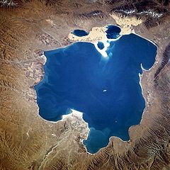
From space (November 1994). North is to the left. Location Tibetan Plateau Coordinates 37°00′N 100°08′E / 37°N 100.133°ECoordinates: 37°00′N 100°08′E / 37°N 100.133°E Lake type Shrunken lake Surface area 4,186 km2 (1,616 sq mi) (2004), 4,489 km2 (1,733 sq mi) (2007)[1] References [1] Qinghai Lake Chinese name Chinese 青海湖 Literal meaning "Blue Sea Lake" Transcriptions Mandarin - Hanyu Pinyin Qīnghǎi Hú Manchu name Manchu Huhu Noor Mongolian name Mongolian  Köke Naγur[2]
literally "blue lake"Tibetan name Tibetan མཚོ་སྔོན་ or
མཚོ་ཁྲི
་ཤོར་རྒྱལ་མོ་
(Wylie transliterations:
Mtsho-sngon-po or
Mtsho-khri-shor Rgyal-mo)Qinghai Lake (Chinese: 青海湖, pinyin: Qīnghǎi Hú, "Blue-green Sea Lake"; Tibetan: mTsho sngon po; historically Mongolian: Хөх нуур, Koko Nor, or Kukunor, "Blue Lake"), is a saline lake situated in the province of Qinghai, and is the largest lake in China. The names Qinghai and Kokonor both mean "Blue/Teal Sea/Lake" in Chinese and Mongolian. It is located about 100 kilometres (62 mi) west of the provincial capital of Xining at 3,205 m (10,515 feet) above sea level in a depression of the Tibetan Plateau in the traditional Tibetan province of Amdo.[3] Twenty-three rivers and streams empty into Qinghai Lake, most of them seasonal. Five permanent streams provide 80% of total influx.[4]
The lake has fluctuated in size, shrinking over much of the 20th century, but increasing since 2004. Despite its salinity, it has an abundance of fish, such as the edible naked carp (Gymnocypris przewalskii, huángyú (湟鱼)).[5]
Contents
Geography
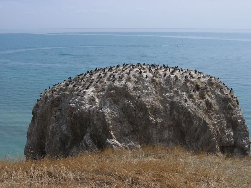
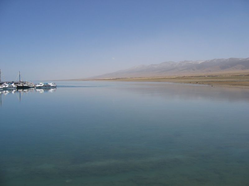
Qinghai Lake is sandwiched between Hainan and Haibei Tibetan Autonomous Prefectures in northeastern Qinghai. The lake is located at the crossroads of several bird migration routes across Asia. Many species use Qinghai as an intermediate stop during migration. As such, it is a focal point in global concerns of avian influenza (H5N1), as a major outbreak here could spread the virus across Europe and Asia, further increasing the chances of a pandemic. Minor outbreaks of H5N1 have already been identified at the lake. At the tip of the peninsula on the western side of the lake are the "Bird Islands" (Cormorant Island and Egg Island), which have been bird sanctuaries of the Qinghai Lake Natural Protection Zone since 1997. The lake often remains frozen for three months continuously in winter.
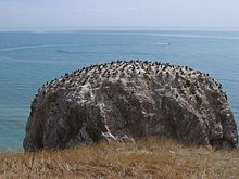 A bird island
There is an island in the western part of the lake with a temple and a few hermitages called "Mahādeva, the Heart of the Lake" (mTsho snying Ma hā de wa) which historically was home to a Buddhist monastery.[6] No boat was used during summer, only when the lake froze over in winter could monks reach the mainland or pilgrims visit the temple - many of whom used to come from Mongolia. A nomad described the size of the island by saying that: "if in the morning a she-goat starts to browse the grass around it clockwise and its kid anti-clockwise, they will meet only in the night, which shows how big the island is."[7] It is also known as the place where Gushri Khan and other Qoshot Mongols migrated to during the 1620s.[8]
The lake is also sometimes circumambulated by pilgrims from the region. Przhevalsky estimated it would take about 8 days by horse or 15 walking to circumambulate the lake, but pilgrims report it takes about 18 days on horseback, and one took 23 days walking to complete the circuit.[9]
History
Before the communist revolution in China in 1949, an annual ceremony was conducted to the God of the Lake. The Kuomintang Chinese Muslim General Ma Bufang, the Governor of Qinghai, and other high ranking Qinghai and Chinese government officials attended the Kokonuur Lake Ceremony where the God of the Lake was worshipped, and during the ritual, the Chinese national Anthem was sung, all participants bowed to a Portrait of Kuomintang party founder Dr. Sun Zhongshan, and the God of the Lake was also bowed to, and offerings were given to him by the participants, which included the Muslims.[10] Ma Bufang invited Kazakh Muslims to attend the Ceremony honoring the God.[11]
Splitting
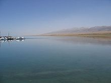 Qinghai Lake, May 2006
Prior to the 1960s, 108 freshwater rivers emptied into the lake. As of 2003, 85 % of the river mouths have dried up, including the lake's largest tributary, the Buha River. In between 1959 and 1982, there had been an annual water level drop of 10 centimeters, which was reversed at a rate of 10 cm/year between 1983 to 1989, but has continued to drop since. The Chinese Academy of Sciences reported in 1998 the lake was again threatened with loss of surface area due to livestock over-grazing, land reclamations and natural causes.[12] Lake surface area has decreased 11.7 percent in the period between 1908 and 2000 .[13] As a result of this, or possibly moving sand dune, higher lake floors were exposed, numerous water bodies were separated from the rest of the main lake around since the 20th century. In the 1960s, the 48.9 square kilometres (18.9 sq mi) Gahai Lake (尕海, pinyin: Gǎhǎi) appeared in the northern part of the lake. During the 1980s, Shadao Lake (沙岛, pinyin: Shādǎo) split out in the northwest covers an area of 19.6 km2 (7.6 sq mi), while the northeastern Haiyan Lake (海晏, pinyin: Hǎiyàn) is 112.5 km2 (43.4 sq mi).[14] Another 96.7 km2 (37.3 sq mi) daughter lake split off in 2004. In addition, the lake has now split into half a dozen more small lakes at the border. The water surface has shrunk by 312 km2 (120 sq mi) over the last three decades.[15]
See also
- Qinghai Lake railway station
- Tour of Qinghai Lake
References
- Buffetrille, Katia. "The Blue Lake of Amdo and Its Island: Legends and Pilgrimage Guide." In: The Tibet Journal Vol. XIX, No. 4, Winter, 1994.
- Andreas Gruschke: "The realm of sacred lake Kokonor", in: The Cultural Monuments of Tibet’s Outer Provinces: Amdo vol. 1. The Qinghai Part of Amdo, White Lotus Press, Bangkok 2001; pp. 93ff. ISBN 9-7475-3459-2
- Shakabpa, Tsepon W.D. Tibet: a Political History. New Haven: Yale University Press, 1962
- Footnotes
- ^ a b Qinghai Province Weather Bureau
- ^ cyrillic spelling is Хөх нуур, Khökh nuur
- ^ Buffetrille 1994, p. 2; Gruschke 2001, pp. 90 ff.
- ^ Rhode, David; Ma Haizhou, David B. Madsen, P. Jeffrey Brantingham, Steven L. Forman, John W. Olsen (2009). "Paleoenvironmental and archaeological investigations at Qinghai Lake, western China: Geomorphic and chronometric evidence of lake level history". Quaternary International: 3. http://paleo.sscnet.ucla.edu/RhodeEtAl-QI-2009.pdf. Retrieved 2010-03-18.
- ^ Su Shuyang: China ein Lesebuch zur Geschichte, Kultur und Zivilisation. Wissenmedia Verlag, 2008, p. 19. ISBN 3577143800
- ^ Gruschke 2001, pp. 93 ff.
- ^ Buffetrille 1994, pp. 2–3.
- ^ Shakabpa, Tsepon W.D. Tibet: a Political History. New Haven: Yale University Press, 1962
- ^ Buffetrille 1994, p. 2.
- ^ Uradyn Erden Bulag (2002). Dilemmas The Mongols at China's edge: history and the politics of national unity. Rowman & Littlefield. p. 51. ISBN 0742511448. http://books.google.com/books?id=g3C2B9oXVbQC&dq=ma+bufang+son&q=genocidal#v=snippet&q=ma%20bufang%20lake%20god%20scarves&f=false. Retrieved 2010-06-28.
- ^ Uradyn Erden Bulag (2002). Dilemmas The Mongols at China's edge: history and the politics of national unity. Rowman & Littlefield. p. 52. ISBN 0742511448. http://books.google.com/books?id=g3C2B9oXVbQC&dq=ma+bufang+son&q=genocidal#v=snippet&q=kazakh%20hui%20soldiers&f=false. Retrieved 2010-06-28.
- ^ [1][dead link]
- ^ [2][dead link]
- ^ [3][dead link]
- ^ Qinghai Lake splits due to deterioration. Chinadaily.com.cn (2004-02-24). Retrieved on 2010-09-27.
External links
 Media related to Lake Qinghai at Wikimedia Commons
- (Chinese) Qinghai Lake Protection and Utilization Administration Bureau (official)
- (Chinese) Qinghai Lake Tourism and Culture Network (official)
- More Birds in Qinghai Lake (Eastday.com.cn 07/17/2001)
 "Koko-nor". Encyclopedia Americana. 1920.
National parks of China Beidaihe • Benxi Shuidong National Park • Mount Cangyan • Chengde Mountain Resort • Dian Lake • Dujiangyan Irrigation System • Mount Emei • Fuxian Lake • Mount Heng (Hunan) • Mount Heng (Shanxi) • Hexigten Global Geopark • Mount Hua • Huangguoshu Waterfall • Huanglong, Sichuan • Mount Huang • Jade Dragon Snow Mountain • Jinggangshan Mountains • Jiuzhaigou Valley • Mount Lao • Mount Li • Longmen Grottoes • Mount Luofu • Mount Lu • Lushan Quaternary Glaciation National Geopark • Mount Jiuhua • Mount Mogan • Pearl Shoal Waterfall • Pudacuo National Park • Mount Putuo • Qianshan National Park • Mount Qingcheng • Qinghai Lake • Mount Qingyuan • Mount Qiyun • Mount Sanqing • Sanshan Islands • Shilin (Stone Forest) • Mount Song • Taihu Lake • Mount Tai • Mount Tianzhu • Wudang Mountains • Wulingyuan • Mount Wutai • Wuyi Mountains • Xixi National Wetland Park • Yuelu Mountain • Yun Mountain • Zhangjiajie National Forest Park • Wangwushan - Yuntaishan National Park •Qinghai topics General Geography Cities • Tibetan Plateau • Yellow River • Yangtze River • Mekong River • Tanggula Mountains • Kunlun Mountains • Qinghai Lake • Qaidam Basin • Sanjiangyuan National Nature ReserveEducation Qinghai University • Qinghai Normal University • Qinghai University for Nationalities • Qinghai Medical CollegeCulture Cuisine LiangfenVisitor attractions Xining • Qinghai LakeLakes of China Famous Freshwater Lakes Xingkai Lake • Poyang Lake • Lake Dongting • Lake Tai • Hulun Lake • Lake Hongze • Nansi Lake • Bosten Lake • Lake Chao • Gaoyou Lake • Ngoring Lake • Gyaring Lake • Lake Sayram • Baiyangdian Lake • Hong Lake • Longgan Lake • Liangzi Lake • Dian Lake • Ulansuhai Nur • Luoma Lake • Erhai Lake • Junshan Lake • Fuxian Lake • Shijiu Lake • Wabu Lake • Nanyi Lake • Dongping Lake • Ge Lake • Yangcheng Lake • Chenghai Lake • Dianshan Lake • Yangzong Lake • Xingyun Lake • Qilu Lake • Yilong Lake • Ayding Lake • Buir Lake • Chagan Lake (China) • Daming Lake • Diexi Lake • Dongqian Lake • Heaven Lake • Hundred Flower Pond • Karakul (China) • Kunming Lake • Lugu Lake • Ruyi Lake • South Lake (Jiaxing) • Tangjiashan Lake • White Cloud Lake • Xuanwu Lake • Yueya Lake (Nanjing)
Famous Salt Lakes Qinghai Lake • Namtso • Serling Lake • Zhari Namco • Tangra Yumco • Ulungur Lake • Yamdrok Lake • Pangong Tso • Lake Rakshastal • Aibi Lake • Ayding LakeNational Park Jingpo Lake • Wudalianchi Lake • Lake Tai • West Lake • East Lake (Wuhan) • Tianchi Lake (Tianshan) • Songhua Lake • Jingyue Lake • Slim West Lake • Lake Dongting • Hongfeng Lake • Lake Dian • Lake Jin (Taining) • Crescent Lake (Dunhuang) • Qinghai Lake • Lake Chao • Fairy Lake • West Lake (Huizhou) • Lake Qiong • Bosten Lake • Feiyun Lake • Huguang Rock • Bailong Lake • Lake Sayram • Huating Lake • Zhelin LakeProtected Wetlands Dongting Lake • Poyang Lake • Dalai Nur • South Dongting Lake • West Dongting Lake • Xingkai Lake • Bita Lake • Lake Napa • Lashi Lake • Ngoring Lake • Gyaring Lake • Manasarovar LakeNature Reserve Hengshui Lake • Xingkai Lake • Wudalianchi Lake • Shengjin Lake • Lake Poyang • Dongting Lake • Erhai Lake • Serling Lake • West Lake (Dunhuang) • Gahai Lake • Qinghai Lake • Caohai Lake • Dalai Nur • Kanas Lake • Lake Hongze • Haba LakeReservoirs Three Gorges Dam • Longtan Dam • Longyangxia Dam • Danjiangkou Dam • Sapung Lake • Qiandao Lake • Xinfengjiang Reservoir • Liujiaxia Reservoir • Changshou Lake • Yantan Dam • Jiangkou Reservoir • See also: List of dams and reservoirs in ChinaCategories:- Lakes of China
- Geography of Qinghai
- Shrunken lakes
- National parks of China
- Amdo

Wikimedia Foundation. 2010.