- Ordnance, Oregon
-
Ordnance — Ghost town — 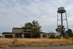 Location within the state of Oregon
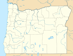
 Ordnance
Coordinates: 45°47′48″N 119°25′01″W / 45.79667°N 119.41694°WCoordinates: 45°47′48″N 119°25′01″W / 45.79667°N 119.41694°W Country United States State Oregon County Umatilla Elevation 587 ft (179 m) Time zone Pacific (PST) (UTC-8) – Summer (DST) PDT (UTC-7) ZIP codes 97882 Area code(s) 541 FIPS code GNIS feature ID 1136600 Ordnance is a ghost town in Umatilla County, Oregon, United States, southwest of Hermiston on Interstate 84/U.S. Route 30, near the intersection with Interstate 82. According to Oregon Geographic Names, the United States Department of War commissioned the establishment of Umatilla Ordnance Depot (renamed Umatilla Army Depot and currently Umatilla Chemical Depot) in northern Umatilla County in 1941. The town was named after the depot, and Ordnance post office was established in 1943. By the 1960s, Ordnance was no longer a community.[1]
See also
References
- ^ Fuzi, Donna (April 8, 1999). "Oral history". Center for Columbia River History. http://www.ccrh.org/comm/umatilla/oralhis/donfuzi.htm. Retrieved October 16, 2011.
External links
- Historic photo of the Umatilla Ordnance Depot from the Oregon Historical Society
- History of the depot from the Center for Columbia River History
Municipalities and communities of Umatilla County, Oregon Cities 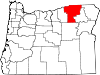
CDPs Cayuse | Gopher Flats | Kirkpatrick | Mission | Riverside | Tutuilla
Unincorporated
communitiesIndian reservation Ghost towns Blakeley | Ordnance | Riverview
Categories:- Geography of Umatilla County, Oregon
- Ghost towns in Oregon
- Oregon geography stubs
- United States military stubs


Wikimedia Foundation. 2010.