- Myrick, Oregon
-
Myrick is an unincorporated historic locale in Umatilla County, Oregon, United States.[1] It is located between Pendleton and Helix, just south of Oregon Route 334.[2]
Myrick is a station on the Burlington Northern Railroad that was originally named "Warren".[3] Because of the confusion with Warren in Columbia County, the name was changed to honor Samuel Jackson Myrick, who came to Oregon from Missouri in 1884 and settled in the area.[3] Myrick post office ran from 1902 to 1908.[3] John Myrick was the first postmaster.[3]
The Myrick family became successful wheat farmers in the area.[4]
References
- ^ "Myrick (historical)". Geographic Names Information System, U.S. Geological Survey. November 28, 1980. http://geonames.usgs.gov/pls/gnispublic/f?p=gnispq:3:::NO::P3_FID:1637853. Retrieved 2010-12-12.
- ^ Oregon Atlas & Gazetteer (7th ed.). Yarmouth, Maine: DeLorme. 2008. p. 74k. ISBN 0-89933-347-8.
- ^ a b c d McArthur, Lewis A.; McArthur, Lewis L. (2003) [First published 1928]. Oregon Geographic Names (7th ed.). Portland, Oregon: Oregon Historical Society Press. p. 687. ISBN 9780875952772. OCLC 53075956.
- ^ Gaston, Joseph; George H. Himes (1912). The Centennial History of Oregon, 1811-1912. Vol. 2. S.J. Clarke Publishing Co.. pp. 389–390. http://books.google.com/books?id=c78UAAAAYAAJ&pg=PA389&lpg=PA389.
Municipalities and communities of Umatilla County, Oregon County seat: Pendleton Cities 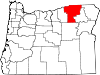
CDPs Cayuse | Gopher Flats | Kirkpatrick | Mission | Riverside | Tutuilla
Unincorporated
communitiesIndian reservation Ghost towns Coordinates: 45°48′15″N 118°42′52″W / 45.8042983°N 118.7144280°W
Categories:- Unincorporated communities in Umatilla County, Oregon
- Oregon geography stubs

Wikimedia Foundation. 2010.