- Oregon Route 335
-
Oregon Route 335
Route information Maintained by ODOT Length: 9.79 mi (15.76 km) Existed: 2003 – present Major junctions South end:  OR 11 near Havana
 OR 334 near Myrick
OR 334 near HelixNorth end: Columbia Street and Main Street in Helix Highway system Oregon highways
Routes • Highways← OR 334OR 339  →
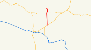
→Oregon Route 335 is an Oregon state highway running from Helix to OR 11 near Pendleton. OR 335 is known as the Havana-Helix Highway No. 335 (see Oregon highways and routes). It is 9.79 miles (15.76 km) long and runs north–south, entirely within Umatilla County.
OR 335 was established in 2003 as part of Oregon's project to assign route numbers to highways that previously were not assigned, and, as of July 2010, was unsigned.
Contents
Route description
OR 335 begins at the intersection of Columbia and Main Streets in Helix and heads south 2.40 miles (3.86 km) to an intersection with OR 334. OR 334 and OR 335 overlap for 1.13 miles (1.82 km), heading south, after which OR 334 turns west toward Myrick and OR 335 continues south through Midway. OR 335 ends at an intersection with OR 11 4.24 miles (6.82 km) south of Midway near the community of Havana.
History
OR 335 was assigned to the Havana-Helix Highway in 2003.
Major intersections
Milepost City Intersection 0.00 Helix Begin Route 2.40 Near Helix OR 334 (Begin concurrency) 3.53 Near Myrick OR 334 9.79 Near Havana OR 11 References
- Oregon Department of Transportation, Descriptions of US and Oregon Routes, http://www.oregon.gov/ODOT/HWY/TRAFFIC/TEOS_Publications/PDF/Descriptions_of_US_and_Oregon_Routes.pdf, page 30.
- Oregon Department of Transportation, Havana-Helix Highway No. 335, ftp://ftp.odot.state.or.us/tdb/trandata/maps/slchart_pdfs_1980_to_2002/Hwy335_1996.pdf
Categories:- State routes in Oregon
- Transportation in Umatilla County, Oregon


Wikimedia Foundation. 2010.