- Red Line (Chicago Transit Authority)
-
Red Line 
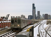
A Red Line train in the Jackson/State stationOverview Type Rapid transit System Chicago 'L' Status Operational Locale Chicago, Illinois, USA Termini Howard
95th/Dan RyanStations 33 Daily ridership 266,326
(avg. weekday Sep. 2011)Operation Operator(s) Chicago Transit Authority Character Underground and Elevated Rolling stock 2600-series Technical Line length 23.4 mi (37.7 km) Track gauge 4 ft 8 1⁄2 in (1,435 mm) Electrification Third rail, 600 V DC Route map 
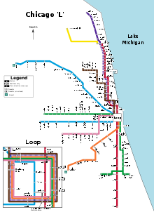
Howard 

Jarvis Morse Loyola Granville Thorndale Bryn Mawr Berwyn Argyle Lawrence Wilson Sheridan Addison Belmont Fullerton North/Clybourn Clark/Division Chicago Grand Lake 
Monroe Jackson Harrison Roosevelt Cermak–Chinatown Sox–35th 47th Garfield 63rd 69th 79th 87th 95th/Dan Ryan Map Legend Transfer to Blue Line Transfer to Brown Line Transfer to Green Line Transfer to Orange Line Transfer to Pink Line Transfer to Purple Line Transfer to Yellow Line ADA accessible station Parking Transfer to Metra Trains The Red Line is a heavy rail line in Chicago, run by the Chicago Transit Authority (CTA) as part of the Chicago 'L' system. It is CTA's busiest rail line, serving an average of 266,326 passengers each weekday as of September 2011.[1] The route is 23.4 miles (37.7 km) long with a total of 33 stations, from Rogers Park (Howard Street) on the City Limits north, through downtown Chicago, and to Roseland (95th/Dan Ryan) on the south. Like the Blue Line, the Red Line runs 24 hours/365 days a year.
Contents
Route
North Side Mainline


The northern terminus of the Red Line is Howard Street in the Rogers Park neighborhood of Chicago (7600 N. - 1700 W.), on the City Limits farthest north. The Red Line extends southeasterly on an elevated embankment structure about a half-mile (1 kilometer) west of the lakefront to Touhy Avenue then turns south along Glenwood Avenue to Morse station. From there the route swings on a sweeping reverse curve to the east to Sheridan Road, adjacent to Loyola University Chicago and continues southerly parallel to Broadway Avenue to the east (in Edgewater) and follows Broadway to Leland Avenue. From here, the route transitions from concrete embankment to steel elevated structure. The 'L' continues southward running adjacent the Graceland Cemetery, Irving Park Road and Sheffield Avenue from Uptown to Lincoln Park. The Brown Line (Ravenswood) joins the Red Line tracks just north of the Belmont Avenue station.
South of Belmont, Red and Brown Line trains run side-by-side on the four track North Side 'L' to Armitage Avenue.
State Street Subway
At Armitage, the Red Line descends to a portal at Willow Street and becomes a subway route, turning southeast in Clybourn Avenue, east in Division Street, and south in State Street through the Loop to Roosevelt Road. South of Roosevelt Road, there is a junction, with one pair of tracks curving to the east and leaving the subway at 13th Street and connects to the old South Side 'L' near 16th and State Streets. This section was used between October, 1943 and February, 1993 when North Side trains were routed to Englewood and Jackson Park. It is now used for non-service train moves and emergency purposes.
From the Red Line, passengers can directly transfer to any other Chicago 'L' line. This is unique to it and the Purple Line, when the Purple Line runs its rush hour route.
Dan Ryan Branch

Back at 13th Street the subway swings away from State Street on a reverse curve to the southwest then rises to another portal near 18th Street adjacent Metra's Rock Island District commuter railroad line. The Red Line bridges 18th Street and continues southward on a steel column pan concrete deck elevated structure to 24th Street. The Cermak-Chinatown station is in this section.
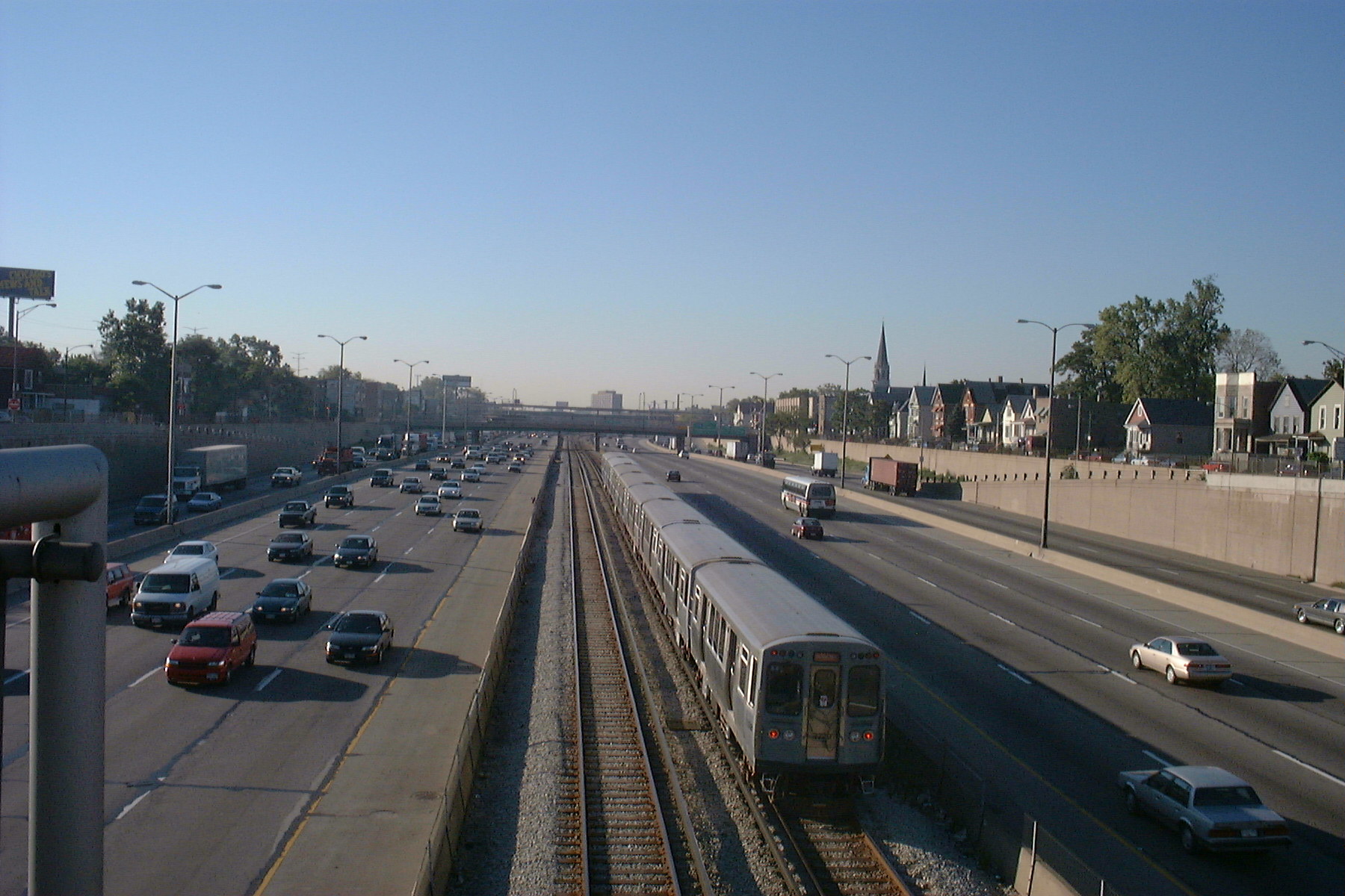
South of Cermak Road, the Red Line tracks run along the median strip of the Franklin Street Connector, a once-planned feeder branch of the Dan Ryan Expressway. The Red Line then tunnels beneath the expressway interchange between 28th and 30th Streets and continues southward now occupying the median strip of the Dan Ryan Expressway (Interstate 90 & 94). Chicago pioneered using expressway medians for local subway lines. The Red Line follows the Dan Ryan the rest of the way to the 95th Street terminal (9500 S. - 1 W.) in Roseland. The 98th Street Yard and Carhouse lie just south and east of the Dan Ryan-Bishop Ford Expressway interchange. Beyond the interchange, the Dan Ryan and Bishop Ford expressways continue towards the City's Limits south without a transit line in the median strip, but with a wide grass median where future extensions of the rapid transit line can be an option. Extensions going even further south are currently being planned for the Red Line, but no determination as of yet on whether the extension will continue on the median or become elevated.
Stations along the Red Line serve important Chicago landmarks such as Wrigley Field (Addison), U.S. Cellular Field and the Illinois Institute of Technology (Sox-35th), DePaul University (Fullerton), the Auditorium Building of Roosevelt University, and Loyola University Chicago (Loyola), as well as the Magnificent Mile and Chinatown.
Operating fleet
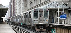
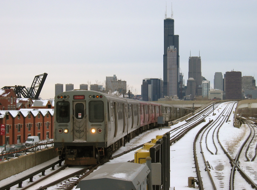
Currently, the Red Line is operated only with Budd-built 2600-Series rail cars. If there is a shortage of cars at the Howard Yard during rush hour, Boeing-Vertol-built 2400-Series Purple Line cars will sometimes appear on the Red Line, usually in mixed consists with 2600-series cars. Like the Blue Line, the Red Line runs 24 hours a day. Service has a 4 to 6 minute headway during peak periods with 8-car trains, and a 15 minute headway during the early morning hours with 4 to 8 car trains.
History
The Red Line was created in 1993 when the CTA adopted color-coded nomenclature for all of its 'L' routes. The oldest section of the route opened on May 31, 1900 on the north side between Wilson and Broadway Avenues and the Loop.[2] It was constructed by the Northwestern Elevated Railroad. The route was extended to Central Street in Evanston on May 16, 1908 via leased and electrified trackage belonging to the Chicago, Milwaukee and St. Paul Railway, and then to Linden Avenue in Wilmette on April 2, 1912. In November, 1913, the North Side 'L' was through routed with the South Side 'L' lines through the Union Loop. The ground-level section between Leland Avenue and Howard Street was elevated on a concrete embankment structure and expanded to four tracks in 1922.
The State Street Subway was completed in 1943 providing two new tracks bypassing the portion of the North and South Side 'L' lines not equipped with express tracks. By providing an express route free of the most restrictive curves on the Chicago 'L' and shorter than the old line it supplemented (thanks to use of a diagonal street, Clybourn Avenue, for one leg of the route), the subway reduced running time by as much as 11 minutes for a one-way trip. The route was placed in operation October 17, 1943,[3] for a portion of the through north-south trains although other trains continued to use the 'L' both on through trips and on services circling the Loop and returning to the point of origin.
On August 1, 1949, the North-South route was revised to create a more efficient routing through the Central Business District and handle the heavy volumes of passenger traffic using it.[4][5] Thus, the Howard line was combined with the Jackson Park-Englewood lines through the State Street Subway, and the other lines routed to the Loop 'L'.
The Dan Ryan Branch was opened September 28, 1969, and was originally combined with the Lake Street line to form the West-South route (Lake-Dan Ryan).[6] It operated over the Lake Street and Wabash Avenue sides of the Union Loop. This "interim" service was created mainly for the purpose of providing through service between the west side and the south side in anticipation of the 1968 Loop Subway Project. When the controversial subway project was cancelled in 1979, the Lake-Dan Ryan service remained, and lasted for nearly 24 years.
 A 2600 series car brings up the rear of a Red Line train (temporarily rerouted through the elevated tracks of the Chicago Loop) at Randolph/Wabash.
For much of the twentieth century, the Howard-Englewood/Jackson Park route was equally compatible in terms of passenger traffic until the late 1960s through the 1970s. However, passenger traffic volumes began to shift on the south side lines, with more riders using the newer Dan Ryan line (which runs four miles (6 km) further south) and fewer riders on the older 'L' lines. This imbalance of service allowed the CTA to develop a more efficient system by combining the more heavily used rail lines together, and the weaker lines with each other, providing increased service capacity for the routes that need it. Thus, on February 21, 1993 the Howard branch was combined with the Dan Ryan branch creating the present Red Line, and the Lake Street branch was paired with the Englewood-Jackson Park routes to form the Green Line. A further operational benefit of this switch was that there was now additional available capacity on the Loop 'L', which was required for the soon-to-open Orange Line.
The Dan Ryan branch of the Red Line underwent a rehabilitation period to improve its aging infrastructure which ended in early 2007.[7] This work included upgrading the power and signal systems, and rehabilitating the stations with improved lighting, a cleaner appearance, and new escalators and elevators. The CTA has plans to expand Red Line to 10-car trains from the current eight-car trains.[8]
Dan Ryan Extension
Proposals are currently underway to extend the Red Line south from 95th Street. The CTA has developed nine different proposed routes, one of which includes routing the Red Line down the median of the Bishop Ford Freeway and another in the median of Interstate 57. At an alternatives analysis meeting on April 11, 2007, CTA recommended narrowing further study down to five possible routes, two for bus rapid transit and three for heavy rail (rapid) transit. The two bus routes would travel south from the 95th/Dan Ryan terminal either down Halsted Street or Michigan Avenue, and the heavy rail routes left for consideration are the Halsted and Michigan corridors (either underground or elevated) as well as the Union Pacific Railroad corridor (elevated or trench), which would traverse southeastward toward the South Shore Line. In October 2008 the CTA commissioned a $150,000-study of an extension due south to 130th/Stony Island in the community area of Roseland.[9]
In December 2008, at the Screen 2 presentation of the federally mandated Alternatives Analysis Study, the possible corridors and modes of transit were narrowed down to Halsted Street (Bus Rapid Transit or elevated Heavy Rail Transit) and the Union Pacific Railroad corridor (elevated Heavy Rail Transit).[10]
In December 2009, the CTA identified the Locally Preferred Alternative, which is the Union Pacific corridor.[11] A map and description of the route are found here: [2] Multiple Environmental Impact Studies will be carried out, and will determine exact alignments and design.[11][12] The extension could potentially go into service in 2016.[12]
Station listing

Red Line (Howard Branch) Station Location Points of interest and notes Howard 1649 W. Howard Street Rogers Park Transfer station for Yellow and Purple Lines
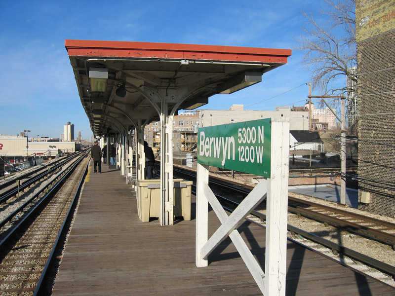
Jarvis 1523 W. Jarvis Avenue Rogers Park, Emil Bach House Morse 1358 W. Morse Avenue Rogers Park, Heartland Cafe Loyola 1200 W. Loyola Avenue Rogers Park, Loyola University Chicago Lakeshore Campus Granville 1119 W. Granville Avenue Edgewater, Berger Park, Gerber/Hart Library Thorndale 1118 W. Thorndale Avenue Edgewater, Edgewater Public Library, Thorndale Beach Bryn Mawr 1119 W. Bryn Mawr Avenue Edgewater, Bryn Mawr Historic District, Edgewater Beach Hotel, Hollywood Beach Berwyn 1121 W. Berwyn Avenue Edgewater, Foster Beach Argyle 1118 W. Argyle Avenue Uptown, New Chinatown, Essanay Studios, St. Augustine College, Bachman House, Bezazian Public Library, Lawrence 1117 W. Lawrence Avenue Uptown, Uptown Theatre, Riviera Theatre, Aragon Ballroom Wilson 4620 N. Broadway Uptown, Harry S Truman College Buena Buena Street and Kenmore Avenue Closed August 1, 1949 Sheridan 3940 N. Sheridan Road Graceland Cemetery, Howard Brown Health Center, Thorek Memorial Hospital Grace Closed August 1, 1949 Addison 940 W. Addison Street Lakeview, Wrigley Field- home of the Chicago Cubs, Metro, Wrigleyville, Center on Halsted, the I.O. Theater, formerly improvolympic Clark Clark Street and Roscoe Street Closed August 1, 1949 Belmont 945 W. Belmont Avenue Lakeview, Briar Street Theatre, Boystown, The Vic Theatre Transfer station for Purple and Brown Lines
Fullerton 943 W. Fullerton Avenue Lincoln Park, DePaul University, Children's Memorial Hospital, St. Josaphat Roman Catholic Church, Biograph Theater Transfer station for Purple and Brown Lines
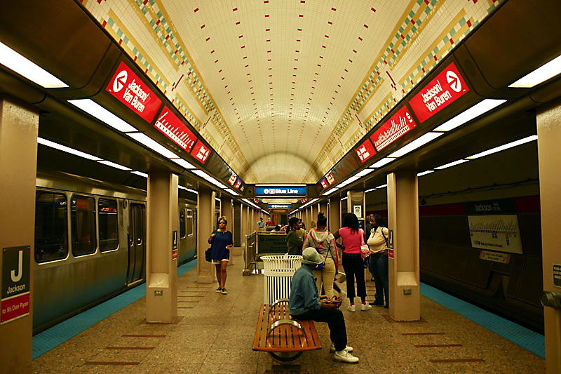
Red Line (State Street Subway) Station Location Points of interest and notes North/Clybourn 1599 N. Clybourn Avenue Steppenwolf Theatre Company, Goose Island Brewery, Chicago History Museum, Apple Store Clark/Division 1200 N. Clark Street Newberry Library, Walter Payton College Prep High School Chicago 800 N. State Street John Hancock Center, Chicago Water Tower, Water Tower Place, Loyola University Chicago Water Tower Campus, Moody Bible Institute, Northwestern University Feinberg School of Medicine, Museum of Contemporary Art, Holy Name Cathedral Grand (open during construction) 521 N. State Street Navy Pier, Medinah Temple Lake 200 N. State Street Chicago Theatre, Chicago Cultural Center, Macy's Transfer station for Orange, Green, Purple, Pink, and Brown Lines via State/Lake, Blue Line via Washington/Dearborn, and Metra Electric and South Shore Line trains via the Pedway to Millenium Station.
Washington 128 N. State Street Closed October 23, 2006; Former transfer station for Blue Line, Metra trains (Metra Electric Line), and South Shore Line Monroe 26 S. State Street Art Institute of Chicago, Carson, Pirie, Scott and Company Building Jackson 230 S. State Street Grant Park, Petrillo Music Shell, Buckingham Fountain, Harold Washington Library Center, DePaul University, Robert Morris University, John Marshall Law School, Chicago Bar Association and The Auditorium Building of Roosevelt University Transfer station for Blue Line
Transfer station for Orange, Purple, Pink, and Brown Lines via Harold Washington Library – State/Van BurenHarrison 608 S. State Street Columbia College Chicago, Dearborn Station, Printing House Row District, Jones College Prep Roosevelt 1167 S. State Street Field Museum, Shedd Aquarium, Adler Planetarium, Northerly Island (formerly Meigs Field), Soldier Field-Home of Chicago Bears Transfer station for Orange and Green Lines
Red Line (Dan Ryan branch) Station Location Points of interest and notes Cermak–Chinatown 138 W. Cermak Road Chinatown, McCormick Place, Hilliard Homes Sox–35th 142 W. 35th Street U.S. Cellular Field (formerly Comiskey Park), home of the Chicago White Sox, Illinois Institute of Technology 47th 220 W. 47th Street Canaryville, Bronzeville, Fuller Park Garfield 220 W. Garfield Boulevard Main connecting point for the University of Chicago and the Museum of Science and Industry 63rd 220 W. 63rd Street Urban Prep Charter Academy for Young Men 69th 15 W. 69th Street 79th 15 W. 79th Street Chatham, Chicago 87th 15 W. 87th Street Chatham-Ridge Shopping Center 95th/Dan Ryan 14 W. 95th Street Chicago State University, Trinity United Church of Christ, Woodson Regional Library, John Marshall Harlan Community Academy High School 
References
- ^ http://www.transitchicago.com/assets/1/ridership_reports/2011-9.pdf Monthly Ridership Report September 2011
- ^ "Room For All to Ride". Chicago Daily Tribune: p. 12. May 30, 1900.
- ^ Shinnick, William (October 17, 1943). "CHICAGO UNDERGROUND--A Subway at Last!". Chicago Daily Tribune: p. C1.
- ^ "Close 24 Elevated Stations; Skip-Stop Will Start Monday". Chicago Daily Tribune: p. 1. July 31, 1949.
- ^ "Begins Skip-Stop Runs Monday on North, South 'L'". Chicago Daily Tribune: p. A9. July 29, 1949.
- ^ Buck, Thomas (September 28, 1969). "Ryan Rail Service Starts Today". Chicago Daily Tribune: p. 22.
- ^ [1]
- ^ Chigago Transit Authority Ravenswood (Brown) Line Expansion Environmental Assessment. Chicago Transit Authority
- ^ Regional Transit Authority (2008-10-03). "RTA Funded Study Looks at the Impact of the Proposed Red Line Extension" (PDF). http://www.rtachicago.com/CMS400Min/uploadedFiles/10-03-08__RTA-CP_UIC-DCP%20Red%20Line%20Ext_FINAL.pdf. Retrieved 2008-10-09.
- ^ "Red Line Extension Alternatives Analysis Study" (PDF). http://www.transitchicago.com/assets/1/alternatives_analysis/redpubpress200812part2.pdf. Retrieved 6 January 2009.
- ^ a b "About the Project: Alternatives". Red Line Extension Project. Chicago Transit Authority. http://www.transitchicago.com/redeis/alternatives.aspx. Retrieved December 17, 2009.
- ^ a b "Project Schedule". Red Line Extension Project. Chicago Transit Authority. http://www.transitchicago.com/redeis/schedule.aspx. Retrieved December 17, 2009.
6.http://www.transitchicago.com/redeis/default.aspx
External links
Chicago 'L' Lines Red Line · Orange Line · Yellow Line · Green Line · Blue Line · Purple Line · Brown Line · Pink Line · LoopDefunct lines Stock Yards · Kenwood · Normal Park · Market Street · Metropolitan Main Line · Garfield Park · Westchester · Humboldt Park · Northwest · Randolph Street · CuylerStations Current stations · Former stationsRolling stock Defunct: 4000 · 5000 · 6000 · 1-50 · 2000
Current: 2200 · 2400 · 2600 · 3200 · 5000Operators Other Chicago Central Area Transit Plan · CTA Holiday Train · Mid-City Transitway · 1977 Chicago Loop derailmentCategories:- Chicago Transit Authority
- Railway lines in Chicago, Illinois


Wikimedia Foundation. 2010.