- Chicago Pedway
-
 Sign of the Chicago Pedway.
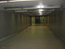 A typical Pedway underground tunnel.
The Chicago Pedway is a network of tunnels, ground-level concourses and overhead bridges connecting skyscrapers, retail stores, hotels and train stations throughout the central business district of Chicago, Illinois. Having a length of more than 40 downtown blocks, it contains shops, restaurants and public art and helps pedestrians traverse this area of the city during inclement weather. Most connections to the pedway are commercial or government buildings. The Heritage at Millennium Park, the Park Millennium, 200 North Dearborn Apartments, and Aqua are currently the only residential buildings connected to the Chicago Pedway.
The oldest portions of the Pedway, aside from the interiors of some included buildings, are the corridors between State and Dearborn Streets, linking Chicago Transit Authority's Red Line and Blue Line stations at Washington/Lake Streets and again at Jackson Street. These were constructed with the subways in 1939-1943; while the completion and outfitting of the Blue Line under Dearborn Street were interrupted by rationing in World War II, the two mezzanine connector tunnels were opened and linked the Red Line under State Street to the sidewalks of Dearborn Street. Construction on the pedway proper began in 1951 and it has continued since then, especially after expansion of it was included in the Chicago 21 Plan introduced in 1973.
The comparatively smaller but more elaborate eastern section of the pedway connecting the Illinois Center buildings, Hyatt Regency, Fairmont Hotel, Swissôtel and (later) Aqua, was not directly accessible from the main (Loop-centric) pedway network, although each linked to one end of the Metra Electric Line rail platform which was controlled by turnstiles and inaccessiable without paying the fare. Since the Regional Transportation Authority's removal of the turnstiles in November 2003, the two large pedway sections have been united by the platform. Conversely, the southern reach of the main network was reduced when the 2nd floor passage across Madison Street, linking Three First National Plaza with Bank One Plaza (now Chase Tower), was removed in after the two buildings instituting security access controls in their lobbies to prevent the public from travelling to the 2nd and higher floors. The tunnels between Chase Tower and Two First National Plaza remain but are closed to the general public. Chase Tower is still connected to the Blue Line subway.
Numerous smaller pedways throughout the central business district are unconnected from the main network. These include the tunnel below Quincy Street and the Dirksen Federal Courthouse, connecting the Red and Blue Lines' Jackson Street stations; the connections within and between the Ogilvie Transportation Center and 2 North Riverside Plaza; the connections within and between the Merchandise Mart and Apparel Center; and the aforementioned passageways under Chase Tower's Exelon Plaza.
Points of entry and exit for the Pedway include:
- One North Dearborn Street
- One North State Street
- 2 North Riverside Plaza
- One Prudential Plaza (130 East Randolph Street)
- Two First National Plaza
- Two Prudential Plaza (180 North Stetson Avenue)
- Three First National Plaza (60 West Dearborn Street)
- 25 East Washington Street
- 77 West Wacker Drive
- 120 North LaSalle
- 139 North Wabash Avenue
- 200 North Dearborn Apartments
- 201 North Clark Street
- 203 North LaSalle Street
- 303 East Wacker Drive
- Aon Center (200 East Randolph Street)
- Aqua
- Block 37 shopping mall at 108 North State Street
- Blue Cross Blue Shield Tower (300 East Randolph Street)
- Boulevard Towers
- Chase Tower
- City Hall/County Building
- Chicago Cultural Center (formerly main library & GAR memorial)
- Chicago Title and Trust Center (181 North Clark Street)
- Columbus Plaza
- Richard J. Daley Bicentennial Plaza
- Richard J. Daley Center (50 West Washington Street)
- In front of the Dirksen Federal Building (interior not connected) (219 South Dearborn Street)
- George W. Dunne Cook County Administration Building (69 West Washington Street)
- Fairmont Hotel Chicago
- Grant Park underground parking garages
- The Heritage at Millennium Park (130 North Garland Court)
- Hyatt Regency Hotel
- Illinois Center
- Lake CTA Red Line station
- Leo Burnett Building (35 West Wacker Drive)
- Macy's in the Marshall Field and Company Building
- Millennium Park
- Ogilvie Transportation Center (500 West Madison Street)
- Millennium Station (formerly Randolph Street Terminal)
- Park Millennium
- Jay Pritzker Pavilion
- Renaissance Chicago Downtown Hotel (formerly Stouffer Riviere)
- Smurfit-Stone Building (150 North Michigan Avenue)
- The Sporting Club
- Sullivan Center (formerly Carson, Pirie, Scott & Co.) (1 South State Street)
- Swissôtel Chicago
- James R. Thompson Center (100 West Randolph)
- Washington CTA Blue Line station
- Washington CTA Red Line station (mothballed indefinitely)
See also
- Underground city
- Block 37
External links
- Chicago Pedway maps made with 2010 City of Chicago data and Pedway segment information at wvaughan.org
- Chicago Pedway map and legend at City of Chicago as a PDF document
- Subterranean City: A Tour of Chicago's Pedway
- Chicago Pedway online map and high quality printable PDF map at spiegl.org
- Chicago Pedway group on Flickr
City of Chicago Chicago metropolitan area · State of Illinois · United States of America Architecture · Beaches · Climate · Colleges and Universities · Community areas · Culture · Demographics · Economy · Flag · Freeways · Geography · Government · History · Landmarks · Literature · Media · Music · Neighborhoods · Parks · Public schools · Skyscrapers · Sports · Theatre · Transportation
 Category ·
  PortalCategories:
- Transportation in Chicago, Illinois
- Skyways
- Underground cities
- Pedestrian infrastructure in the United States
- Homelessness in the United States


Wikimedia Foundation. 2010.