- A11 road (England)
-
For other roads designated "A11", see A11 roads.
A11 road
Major junctions From: London To: Norwich Location Primary
destinations:Stratford
Newmarket
ThetfordRoad network Roads in the United Kingdom
Motorways • A and B road zonesThe A11 is a major road in England. It runs roughly north east from London to Norwich, Norfolk, although after the M11 opened in the 1970s and then the A12 extension in 1999, a lengthy section has been downgraded between the suburbs of east London and the north-west corner of the county of Essex. It also multiplexes/overlaps with the A14 on the Newmarket bypass.
Contents
Route
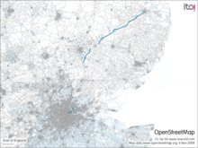 Route of A11 using OpenStreetMap data
City of London
Originally, the A11 started at the Bank of England in the City of London, next to Bank tube station, and went eastwards along Cornhill and Leadenhall Street, past Aldgate Pump and along Aldgate. All this part has been declassified and is now a minor road. Thus the A11 now starts at Aldgate, just inside the eastern boundary of the City of London. The first stretch is Aldgate High Street, passing south of Aldgate tube station. Traffic is one way round the Aldgate one-way system.
Tower Hamlets
East of Aldgate station, the A11 enters the London Borough of Tower Hamlets and the East End of London. It becomes Whitechapel High Street (containing Aldgate East tube station), again part of the Aldgate one-way system. The A11 passes through Whitechapel, past Whitechapel tube station and the Royal London Hospital. It becomes Mile End Road at the eastern end of Whitechapel Road, at Mile End Gate, the former toll gate for the turnpike, passing Stepney Green tube station, with Stepney to the south, and then Mile End tube station. Next, it becomes Bow Road, passing Bow Road tube station and Bow Church DLR station.
There is a dual carriageway flyover over the Bow Interchange roundabout, a junction with the A12. However, at the end of the flyover, the A11 crosses into the London Borough of Newham and becomes a western extension to the A118. Following the opening of the A12 extension in 1999, the A11 was re-numbered to make it seem a less important road and encourage traffic to use the new dual carriageway between there and Leytonstone. This is the western limit of the downgraded section. The A11 number won't reappear until Stump Cross in deepest Essex (see below).
Newham (former A11 section)
The A118 briefly becomes a dual carriageway as it crosses the valley of the River Lea (Originally, there was a strait or narrow ford here, which gave its name to Stratford). This dual carriageway section ends in a one-way system marking Stratford town centre. The eastbound road, Great Eastern Road, passes Stratford station. The westbound road is called Broadway and The Grove; the latter road runs north-south. At the end of the one-way system, The Grove becomes two-way, still going north. The old A11 then becomes Leytonstone Road; Maryland railway station is on the corner where the name change occurs. Meanwhile, the A118 heads eastward along its route towards Ilford and Romford. The A112 also joins the one-way system, heading north-south.
Waltham Forest (former A11 section)
North of Maryland, the old A11 crosses from the London Borough of Newham into the London Borough of Waltham Forest and becomes High Road Leytonstone, passing under the Gospel Oak to Barking Line.
Redbridge (former A11 section)
Once past the Green Man Interchange, the former A11 route enters the London Borough of Redbridge and briefly becomes a southern extension to the A113 before turning into the A1199 (a duplicate designation, given that there is another A1199 in Islington), and is called Hollybush Hill, Woodford Road and High Road Woodford Green. It crosses over the A406 at Gates Corner (named after a Ford car showroom, which was turned into residential flats in 2006), but since the A406 was widened when the M11 was constructed there are no slip roads for interchange and the old A11 passes over the top. It merges with the A104 Woodford New Road by the Statue of Winston Churchill and becomes the A104 High Road Woodford Green. North, the road was A11 until the M11 opened in the 1970s, triggering the downgrading of the A11 between Woodford and Stump Cross (see below). Just before leaving London for Essex, the A104 becomes Epping New Road.
Essex (former A11 section)
Shortly after entering Essex, the A104 enters Epping Forest, following the mainly straight course of the Epping New Road turnpike constructed during the second quarter of the nineteenth century. It then reaches the Wake Arms Roundabout and becomes the B1393. Just after leaving the forest, it crosses the M25 motorway (here lowered into a cut-and-cover tunnel), then continuing through Epping. The B1393 ends at junction 7 of the M11, and the route of the A11 goes along the A414 through the eastern suburbs of Harlow, having been rerouted slightly to the west at the end of the 1950s in order to avoid passing through Potter Street. The road then becomes the A1184 and goes through Sawbridgeworth: through the rest of the Essex stretch between Harlow and Stump Cross the road follows a more traditionally English course, characterized by bends of varying and sometimes uneven radii, with just one straight mile (1.6 km) (to the south of Littlebury) along the north Essex stretch.
Just south of Bishop's Stortford, the A1184 turns sharp left to become part of the Bishop's Stortford bypass, but the route of the A11 becomes the B1383 and goes through the town and through Stansted Mountfitchet and Quendon. It crosses the M11 and passes Audley End. The B1383 ends at 9A (Stump Cross), the end of a spur that comes off the M11 at Junction 9, near Great Chesterford.
Cambridgeshire and Suffolk
The road enters Cambridgeshire, with the road number A11 finally re-appearing at M11 Junction 9A, and the A11 is now a trunk road. It roughly follows the route of a Roman road for the remainder of its length.
The A11 formerly went through Newmarket; that stretch is now the A1304. The Newmarket bypass, opened to traffic in July 1975,[1] is a dual carriageway. The western end is the A11, but most of its length is a multiplex/overlap with the A14. The A11 re-appears north-east of Newmarket, and remains a dual carriageway until Mildenhall, Suffolk. The road bypasses Mildenhall before entering Norfolk in the Thetford Forest, passing the 113-foot / 34 m tall Elveden War Memorial.
Norfolk
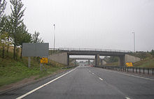
 Thickthorn Interchange between the A47 and A11.
The A11 is then single carriageway to Thetford. The road continues, bypassing Thetford, Attleborough and Wymondham, although up until recently it ran through the centre of Thetford, causing heavy traffic on the route. It also passes the Snetterton Motor Racing Circuit. On entering Norwich, it becomes single carriageway again and is called Newmarket Road. It terminates at the St Stephens Street roundabout near the city centre.
Various sections of the A11 between the junction the M11 in Cambridgeshire and Norwich have recently been upgraded to dual carriageway. The Roudham Heath to Attleborough section was dualled in 2003[2] and the Attleborough bypass was dualed in 2007.[3] A single 16 km stretch of single carriageway now remains, between the Fiveways roundabout near Barton Mills and the start of the Thetford bypass to the south of Thetford.
Proposed improvements
A11 Fiveways - Thetford Improvement
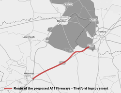
The location of the proposed Fiveways - Thetford ImprovementLocation Norfolk Proposer Highways Agency cost estimate £113-157m (8/08) start date 2010 completion date 2013 Stakeholders Highways Agency Geometry KML Proposals to dual 14.8 km of the road between the Fiveways Roundabout at Barton Mills, bypassing Elveden to the North and joining the western end of the Thetford Bypass are well advanced.[4] Draft Orders together with Environmental Statement were published in Autumn 2008 however dates for the pre-inquiry and the public inquiry have yet to be announced.[5] The Labour government's Secretary of State for Transport announced the scheme would be bought forward by 18 months to 2010 with an open date of 2013 in November 2008 in response to the Financial crisis of 2007-2008.[6] Supporters expressed concern in September 2010 that the scheme would be cancelled as part of the coalition government's comprehensive spending review noting that the report from the public inquiry had not yet been signed off by the Department for Transport.[7]
The Highways Agency has published an official map of the proposed scheme and a Google overlay map is also available. The original cost estimate was £30 million rising to £60 million in March 2007[8] and then to £113-£157 million by August 2008.[9]
The project has received strong support from local business groups and local government[9] and is expected to reduce journey times by 3 minutes off-peak and up to 25 minutes at peak times.[10] Environmental campaign groups believe that in a time of economic downturn it would be better to invest in local public transport rather than on costly road schemes.[11] On 20th October 2010, the government gave the green light, indicating that the works will continue.[12]
References
- ^ "News: And Newmarket by-pass". Autocar 143 (nbr 4105): page 27. date 12 July 1975.
- ^ "A11 Roudham Heath to Attleborough Dualling". Highways Agency. http://www.highways.gov.uk/roads/projects/4259.aspx. Retrieved 2008-11-05.
- ^ "A11 Attleborough Bypass Improvement". Highways Agency. http://www.highways.gov.uk/roads/projects/4253.aspx. Retrieved 2008-11-05.
- ^ "A11 Fiveways - Thetford Improvement". Highways Agency. http://www.highways.gov.uk/roads/projects/4248.aspx. Retrieved 2009-07-23.
- ^ "A11 Fiveways to Thetford Improvement - Project timeline". Highways Agency. http://www.highways.gov.uk/roads/projects/24040.aspx. Retrieved 2009-07-23.
- ^ "Major boost for East of England as planned A11 dualling brought forward". Department for Transport (East). http://nds.coi.gov.uk/Content/Detail.asp?ReleaseID=384459&NewsAreaID=2. Retrieved 2008-11-18.[dead link]
- ^ "MPs from Norfolk and Suffolk fight to keep A11 funding". BBC News. 2010-09-24. http://www.bbc.co.uk/news/uk-england-11407737. Retrieved 2010-09-25. "MPs have called on businesses, residents and councils to lobby government ministers to remind them of the importance of widening the A11"
- ^ "Estimating and monitoring the costs of building roads in England". National Audit Office. http://www.nao.org.uk//idoc.ashx?docId=11875A43-E927-4BD3-A4A5-5423394EA529&version=-1. Retrieved 2009-07-23.
- ^ a b "Government told it's high time to dual the A11 as public petition launched by Norfolk County Council". Norfolk county council. http://www.norfolk.gov.uk/consumption/idcplg?IdcService=SS_GET_PAGE&ssDocName=NCC060408&ssSourceNodeId=&ssTargetNodeId=3018. Retrieved 2008-11-05.
- ^ "Why dualling the A11 makes business sense". BIZonline. http://business.edp24.co.uk/members/editorial/coverStory/story.aspx?brand=BIZOnline&category=Features&tBrand=BIZOnline&tCategory=Features&itemid=NOED24%20Sep%202008%2008%3A55%3A36%3A477. Retrieved 2008-11-05.[dead link]
- ^ "Road building won't stop the recession". Campaign for Better Transport (CBT). http://www.bettertransport.org.uk/node/1579. Retrieved 2008-11-18.
- ^ "A11 dualling set to be given go-ahead". Eastern Daily Press (Norfolk, UK). http://www.edp24.co.uk/news/a11_dualling_set_to_be_given_go_ahead_1_685736. Retrieved 2010-10-20.
External links
- Society for All British Road Enthusiasts entry for the A11
- A11 (M11 to Norwich)
- Highways Agency - A11 Strategy: Cambridge to Norwich
- GatewayA11East
- Road to Nowhere - A11
A roads in Zone 1 of the Great Britain road numbering scheme 
A100 · A101 · A102 · A103 · A104 · A105 · A106 · A107 · A109 · A110 · A111 · A114 · A116 · A118 · A119 · A120 · A121 · A124 · A127 · A128 · A129 · A130 · A131 · A132 · A133 · A134 · A135 · A140 · A143 · A144 · A145 · A146 · A148 · A149 · A151 · A152 · A153 · A156 · A157 · A158 · A159 · A160 · A165 · A167 · A168 · A170 · A171 · A172 · A173 · A174 · A177 · A178 · A179 · A180 · A182 · A183 · A186 · A189 · A194 · A197
Roads in London Roads MotorwaysRing roadsMajor roadsOther Categories:- Transport in the City of London
- Transport in Newham
- Transport in Redbridge
- Transport in Tower Hamlets
- Transport in Waltham Forest
- Roads in England
- Transport in Cambridgeshire
- Transport in Essex
- Roads in London
- Transport in Norfolk
- Transport in Suffolk


Wikimedia Foundation. 2010.