- Ombersley
-
Coordinates: 52°16′17″N 2°13′43″W / 52.271302°N 2.228711°W
Ombersley 
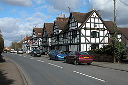
The Kings Arms, Ombersley
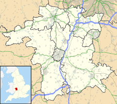
 Ombersley shown within Worcestershire
OS grid reference SO844635 - London 103 Miles District Wychavon Shire county Worcestershire Region West Midlands Country England Sovereign state United Kingdom Post town DROITWICH Postcode district WR9 Dialling code 01905 Police West Mercia Fire Hereford and Worcester Ambulance West Midlands EU Parliament West Midlands UK Parliament Mid Worcestershire List of places: UK • England • Worcestershire The village of Ombersley is in the Wychavon District Council area of Worcestershire. The first known reference to the village[1] was the granting of a Charter to Abbot Egwin, later Saint Egwin, of Evesham Abbey in 706 AD. This was the Charter of King Æthelweard of the Hwicce, which granted twelve cassates in Ombersley to the Benedictine Abbey at Evesham.[2]
Contents
Location
O.S. Ref: SO844635 6 miles north of Worcester, 4 miles west of Droitwich, on the intersection of the A449 & A4133
References
- ^ Article about Ombersley, The Birmingham Post (May 2006)
- ^ University of London & History of Parliament Trust (2003-2007). "Houses of Benedictine monks - Abbey of Evesham". British History Online. http://www.british-history.ac.uk/report.asp?compid=36469#n9. Retrieved 2007-04-01.
Further reading
- 'Parishes: Ombersley', A History of the County of Worcester: volume 3 (1913), pp. 460-468.
- Staff. Ombersley Conservation Area Appraisal Wychavon District Council, June 2005
External links
Categories:- Villages in Worcestershire
- Worcestershire geography stubs
Wikimedia Foundation. 2010.

