- Drakes Broughton
-
Coordinates: 52°08′02″N 2°06′34″W / 52.133821°N 2.109466°W
Drakes Broughton 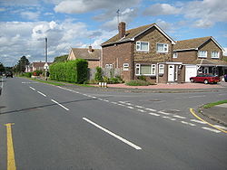
 Drakes Broughton
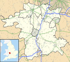
Drakes Broughton shown within WorcestershireDistrict Wychavon Shire county Worcestershire Region West Midlands Country England Sovereign state United Kingdom Post town Pershore Postcode district WR10 EU Parliament West Midlands List of places: UK • England • Worcestershire Drakes Broughton is a village in Worcestershire, England.
The village is situated on the B4084 road (previously the A44) 2 miles north of Pershore and 7 miles south of Worcester.
The village has two pubs; the Old Oak and the Plough and Harrow.
Its school, St Barnabas, has both a First School and a Middle School, which then feeds into Pershore High School in nearby Pershore
Drakes Broughton has a recreation ground, on which the village’s cricket and football teams (www.drakesbroughtonrangersfc.co.uk) play. The recreation ground stands alongside the village's church, St Barnabas, and the village hall (www.dbvh.btik.com)
Drakes Broughton has a chip shop, two general stores, a motorcycling shop, nursery and a hairdresser. It is a rather uncomely village for the surrounding area of natural beauty.
Categories:- Villages in Worcestershire


Wikimedia Foundation. 2010.