Martin Hussingtree

Martin Hussingtree

Coordinates: 52°14′23″N 2°10′23″W / 52.239611°N 2.17318°W / 52.239611; -2.17318

Martin Hussingtree
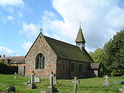
St Michael & All Angels, Martin Hussingtree - geograph.org.uk - 92936.jpg
St Michael & All Angels, Martin Hussingtree
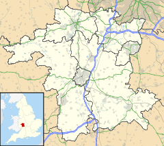
Martin Hussingtree is located in Worcestershire
Martin Hussingtree

 Martin Hussingtree shown within Worcestershire
OS grid reference SO882601
District Wychavon
Shire county Worcestershire
Region West Midlands
Country England
Sovereign state United Kingdom
Post town WORCESTER
Postcode district WR3
Dialling code 01905
Police West Mercia
Fire Hereford and Worcester
Ambulance West Midlands
EU Parliament West Midlands
List of places: UK • England • Worcestershire

Martin Hussingtree is a small village situated between Droitwich Spa and Worcester in the county of Worcestershire, England. It is north of another village called Fernhill Heath. It is situated on a junction of the A38 and A4538. There is a public house called "The Swan" in the village and is located just north of the junction.

Its church contains the grave of Thomas Tomkins, a composer of sacred music under Elizabeth I and James I.

External links


Wikimedia Foundation. 2010.

Игры ⚽ Поможем написать курсовую

Look at other dictionaries:

  • Martin — For people with the surname or given name Martin or similar, see Martin (name). Martin may refer to: Contents 1 Places 1.1 In Europe 1.2 …   Wikipedia

  • A38 road — A38 road …   Wikipedia

  • Thomas Tomkins — (* 1572 in St Davids, Wales; † 1656 in Martin Hussingtree, Worcestershire) war ein britischer Komponist. Leben und Werk Thomas Tomkins gilt als das berühmteste Mitglied einer namhaften englischen Musikerfamilie. Vermutlich wurde er im Jahre 1578… …   Deutsch Wikipedia

  • Droitwich Spa — Coordinates: 52°16′01″N 2°09′11″W / 52.267°N 2.153°W / 52.267; 2.153 …   Wikipedia

  • Overbury — Coordinates: 52°02′16″N 2°03′35″W / 52.03769°N 2.05973°W / 52.03769; 2.05973 …   Wikipedia

  • Abbots Morton — Coordinates: 52°11′38″N 1°57′38″W / 52.194°N 1.9606°W / 52.194; 1.9606 …   Wikipedia

  • List of civil parishes in Worcestershire — Bromsgrove= Bromsgrove and Rubery are unparished.*Alvechurch *Barnt Green *Belbroughton *Bentley Pauncefoot *Beoley *Bournheath *Catshill and North Marlbrook *Clent *Cofton Hackett *Dodford with Grafton *Finstall *Frankley *Lickey and Blackwell… …   Wikipedia

  • Ombersley — Coordinates: 52°16′17″N 2°13′43″W / 52.271302°N 2.228711°W / 52.271302; 2.228711 …   Wikipedia

  • Mere Green, Worcestershire — Coordinates: 52°15′35″N 2°04′24″W / 52.25974°N 2.07321°W / 52.25974; 2.07321 …   Wikipedia

  • Netherton, Worcestershire — Coordinates: 52°04′20″N 2°00′52″W / 52.072358°N 2.014575°W / 52.072358; 2.014575 …   Wikipedia

Share the article and excerpts

Direct link
Do a right-click on the link above
and select “Copy Link”