- Oettingen in Bayern
-
Oettingen in Bayern 

 Oettingen in BayernLocation of the town of Oettingen in Bayern within Donau-Ries district
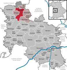
Coordinates 48°57′N 10°35′E / 48.95°N 10.58333°ECoordinates: 48°57′N 10°35′E / 48.95°N 10.58333°E Administration Country Germany State Bavaria Admin. region Swabia District Donau-Ries Municipal assoc. Oettingen in Bayern Town subdivisions 5 Stadtteile Mayor Matti Müller (SPD) Basic statistics Area 34.21 km2 (13.21 sq mi) Elevation 418 m (1371 ft) Population 5,028 (31 December 2010)[1] - Density 147 /km2 (381 /sq mi) Other information Time zone CET/CEST (UTC+1/+2) Licence plate DON Postal codes 86729–86732 Area code 09082 Website www.oettingen.de County (Principality) of Oettingen
Grafschaft (Fürstentum) OettingenState of the Holy Roman Empire ← 
1147–1806  →
→
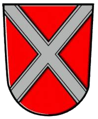
Coat of arms
Capital Oettingen in Bayern Government Principality Historical era Middle Ages - First documentary
mention
1147- Partitioned 1418, 1442 and 1485 - Partitioned to
Ö-Oettingen and
Ö-Wallerstein
1522- Ö-Wallerstein
partitioned to create
Ö-Baldern and
Ö-Spielberg
1623/94- Ö-Oettingen extinct,
to Ö-Spielberg
and Ö-Wallerstein
1731- Ö-Spielberg and
Ö-Wallerstein raised
to principalities
1734 and 1774- Ö-Baldern extinct,
to Ö-Wallerstein
1798- Mediatised to Bavaria 1806 Oettingen in Bayern is a town in the Donau-Ries district, in Bavaria, Germany. It is situated 29 km (18 mi) northwest of Donauwörth, and 14 km (8.7 mi) northeast of Nördlingen.
Contents
Geography
The town is located on the Wörnitz, a branch of the Danube, and lies on the northern edge of the Nördlinger Ries, a gigantic crater 25 km (16 mi) in diameter.
Stadtgliederung:
- Erlbach
- Heuberg
- Lehmingen
- Niederhofen
- Nittingen
- Oettingen
Industry
The Oettinger Brewery, who make Germany's best-selling brand of beer, has its main brewery and headquarters in Oettingen.
History
Neolithic findings indicate that the region was settled around 5000 BC. Archaeologists have also discovered the remains of a Bronze Age settlement and a Roman village. Oettingen was largely destroyed by an Allied bombing raid in January 1945.
Culture and Points of Interest
- Königsturm (lit. King's Tower)
- The tower of the lower gate, the so called King's Tower, is the only one along the city fortifications to have been preserved. The lower outskirts used to be located on the outside, and were secluded by an exterior lower gate. The lower level still exhibits remains of the tower from the thirteenth century. The city governors together with the citizens constructed a new tower in 1594–96. Cells from the city jail remain on the inside.
- Rathaus (City Hall)
- The city hall is one of the most outstanding examples of the Swabian Fachwerk style. The stone entry level and portal were built in 1431 while the upper floors and the impressive roof framework come from 1480. The nearby civic house from the seventeenth century was connected to the city hall during renovations (1986–93). The city hall today is the seat of municipal government and governing body of Oettingen, and the city license bureau is found on the ground floor.
- Marktplatz (Marketplace)
- The marketplace forms the centre of Oettingen, and the weekly farmers market takes place here on Fridays. Worth noting is the architectural layout: on the east side, the gables are Baroque-style, and on the west side, they are Fachwerk-style.
- The Storks of Oettingen
- Storks have been nesting in Oettingen at least since the time of Count Ludwig XVI (more than 400 years ago), and Ludwig was supposedly a friend of the storks. According to legend, when the Count left the town after the Schmalkaldic War, the storks also moved away and never came back. It wasn't until much later in 1563 when the count came back that the storks, too, wandered back into the town and have remained there up to this day.
- Altes Gymnasium (Old High School)
- The building was built in 1724 under the direction of Albert Ernest II by Johann Christian Lüttich. It accommodated the Latin School which was established in 1563, and served to educate the children of the parish and of the city governors.
See also
- House of Oettingen-Oettingen
- House of Oettingen-Spielberg
- House of Oettingen-Wallerstein
References
- ^ "Fortschreibung des Bevölkerungsstandes" (in German). Bayerisches Landesamt für Statistik und Datenverarbeitung. 31 December 2010. https://www.statistikdaten.bayern.de/genesis/online?language=de&sequenz=tabelleErgebnis&selectionname=12411-009r&sachmerkmal=QUASTI&sachschluessel=SQUART04&startjahr=2010&endjahr=2010.
External links
Alerheim | Amerdingen | Asbach-Bäumenheim | Auhausen | Buchdorf | Daiting | Deiningen | Donauwörth | Ederheim | Ehingen am Ries | Forheim | Fremdingen | Fünfstetten | Genderkingen | Hainsfarth | Harburg | Hohenaltheim | Holzheim | Huisheim | Kaisheim | Maihingen | Marktoffingen | Marxheim | Megesheim | Mertingen | Mönchsdeggingen | Monheim | Möttingen | Munningen | Münster | Niederschönenfeld | Nördlingen | Oberndorf am Lech | Oettingen in Bayern | Otting | Rain | Reimlingen | Rögling | Tagmersheim | Tapfheim | Wallerstein | Wechingen | Wemding | Wolferstadt Categories:
- Towns in Bavaria
- Former principalities
- Former countries in Europe
- States of the Holy Roman Empire
- States and territories established in 1147
- States and territories disestablished in 1806
- Historic Jewish communities
- Donau-Ries


Wikimedia Foundation. 2010.