- Waldburg
-
For the town in Upper Austria, see Waldburg, Austria.
Waldburg 
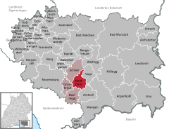
Coordinates 47°45′25″N 9°42′46″E / 47.75694°N 9.71278°ECoordinates: 47°45′25″N 9°42′46″E / 47.75694°N 9.71278°E Administration Country Germany State Baden-Württemberg Admin. region Tübingen District Ravensburg Municipal assoc. Gullen Mayor Michael Röger Basic statistics Area 22.70 km2 (8.76 sq mi) Elevation 723 m (2372 ft) Population 3,051 (31 December 2010)[1] - Density 134 /km2 (348 /sq mi) Other information Time zone CET/CEST (UTC+1/+2) Licence plate RV Postal code 88289 Area code 07529 Website www.gemeinde-waldburg.de County of Waldburg
Grafschaft WaldburgState of the Holy Roman Empire 12th century–1424  →
→
 →
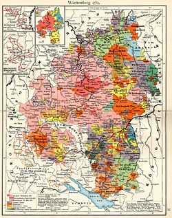
→The County of Waldburg, shown in green at the bottom right, within Württemberg Capital Waldburg Language(s) Alemannic German Government Principality Historical era Middle Ages - Established 12th century - First comital line extinct 1183 - Partitioned 1424 Waldburg is a town in the district of Ravensburg in Baden-Württemberg in Germany. Most notably is the medieval castle that sits atop the large hill in the town. Waldburg castle dates from the twelfth century, when Waldburg was a County of the Holy Roman Empire.
House of Waldburg
Main article: House of WaldburgIn 1424, the county was partitioned:
- Waldburg-Sonnenburg, annexed by Austria, 1511
- Waldburg-Trauchburg, partitioned in 1504:
- Waldburg-Capustigall, annexed by Prussia, 1745
- Waldburg-Trauchburg, partitioned in 1612:
- Waldburg-Friedburg-Scheer, restored in 1717
- Waldburg-Trauchburg, partitioned in 1717:
- Waldburg-Scheer, restored in 1764
- Waldburg-Trauchburg, annexed by Waldburg-Zeil, 1772
- Waldburg-Wolfegg-Zeil, partitioned in 1589:
- Waldburg-Waldburg, divided between Waldburg-Wolfegg and Waldburg-Zeil in 1660
- Waldburg-Wolfegg, partitioned in 1667:
- Waldburg-Waldsee, raised to principality in 1803, mediatised to Württemberg in 1806
- Waldburg-Wolfegg, annexed by Waldburg-Waldsee in 1798
- Waldburg-Zeil, partitioned in 1674:
- Waldburg-Wurzach, raised to principality in 1803, mediatised to Württemberg in 1806
- Waldburg-Zeil, raised to principality in 1803, mediatised to Württemberg in 1806
Achberg | Aichstetten | Aitrach | Altshausen | Amtzell | Argenbühl | Aulendorf | Bad Waldsee | Bad Wurzach | Baienfurt | Baindt | Berg | Bergatreute | Bodnegg | Boms | Ebenweiler | Ebersbach-Musbach | Eichstegen | Fleischwangen | Fronreute | Grünkraut | Guggenhausen | Horgenzell | Hoßkirch | Isny im Allgäu | Kißlegg | Königseggwald | Leutkirch im Allgäu | Ravensburg | Riedhausen | Schlier | Unterwaldhausen | Vogt | Waldburg | Wangen im Allgäu | Weingarten | Wilhelmsdorf | Wolfegg | WolpertswendeReferences
- ^ "Bevölkerung und Erwerbstätigkeit" (in German). Statistisches Landesamt Baden-Württemberg. 31 December 2009. http://www.statistik-bw.de/Veroeffentl/Statistische_Berichte/3126_10001.pdf.
Categories:- Geography articles needing translation from German Wikipedia
- Municipalities in Baden-Württemberg
- Former principalities
- Former countries in Europe
- States of the Holy Roman Empire
- States and territories established in the 12th century
- States and territories disestablished in 1424
- 1424 disestablishments
- Ravensburg district
- House of Waldburg
- Tübingen region geography stubs
Wikimedia Foundation. 2010.


