- Flood control in the Netherlands
-
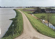
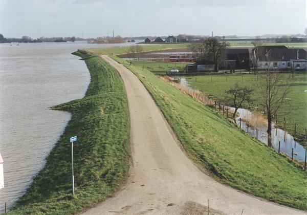
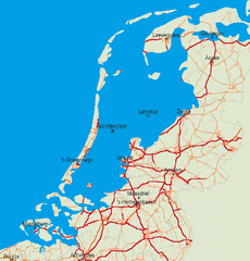 Without dikes, this part of the Netherlands would be flooded
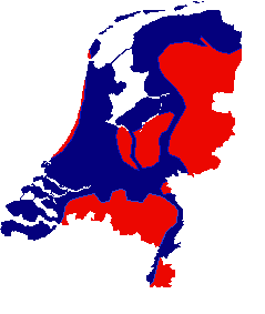
 Blue: Areas vulnerable to flooding
Flood control in the Netherlands is an important issue for the Netherlands as about two thirds of the country is vulnerable to flooding while at the same time the country is among the most densely populated on earth. Natural sand dunes and man made dikes, dams and floodgates provide defense against storm surges from the sea. River dikes prevent flooding from water flowing into the country by the major rivers Rhine and Meuse, while a complicated system of drainage ditches, canals and pumping stations (historically: windmills) keep the low lying parts dry for habitation and agriculture. Water control boards are the independent local government bodies responsible for maintaining this system.
In modern times flood disasters coupled with technological development have led to large construction works to reduce the influence of the sea and prevent future floods.
Contents
History
Original geography of the Netherlands and terp building
Main article: Geography of the NetherlandsThe flood threatened area of the Netherlands is essentially an alluvial plain, built up from sediment left by thousands of years of flooding by rivers and sea. About 2000 years ago, before the intervention of man, most of the Netherlands were covered by extensive peat swamps. The coast was formed by a row of coastal dunes and natural embankments which kept the swamps from draining but also from being washed away by the sea. The only areas suitable for habitation were on the higher grounds in the east and south and on the dunes and natural embankments along the coast and the rivers. In several places the sea had broken through these natural defenses and created extensive floodplains in the north. The first permanent inhabitants of this area were probably attracted by the sea deposited clay soil which was much more fertile than the peat and sandy soil further inland. To protect themselves against floods they built their homes on Artificial dwelling hills called terpen or wierden (known as Warft or Hallig in Germany). Between 500 BC and 700 AD there were probably several periods of habitation and abandonment as the sea level periodically rose and fell.
Dike construction in coastal areas
The first dikes were low embankments of only a meter or so in height surrounding fields to protect the crops against occasional flooding. Around the 9th century the sea was on the advance again and many terps had to be raised to keep them safe. Many single terps had by this time grown together as villages. These were now connected by the first dikes.
After 1000 AD the population grew which meant there was a greater demand of arable land but also that there was a greater workforce available and dike construction was taken up more seriously. Major contributors in later dike building were monasteries. As the largest landowners they had the organization, resources and manpower to undertake these large construction works. By 1250 most dikes had been connected into a continuous sea defense.
The next step was to move the dikes ever more seawards. Every cycle of high and low tide left a small layer of sediment. Over the years these built up to such a height that it was rarely flooded. It was then considered safe to build a new dike around this area. The old dike was often kept as a secondary defense, called sleeper dike.
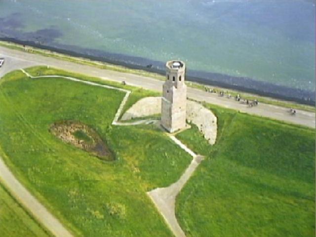
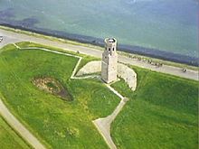 The Plompe toren, the only remainder of the village Koudekerke
A dike couldn't always be moved seawards. Especially in the southwest river delta it was often the case that the primary sea dike was undermined by a tidal channel. A secondary dike was then built, called inlaagdijk. With an inland dike, when the seaward dike collapsed the secondary inland dike becomes the primary. Although the redundancy provides security, the land from the first to second dike is lost- over the years the loss can become significant.
Taking land from the cycle of flooding by putting a dike around it prevents it from being raised by silt left behind after a flooding. At the same time the drained soil consolidates and peat decomposes leading to land subsidence. In this way the difference between the water level on one side and land level on the other side of the dike grew. While floods became more rare, if the dike did overflow or was breached the destruction was much larger.
The construction method of dikes has changed over the centuries. Popular in the Middle Ages were 'wierdijken', earth dikes with a protective layer of seaweed. An earth embankment was cut vertically on the sea facing side. Seaweed was then stacked against this edge, held into place with poles. Compression and rotting processes resulted in a solid residue that proved very effective against wave action and needed only very little maintenance. In places where seaweed was unavailable other materials such as reeds or wicker mats were used.
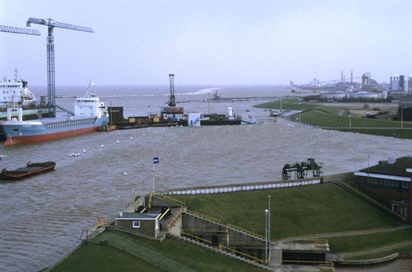
 Sea dike keeping Delfzijl and surroundings dry in 1994
Another system used much and for a long time was that of a vertical screen of timbers backed by an earth bank. Technically these vertical constructions were less successful as vibration from crashing waves and washing out of the dike foundations weakened the dike.
Much damage was done to these wood constructions with the arrival of the shipworm (Teredo navalis), a little creature thought to have been brought to the Netherlands by VOC trading ships, that ate its way through Dutch sea defenses around 1730. The change was made from wood to using stone for reinforcement. This was a great financial setback as there is no natural occurring rock in the Netherlands and it all had to be imported from abroad.
Current dikes are made with a core of sand, covered by a thick layer of clay to provide waterproofing and resistance against erosion. Dikes without a foreland have a layer of crushed rock below the waterline to slow wave action. Up to the high waterline the dike is often covered with carefully laid basalt stones or a layer of tarmac. The remainder is covered by grass and maintained by grazing sheep. Sheep keep the grass dense and compact the soil, in contrast to cows.
Developing the peat swamps
At about the same time as the building of dikes the first swamps were made suitable for agriculture by colonists. By digging a system of parallel drainage ditches water was drained from the land to be able to grow grain. However the peat settled much more than other soil types when drained and land subsidence resulted in developed areas becoming wet again. Cultivated lands which were at first primarily used for growing grain thus became too wet and the switch was made to dairy farming. A new area behind the existing field was then cultivated, heading deeper into the wild. This cycle repeated itself several times until the different developments met each other and no further undeveloped land was available. All land was then used for grazing cattle.
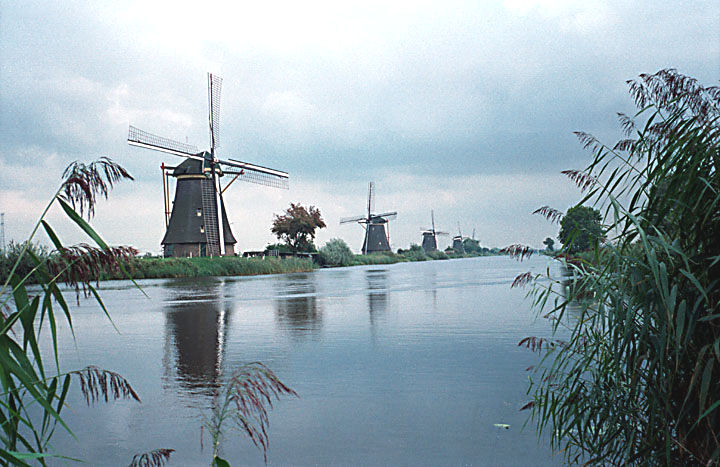
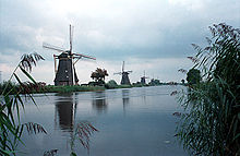 The windmills of Kinderdijk, the Netherlands
Because of the continuous land subsidence it became ever more difficult to remove excess water. The mouths of streams and rivers were dammed to prevent high water levels flowing back upstream overflowing cultivated lands. These dams had a wooden culvert equipped a valve, allowing drainage but preventing water from flowing upstream. These dams however blocked shipping and the economic activity caused by the necessity to transship goods caused villages grow up near the dam, some famous examples are Amsterdam (dam in the river Amstel) and Rotterdam (dam in the Rotte). Only in later centuries were locks developed to allow ships to pass.
Further drainage could only be accomplished after the development of the polder windmill in the 15th century. The winddriven waterpump has become one of the trademark tourist attraction of the Netherlands. The first polder mills using a waterwheel could raise water at most 1 meter. By combining mills the pumping height could be increased. Later mills were equipped with an Archimedes' screw which could raise water much higher. The polders, now often below sea level, were kept dry with polder mills which pumped water from the polder ditches and canals to the boezem, a system of canals and lakes connecting the different polders and acting as a storage basin until the water could be let out to river or sea, either by a sluice gate at low tide or using further pumps. This system is still in use today, though polder mills have been replaced by first steam and later diesel and electric pumping stations.
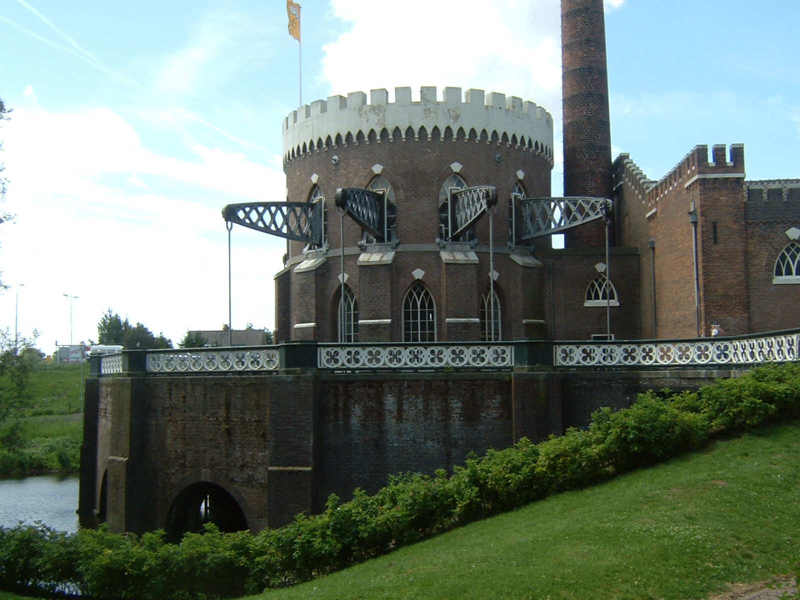
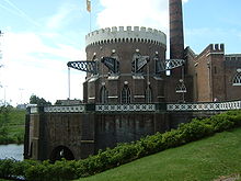 De Cruquius is one of the three pumping stations that drained the Haarlemmermeer
The growth of towns in the Middle Ages resulted in an increased demand for dried peat as fuel. First all the peat down to the groundwater table was dug away. In the 16th century a method was developed to dig peat below water, using a dredging net on a long pole. Large scale peat dredging was taken up by companies, supported by investors from the cities. These undertakings often devastated the landscape as agricultural land was dug away and the leftover ridges, used for drying the peat, collapsed under the action of waves. Small lakes were created which quickly grew in size, every increase in surface water leading to more leverage of the wind on the water to attack more land. It even led to villages being lost to the waves of man-made lakes. The development of the polder mill gave the option of draining the lakes. In the 16th century this work was started on small, shallow lakes, continuing with ever larger and deeper lakes, though it wasn't until in the nineteenth century that the most dangerous of lakes, the Haarlemmermeer near Amsterdam, was drained using steam power. Drained lakes can often be easily recognised on topographic maps by their different regular division pattern as compared to their older surroundings.
See also: Jan LeeghwaterControl of river floods
Three major European rivers, the Rhine, Meuse and Scheldt flow through the Netherlands of which the Rhine and Meuse cross the country from east to west.
The first large construction works on the rivers were conducted by the Romans. Nero Claudius Drusus was responsible for building a dam in the Rhine to divert water from the river branches Waal to the Nederrijn and possibly for connecting the river IJssel, previously only a small stream, to the Rhine. Whether these were intended as flood control measures or just for military defense and transportation purposes is unclear.
The first river dikes appeared near the river mouths in the 11th century, where incursions from the sea added to the danger from high water levels on the river. Local rulers dammed branches of rivers to prevent flooding on their lands (Graaf van Holland, +-1160, Kromme Rijn; Floris V, 1285, Hollandse IJssel), only to cause problems to others living further upstream. Large scale deforestation upstream caused the river levels to become ever more extreme while the demand for arable land led to more land being protected by dikes, giving less space to the river stream bed and so causing even higher water levels. Local dikes to protect villages were connected to create a ban dike to contain the river at all times. These developments meant that while the regular floods for the first inhabitants of the river valleys were just a nuisance, in contrast the later incidental floods when dikes burst were much more destructive.
 The Nederrijn in 1995
The 17th and 18th century was a period of many infamous river floods resulting in much loss of life. They were often caused by ice dams blocking the river. Land reclamation works, large willow plantations and building in the winter bed of the river all worsened the problem. Next to the obvious clearing of the winter bed, overflows (Dutch: overlaten) were created. These were intentionally low dikes where the excess water could be diverted downstream. The land in such a diversion channel was kept clear of buildings and obstructions. As this so called green river could therefore essentially only be used for grazing cattle it was in later centuries seen as a wasteful use of land. Most overflows have now been removed, focusing instead of stronger dikes and more control over the distribution of water across the river branches. To achieve this canals such as the Pannerdens Kanaal and Nieuwe Merwede were dug.
A committee reported in 1977 about the weakness of the river dikes but there was too much resistance from the local population against demolishing houses and straightening and strengthening the old meandering dikes. It took the flood threats in 1993 and again in 1995, when over 200.000 people had to be evacuated and the dikes only just held, to put plans into action. Now the risk of a river flooding has been reduced from once every 100 years to once every 1250 years.
Water control boards
Main article: Water board (The Netherlands)The first dikes and water control structures were built and maintained by those directly benefiting from them, mostly farmers. As the structures got more extensive and complex councils were formed from people with a common interest in the control of water levels on their land and so the first water boards began to emerge. These often controlled only a small area, a single polder or dike. Later they merged or an overall organization was formed when different water boards had conflicting interests. The original water boards differed much from each other in organisation, power and area they managed. The differences were often regional and dictated by differing circumstances, whether they had to defend a sea dike against a storm surge or keep the water level in a polder within bounds. In the middle of the twentieth century there were about 2700 water control boards. After many mergers there are currently 27 water boards left. Water boards hold separate elections, levy taxes and function independently from other government bodies.
The dikes were maintained by the individuals who benefited from their existence, every farmer having been designated part of the dike to maintain, with a three-yearly viewing by the water board directors. The old rule "Who the water hurts, who the water stops" (Dutch: Wie het water deert, die het water keert) meant that those living at the dike had to pay and care for it. This led to haphazard maintenance and it is believed that many floods would not have happened or would not have been as severe if the dikes had been in better condition.[1] Those living further inland often refused to pay or help in the upkeep of the dikes though they were just as much affected by floods while those living at the dike itself could go bankrupt from having to repair a breached dike.
Rijkswaterstaat (English: Directorate General for Public Works and Water Management) was set up in 1798 under French rule to put water control in the Netherlands under a central government. Local waterboards however were too attached to their autonomy and for most of the time Rijkswaterstaat worked alongside the local waterboards. Rijkswaterstaat has been responsible for many major water control structures and was later and still is also involved in building railroads and highways.
Notorious floods
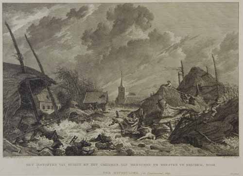
Main article: Floods in the Netherlands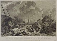 A flood at Erichem, 1809
Over the years there have been many storm surges and floods in the Netherlands. Some deserve special mention as they particularly have changed the contours of the Netherlands.
A series of devastating storm surges, more or less starting with the First All Saints' flood (Dutch: Allerheiligenvloed) in 1170 washed away a large area of peat marshes, enlarging the Wadden Sea and connecting the previously existing lake Almere in the middle of the country to the North Sea, thereby creating the Zuiderzee. It in itself would cause much trouble until the building of the Afsluitdijk in 1933.
Several storms starting in 1219 created the Dollart from the mouth of the river Ems. By 1520 the Dollart had reached it largest size. Reiderland, containing several towns and villages, was lost. Much of this land was later reclaimed.
In 1421 the St. Elizabeth's flood caused the loss of 'De Grote Waard' in the south west of the country. Particularly the digging of peat near the dike for salt production and neglect because of a civil war caused dikes to fail. It created the Biesbosch, a valued nature reserve.
The more recent floodings of 1916 and 1953 gave rise to building the Afsluitdijk and Deltaworks respectively.
Flooding as military defense
By flooding certain areas on purpose a military defensive line could be created. In case of an advancing enemy army the area was inundated with about 30 cm (1 foot) of water, too shallow for boats but deep enough to make advance on foot difficult, hiding underwater obstacles as canals, ditches and purpose-built traps. Dikes crossing the flooded area and other strategic points were protected by fortifications. The system proved successful on the Dutch Water Line in the 1672 during the Third Anglo-Dutch War but was overcome in 1795 because of heavy frost. It was also used with the Stelling van Amsterdam, the Grebbe line and the IJssel line. The advent of heavier artillery and especially airplanes have made this strategy largely obsolete.
Modern developments
Technological development in the twentieth century meant that larger projects could be undertaken to further improve the safety against flooding and to reclaim large areas of land. The most important are the Zuiderzee Works and the Delta Works. By the end of the twentieth century all sea inlets have been closed off from the sea by dams and barriers. Only the Westerschelde needs to remain open for shipping access to the port of Antwerp. Plans to reclaim (parts of) the Wadden Sea and the Markermeer were eventually called off because of the ecological and recreational values of these waters.
Zuiderzee Works
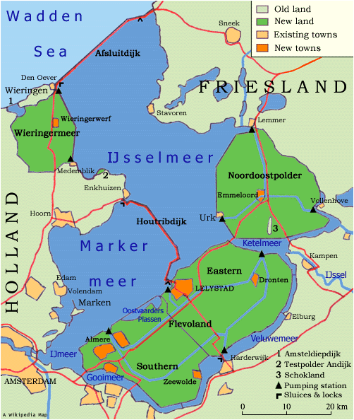
Main article: Zuiderzee Works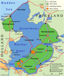 The Zuiderzee Works turned the Zuiderzee into a fresh water lake IJsselmeer, and created 1650 km² of land.
The Zuiderzee Works (Zuiderzeewerken) are a man-made system of dams, land reclamation and water drainage works. The basis of the project was the damming off of the Zuiderzee, a large shallow inlet of the North Sea. This dam is called the Afsluitdijk. It was built in 1932-1933. The dam closed the Zuiderzee and separated it from the North Sea. As result, the Zuider sea became the IJsselmeer — IJssel lake.
Following the damming, large areas of land were reclaimed in the newly freshwater lake body by means of polders. The works were performed in several steps from 1920 to 1975.
See also: Cornelis LelyDelta Works
Main article: Delta Works Oosterscheldekering at work during a storm.
A study done by Rijkswaterstaat in 1937 showed that the sea defenses in the southwest river delta were inadequate to withstand a major storm surge. The proposed solution was to dam all the river mouths and sea inlets thereby shortening the coast. However because of the scale of this project and the intervention of the Second World War its construction was delayed and the first works were only completed in 1950. The North Sea flood of 1953 gave a major impulse to speed up the project. In the following years a number of dams were built to close off the estuary-mouths. In 1976, under pressures from environmental groups and the fishing industry, it was decided not to close off the Oosterschelde estuary by a solid dam but instead to build the Oosterscheldekering, a storm surge barrier which is only closed during storms. It is the most well-known (and most expensive) dam of the project. The project was finished with the construction of the Maeslantkering in 1997.
Current situation and future
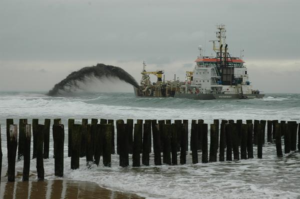
 Sand replenishment in front of a Dutch beach
The current sea defenses are stronger than ever but experts warn that complacency would be a mistake. New calculation methods revealed numerous weak spots. Further, sea level rise (made more extreme by global warming) and continuing land subsidence will make further upgrades to the flood control and water management infrastructure necessary.
The sea defenses are continuously being strengthened and raised to meet the safety norm of a flood chance of once every 10.000 years for the west, this being the economic heart and most densely populated part of the Netherlands, and once every 4000 years for less densely populated areas. The primary flood defenses are tested against this norm every 5 years. In 2010 about 800 km of dikes out of a total of 3500 km failed to meet the norm. This does not mean there is an immediate flooding risk, it is the result of the norm becoming more strict from the results of scientific research on for example wave action and sea level rise.[2][3]
The amount of coastal erosion is compared against the so called basic coastline (Dutch: BasisKustLijn), the average coastline in 1990. Sand replenishment is used where beaches have retreated too far. About 12 million m3 of sand are deposited yearly on the beaches and below the waterline in front of the coast.[4]
The Second Delta Committee or Veerman Committee (officially State Committee for Durable Coast Development, Dutch: Staatscommissie voor Duurzame Kustontwikkeling) gave its advice in 2008. It expects a sea level rise of 65 to 130 cm by the year 2100. Among its suggestions are: to increase the safety norms tenfold and strengthen dikes accordingly, to use sand replenishment to broaden the North Sea coast and allow it to grow naturally, to use the lakes in the southwest river delta as river water retention basins, and to raise the water level in the IJsselmeer to provide freshwater. These measures would cost approximately 1 billion Euro/year.[5]
See also
- Room for the River (Netherlands)
References
- ^ Bosker, F (2008). "Zeedijken in het noorden, Mythes en feiten over 2000 jaar kustbescherming", uitgeverij Noordboek, ISBN 978-90-330-0751-4
- ^ [1] Unie van Waterschappen: Groot deel Nederlandse dijken nu al toekomstbestendig
- ^ [2] Waterschap Noorderzijlvest: Resultaat ‘APK-keuring’ zeedijk Noorderzijlvest bekend
- ^ [3] Rijkswaterstaat: Water in beeld 2009
- ^ [4] Delta Commissie 2008: Advice (english)
- Vergemissen, H (1998). "Het woelige water; Watermanagment in Nederland", Teleac/NOT, ISBN 90-6533-467-X
- Ten Brinke, W (2007). "Land in Zee; De watergeschiedenis van Nederland", Veen Magazines, ISBN 978-90-8571-073-8
- Stol, T (1993). "Wassend water, dalend land; Geschiedenis van Nederland en het water", Kosmos, ISBN 90-215-2183-0
External links
- DeltaWorks.Org - Website about the flood of 1953 and the construction of the DeltaWorks.
- Podcast episode on the history of Dutch Flood defences - Exploring Environmental History Podcast
Categories:- Flood control in the Netherlands
- Floods in the Netherlands
- History of the Netherlands
- Water management authorities in the Netherlands


Wikimedia Foundation. 2010.