- Arverne, Queens
-
Arverne — Neighborhoods of New York City — Arverne-by-the-Sea development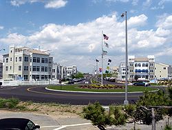
Country United States State New York County Queens Named for "R. Vernam", the signature of Remington Vernam Population (2000) - Total 15,893 Ethnicity - White 15.0% - Black 70.7% - Hispanic 16.5% - Asian 0.9% - Other 8.1% Economics - Median income $29,059 ZIP code 11692 Area code(s) 718, 347, 917 Arverne is a neighborhood in the New York City borough of Queens, on the Rockaway Peninsula. It was initially developed by Remington Vernam, whose signature "R. Vernam" inspired the name of the neighborhood.[1] Arverne extends from Beach 56th Street to Beach 73rd Street, along its main thoroughfare Beach Channel Drive, alternatively known as Rev. Joseph H. May Drive. The neighborhood is part of Queens Community Board 14.[2]
Contents
History
Vernam's original plan was to name the neighborhood Arverne-by-the-Sea, and one grandiose plan, influenced by his wife, Florence, included a canal running through the neighborhood, reminiscent of the Amstel canal in Amsterdam, Holland. When this plan fell through, the canal right-of-way was converted into a thoroughfare, Amstel Boulevard, which, except for a stub west of Beach 71st Street, was later incorporated into Beach Channel Drive.
While Arverne became well-known as a beachfront community with inexpensive summer bungalows, and hotels of varying levels of expense and luxury as well as amusements and boardwalk concessions, it also attracted a year-round residential community. On January 3, 1914, a violent storm devastated the neighborhood as well as other neighborhoods on the peninsula, and completely swept the Arverne Pier Theater, which was capable of seating 1,200 people, away to sea.[3] On June 15, 1922, a large part of Arverne was leveled by a disastrous fire which left about 10,000 people homeless, although the neighborhood was quick to rebuild.[4]
During the 1950s and 1960s, the advent of commercial jet air travel encouraged people to travel to distant destinations during the summer, rather than to utilize local beaches and resorts. As a result, many of Arverne's summer bungalows became vacant.[citation needed]
New York City's urban renewal projects of the 1960s leveled to the ground most of the summer resorts and some of the residences, many of which had been abandoned. The process eventually transformed most of Arverne, from Rockaway Beach Boulevard southward to the beachfront, into vacant land used as a dumping ground. Since the 1980s, but particularly since the Bloomberg administration, New York City has tried, albeit with only partial success, to improve the area, most notably via Arverne East Development's "Arverne-by-the-Sea".[5][6]
Education
Schools
The New York City Department of Education operates Arverne's public schools.
Libraries
The Queens Borough Public Library operates the Arverne Branch.
Housing
NYCHA
- Ocean Bay Houses (Oceanside), formerly Arverne Houses,
- Ocean Bay Houses (Bayside), formerly Edgemere Houses,
- Carleton Manor
Mitchell-Lama
- Nordeck Apartments (co-operative)
DHCR
- Ocean Village Apartments
References
- ^ Vandam, Jeff (February 13, 2005). "On the Beach, a Brand New Life". The New York Times. http://www.nytimes.com/2005/02/13/nyregion/thecity/13arve.html. Retrieved October 2, 2007. "His wife names the area Arverne because he signs his checks R. Vernam"
- ^ Queens Community Boards, New York City. Accessed September 3, 2007.
- ^ The Wave of Long Island, January 10, 1914, p. 1
- ^ "400 Buildings Burned at Arverne; 10,000 Made Homeless; 60 Injured, Loss $4,000,000 in Half Square Mile". The New York Times. June 16, 1922. http://query.nytimes.com/gst/abstract.html?res=9E06EEDD1231EF33A25755C1A9609C946395D6CF. Retrieved August 21, 2009.
- ^ http://www.muckety.com/Arverne-East-Development-LLC/5033362.muckety
- ^ http://www.arvernebythesea.com/
External links
Coordinates: 40°35′30″N 73°47′02″W / 40.591568°N 73.784008°W
Categories:- Neighborhoods in Queens
- Neighborhoods in Rockaway, Queens


Wikimedia Foundation. 2010.