- Ceyhan River
-

Ceyhan River (or historically Pyramos or Pyramus (Greek: Πύραμος) or the Leucosyrus[1] in Anatolia in south of Turkey or Asia Minor
Course of the river
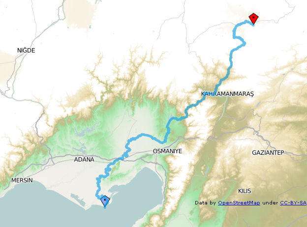
The Ceyhan River (Pyramus) has its source (known as Söğütlü Dere) at a location called Pınarbaşı 3 km on the Nurhak Mountains of the Eastern Taurus range, southeast of the town of Elbistan in the Kahramanmaraş province of Turkey . According to classical references its source is at Cataonia near the town of Arabissus.[2] Its main tributaries are called Harman, Göksun, Mağara Gözü, Fırnız, Tekir, Körsulu, Aksu (which joins Ceyhan at on the outskirts of Kahramanmaraş), Çakur, Susas, Çeperce. Its total length is 509 km or 316 miles.
In classical times for a time it passed under ground, but then came forward again as a navigable river, and forced its way through a glen of Mount Taurus, which in some parts was so narrow that Strabo claims a god can leap across it.[3] Its course, which to this point had been south, then turned to the southwest, and reached the sea. The river was deep and rapid [4]; its average breadth was 1 stadium[5].
At present, because of the narrow deep valleys that used exist, Ceyhan River has been dammed for hydroelectric generation, for flood control and for providing irrigation to fertile Cukurova region. The main hyroelectric generating dams are at Menzelet, Aslantaş, Sır and Berke. Of the deep valleys, only the one called Kisikli Canyon exists in its natural form at the south of the location the Menzelet Dam.
The quantity of water flow on the Ceyhan River changes greatly season by season. During August and September months the river is at its lowest flow. During November and December the autumn rains temporarily raise the water flow rate (from 50 cubic meters per second to 380 cubic meters per second). In January flow rate decreases until mid-February. As the snows melt in Taurus Mountains during Spring and early Summer months, the flow increases and, when it was not controlled by dams, there used be floods. During the last quarter of the 20th century, during the floods, the two rivers of the Cukurova plain, Ceyhan River and Seyhan River joined together at least 6 times.[6]
In classical times Ceyhan River reached the Mediterranean Sea at Mallus. Currently this location is inland a few miles from the Mediterranean coast on an elevation in the Karataş Peninsula, Adana Province, Turkey, a few miles from the town of Karataş. In classical times it carried with it such a quantity of mud, that, according to an ancient oracle, its deposits would one day reach the island of Cyprus, and thus unite it with the mainland.[7] The delta formed at the mouth of Ceyhan River is a refuge for wetlands birds and some years their numbers reach few millions. The sand bank in front is famed for nesting ground for sea turtles.
References
(Comp. Scylax, p. 40; Ptol. v.8.4; Plin. v.22; Mela, i.13; Curtius iii.7; Arrian, Anab. ii.5.8.)
Notes
- ^ Stephanus of Byzantium (s. v.) states that formerly this river had been called Leucosyrus.
- ^ Strabo i. p. 53, xiv. p. 675.
- ^ Strab. xii. p. 536.
- ^ Tzetzes. ad Lycophron 440.
- ^ Xenoph. Anab. i.4.1.
- ^ Source: [1] Turkcebilgi Encyclopedia website. (Turkish) (Reference date:29.6.2009)
- ^ Strab. l. c.; Eustath. ad Dionys., 867.
 This article incorporates text from a publication now in the public domain: Smith, William, ed (1854–57). "article name needed". Dictionary of Greek and Roman Geography. London: John Murray.
 Rivers of Turkey
Black Sea basin Marmara basin Aegean basin Mediterranean basin Aksu · Manavgat · Köprüçay · Göksu · Limonlu · Müftü (Efrenk) · Berdan · Seyhan · Ceyhan · Asi (Orontes)Persian Gulf basin Caspian basin Categories:- Cilicia
- Rivers of Turkey
Wikimedia Foundation. 2010.