- Berdan River
-
The Berdan River, also called the Tarsus River (Latin:Cydnus), is a river in Mersin Province, south Turkey. The historical city of Tarsus is by the river.
Contents
Geography
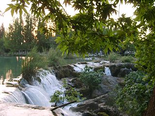
The main headwaters are in the Toros Mountains. There are two main tributaries: Kadıncık and Pamukluk (its upper reaches are called Cehennem Deresi). Total length of the river is 124 kilometres (77 mi) (including Kadıncık). Although the river is quite short, the average flow rate[1] is 42 m3/s, which is higher than most short rivers in the vicinity. The drainage basin is 1592 km2. It flows to the Mediterranean Sea at 36°28′N 34°30′E / 36.47°N 34.50°E. Just north of Tarsus there is a waterfall on the river, which is a popular picnic area for Tarsus residents.
Dams
Main article: List of dams in TurkeyThere are four dams on Berdan. These are used both for controlling floods and for producing electricity.[2] But the lower reaches of the river flow in an agricultural area, and because of the pollution caused by fertilisers the dams in the lower reaches are not used for drinking water.
Name of the dam Constraction date Installed power, MW [3] Kadıncık I 1971 70 Kadıncık II 1974 56 Berdan 1996 10 Pamuk 2003 23.9 Trivia
The Berdan River flows in one of the warmest regions of Turkey, but its upper reaches in the Toros Mountains make the water much cooler than the surrounding streams. History has two very well known accounts of heath problems caused by swimming in the river. In 333 BC Alexander the Great and in 833 AD Caliph Al-Ma'mun both swam in the river and both fell ill (pneumonia?); Al Mamun died of the illness.
References
- ^ A report by University of Mersin (in English)
- ^ A report by Chamber of Electrical Engineers, Mersin Branch (in Turkish)
- ^ 1 MW. = 106 W.
 Rivers of Turkey
Black Sea basin Marmara basin Aegean basin Mediterranean basin Aksu · Manavgat · Köprüçay · Göksu · Limonlu · Müftü (Efrenk) · Berdan · Seyhan · Ceyhan · Asi (Orontes)Persian Gulf basin Caspian basin Categories:- Rivers of Turkey
- Mersin Province
- Tarsus

Wikimedia Foundation. 2010.