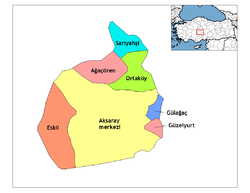
- Ortaköy, Aksaray
-
Ortaköy — District — Location of Ortaköy, Aksaray within Turkey. Coordinates: 38°44′N 34°02′E / 38.733°N 34.033°E Country  Turkey
Region Central Anatolia Province Aksaray Government – Governor Şenol Esmer – Mayor Mahmut Ütük (AKP) Area – District 725 km2 (279.9 sq mi) Elevation 1,140 m (3,740 ft) Population (2000)[1] – District 58,873 – Density 81.2/km2 (210.3/sq mi) – Urban 26,961 Time zone EET (UTC+2) – Summer (DST) EEST (UTC+3) Postal code 68xxx Area code(s) 0382 Licence plate 68 Website www.ortakoy.gov.tr Ortaköy is a town and district of Aksaray Province in the Central Anatolia region of Turkey, located north-west of the city of Aksaray, nearer to Kırşehir. According to 2000 census, population of the district is 58,873 of which 26,961 live in the town of Ortaköy.[1][2] The district covers an area of 725 km2 (280 sq mi),[3] and the average elevation is 1,140 m (3,740 ft).
This is a rural district centred around the small, quiet town of Ortaköy. The people in the area are conservative and there is little social life.
Contents
Places of interest
- Yunus Emre Türbesi - a tomb 25 km from the town, one of the many places in Turkey that claims to be the final resting place of the legendary folk-poet Yunus Emre.
Notes
- ^ a b Turkish Statistical Institute. "Census 2000, Key statistics for urban areas of Turkey" (in Turkish) (XLS). http://www.die.gov.tr/nufus_sayimi/2000tablo5.xls. Retrieved 2008-04-03.
- ^ GeoHive. "Statistical information on Turkey's administrative units" (in English). http://www.xist.org/cntry/turkey.aspx?levels=Ic%20Anadolu. Retrieved 2008-04-03.
- ^ Statoids. "Statistical information on districts of Turkey" (in English). http://www.statoids.com/ytr.html. Retrieved 2008-04-21.
References
- Falling Rain Genomics, Inc. "Geographical information on Ortaköy, Turkey" (in English). http://www.fallingrain.com/world/TU/0/Ortakoy6.html. Retrieved 2008-04-03.
- Turkish Ministry of Culture and Tourism. "General information on Ortaköy, Aksaray" (in Turkish). http://aksaray.turizm.gov.tr/BelgeGoster.aspx?F6E10F8892433CFFB0694A5E22DB3355CAC44E48D9FD67C0. Retrieved 2008-04-03.
External links
- District governor's official website (Turkish)
- District municipality's official website (Turkish)
- Aksaray governor's office (Turkish) / (English) / (French)
District governor's official website (Turkish) District governor's official website

District: OrtaköyTowns: Ortaköy • Balcı • Bozkır • Camuzluk • Çiftevi • Devedamı • Hacımahmutuşağı • Harmandalı • Hıdırlı • Ozancık • Sarıkaraman • Seksenuşağı Ortaköy, Aksaray in Aksaray Province (in the Central Anatolia region) of Turkey
Urban districts 
Rural districts RegionsAegean Black Sea Central Anatolia Eastern Anatolia Marmara Mediterranean Southeastern Anatolia Coordinates: 38°44′10″N 34°02′25″E / 38.73611°N 34.04028°E
Categories:- Districts of Aksaray
- Central Anatolia Region
- Aksaray
- Populated places in Aksaray Province
- Central Anatolia Region geography stubs
Wikimedia Foundation. 2010.


