- Oregon Route 27
-
For the unsigned Highway 27, see Alsea Highway. For the highway formerly known as the Crooked River Highway until about 1940, see Crooked River-Paulina Highway.
Oregon Route 27
Route information Maintained by ODOT Length: 44.78 mi (72.07 km) Existed: 1932 – present Major junctions South end:  US 20 near Brothers
North end:  US 26 in Prineville
Highway system Oregon highways
Routes • Highways← US 26US 30  →
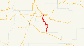
→Oregon Route 27 is an Oregon state highway, known as the Lower Crooked River Back Country Byway, or, more formally, the Crooked River Highway No. 14 (see Oregon highways and routes). It is located in Deschutes County and Crook County. OR 27 has the distinction of being one of the only state highways in Oregon which is partially unpaved; out of a 45-mile (72 km) total length, an 18½ mile stretch of the highway is gravel.
Contents
Route description
OR 27 has its southern terminus at a junction with U.S. Route 20 at Brothers, east of Bend. It runs north, along the Crooked River, towards Prineville Reservoir and the city of Prineville. It terminates in Prineville at a junction with U.S. Route 26.
The highway is commonly known as the Les Schwab Highway, as it serves a significant amount of freight traffic for the Les Schwab tire company, which is headquartered in Prineville. There have been numerous proposals over the years to pave the highway in its entirety; but no such projects have been undertaken due to lack of funding.
History
OR 27 used to extend further northwest to the town of Metolius, roughly following the present US 26.
Major intersections
- Note: mileposts do not reflect actual mileage due to realignments.
County Location Mile[1] Destinations Notes Deschutes 42.51 US 20 – Bend, BrothersCrook Prineville 0.00 US 26References
- ^ Oregon Department of Transportation, Public Road Inventory (primarily the Digital Video Log), accessed April 2008
External links
Categories:- State routes in Oregon
- Transportation in Deschutes County, Oregon
- Transportation in Crook County, Oregon


Wikimedia Foundation. 2010.