- Dannemora (town), New York
-
Dannemora, New York — Town — 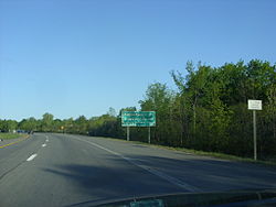 Location within the state of New York
 Dannemora, New York
Coordinates: 44°58′12″N 73°16′48″W / 44.97°N 73.28°WCoordinates: 44°58′12″N 73°16′48″W / 44.97°N 73.28°W Country United States State New York Counties Franklin, Essex Government – Type Town Council – Town Supervisor Americo Pivetta (D) – Town Council Members' ListArea – Total 65.8 sq mi (170.4 km2) – Land 59.2 sq mi (153.3 km2) – Water 6.6 sq mi (17.1 km2) Elevation 1,439 ft (439 m) Population (2010) – Total 4,898 Time zone Eastern (EST) (UTC-5) – Summer (DST) EDT (UTC-4) ZIP code 12929 Area code(s) 518 FIPS code GNIS feature ID Dannemora is a town in Clinton County, New York, United States. The population was 4,898 at the 2010 census. The name is reportedly from a locale in Sweden.
The Town of Dannemora contains a village also called Dannemora. Both village and town are on the west border of Clinton County, west of Plattsburgh.
Contents
History
The town was first settled around 1838.
A prison was opened in 1845 in order to use the prisoners in local mining operations. The town was formed in 1854 from the Town of Beekmantown.
Geography
According to the United States Census Bureau, the town has a total area of 65.8 square miles (170.4 km²), of which, 59.2 square miles (153.3 km²) of it is land and 6.6 square miles (17.1 km²) of it (10.06%) is water.
The west town line is the border of Franklin County.
Most of the town is within the Adirondack Park on the west side of the county. However, the statute defining the Adirondack Park specifically excludes Dannemora and nearby Altona, due to the prison facilities located in both towns.
New York State Route 374 is an east-west highway in Dannemora.
The Great Chazy River begins at the north end of Chazy Lake. Upper Chateaugay Lake empties through the Chateaugay Narrows into Lower Chateaugay Lake in Franklin County, which marks the beginning of the Chateaugay River.
Demographics
As of the census of 2000, there were 5,149 people, 850 households, and 584 families residing in the town. The population density was 87.0 people per square mile (33.6/km²). There were 1,253 housing units at an average density of 21.2 per square mile (8.2/km²). The racial makeup of the town was 56.30% White, 32.34% Black or African American, 0.54% Native American, 0.85% Asian, 0.04% Pacific Islander, 8.95% from other races, and 0.97% from two or more races. Hispanics or Latinos of any race were 15.87% of the population.[1]
There were 850 households out of which 30.8% had children under the age of 18 living with them, 52.2% were married couples living together, 11.6% had a female householder with no husband present, and 31.2% were non-families. 26.6% of all households were made up of individuals and 14.0% had someone living alone who was 65 years of age or older. The average household size was 2.46 and the average family size was 2.91.[1]
The age distribution was 10.3% under the age of 18, 11.7% from 18 to 24, 53.6% from 25 to 44, 18.0% from 45 to 64, and 6.4% who were 65 years of age or older. The median age was 35 years. For every 100 females there were 367.2 males. For every 100 females age 18 and over, there were 446.6 males.[1]
The median income for a household in the town was $37,805, and the median income for a family was $43,850. Males had a median income of $27,045 versus $25,132 for females. The per capita income for the town was $18,614. About 13.6% of families and 14.2% of the population were below the poverty line, including 24.3% of those under age 18 and 5.8% of those age 65 or over.[1]
Note: The census counts prisoners based on where they are incarcerated.[2] With the all-male state prison in Dannemora,[3] the data presented is likely to be skewed in comparison with the general town population and the population of neighboring non-prison towns, particularly with regard to ethnicity and the female:male ratio, because a disproportionate percentage of the prison population is male and black or Hispanic.[4]
Communities and locations in the Town of Dannemora
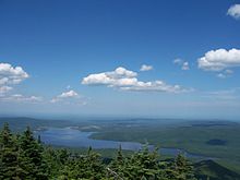 View of Chazy Lake from the top of Lyon Mountain
- Chateaugay Narrows – A short river that drains Upper Chateaugay Lake.
- Chazy Lake – A lake centrally located in the town.
- Chazy Lake – A hamlet on the west side of Chazy Lake.
- Clinton Correctional Facility – (also known as "Dannemora") One of New York State's maximum-security prisons is located in the Village of Dannemora (Lucky Luciano once served time there). The site also formerly housed the state's mental hospital for the criminally insane. Dannemora – The Village of Dannemora is on the south town line, located on NY-374.
- Dannemora Mountain – A small mountain north of the village.
- Ledger Corners – A location near the north town line on NY-374.
- Lyon Mountain – The hamlet of Lyon Mountain is in the western part of the town.
- Lyon Mountain Correctional Facility – A minimum security prison located in the western part of the town.
- Seine Bay – A small bay in Chazy Lake north of the community of Chazy Lake.
- Upper Chateaugay Lake – A lake partly in the northwest corner of the town.
See also
References
- ^ a b c d "American FactFinder". United States Census Bureau. http://factfinder.census.gov. Retrieved 2008-01-31.
- ^ "Counting prisoners". US Census Bureau. http://ask.census.gov/cgi-bin/askcensus.cfg/php/enduser/std_adp.php?p_faqid=1067&p_created=1141168018&p_sid=uZ34EH4k&p_accessibility=0&p_redirect=&p_srch=1&p_lva=&p_sp=cF9zcmNoPTEmcF9zb3J0X2J5PSZwX2dyaWRzb3J0PSZwX3Jvd19jbnQ9MTAsMTAmcF9wcm9kcz0mcF9jYXRzPSZwX3B2PSZwX2N2PSZwX3BhZ2U9MSZwX3NlYXJjaF90ZXh0PXByaXNvbg!!&p_li=&p_topview=1. Retrieved 2010-07-12.
- ^ "Facility Listing". NYS Department of Correctional Services. http://www.docs.state.ny.us/faclist.html. Retrieved 2010-07-12.
- ^ Richburg, Keith B. (2009-04-26). "Before Census, a Debate Over Prisoners". Washington Post. http://www.washingtonpost.com/wp-dyn/content/article/2009/04/25/AR2009042501403.html. Retrieved 2010-07-12. "You have a disproportionately black and Hispanic male population that is counted in the wrong spot."
External links
- Adirondack information
- Historical views of Dannemora
- Lyon Mountain Website
- Village of Dannemora Website
- Northern New York American-Canadian Genealogical Society
Municipalities and communities of Clinton County, New York City 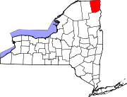
Towns Altona | Au Sable | Beekmantown | Black Brook | Champlain | Chazy | Clinton | Dannemora | Ellenburg | Mooers | Peru | Plattsburgh | Saranac | Schuyler Falls
Villages Champlain | Dannemora | Keeseville‡ | Rouses Point
CDPs Altona | Au Sable Forks | Churubusco | Cumberland Head | Lyon Mountain | Mooers | Morrisonville | Parc | Peru | Plattsburgh West | Redford
Footnotes ‡This populated place also has portions in an adjacent county or counties
Categories:- Towns in New York
- Populated places established in 1838
- Populated places in Clinton County, New York


Wikimedia Foundation. 2010.