- Maenporth
-
Coordinates: 50°7′28″N 5°5′36″W / 50.12444°N 5.09333°W
Maenporth is a cove and beach in west Cornwall, United Kingdom. It is situated approximately two miles (3 km) south-southwest of Falmouth on the estuary of the River Fal.[1]
Maenporth cove faces east across Falmouth Bay with views towards Pendennis Castle and the lighthouse on St Anthony Head.
The South West Coast Path runs through Maenporth. Behind the cove, wetland supports varied birdlife including the Grey Heron and the Little Egret.
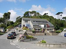
The beach shelves gently and at low water leaves an area of shallow water that is safe for swimming. The beach has facilities for launching boats, scuba diving and sea kayaking. Other facilities include car parking, a cafe and public toilets. On the hill above the beach there is modern holiday accommodation. Neighbouring beaches include Swanpool and Gyllyngvase.
History
There was once a chemical works here.[2] On the night of the 30 December 1978, the Scottish trawler Ben Asdale was wrecked off Maenporth.
References
- ^ Ordnance Survey: Landranger map sheet 204 Truro & Falmouth ISBN 9780319231494
- ^ Ward, C. S. & Baddeley, M. J. B. (1908) South Devon ... and South Cornwall .... (Thorough Guide Series; VII.) London: Thomas Nelson & Sons; pp. 176-77
Geography of Cornwall Cornwall Portal Unitary authorities Major settlements Bodmin • Bude • Callington • Camborne • Camelford • Falmouth • Fowey • Hayle • Helston • Launceston • Liskeard • Looe • Lostwithiel • Marazion • Newlyn • Newquay • Padstow • Par • Penryn • Penzance • Porthleven • Redruth • Saltash • St Austell • St Blazey • St Columb Major • St Ives • St Just-in-Penwith • St Mawes • Stratton • Torpoint • Truro • Wadebridge
See also: Civil parishes in CornwallRivers Topics History • Status debate • Flag • Culture • Places • People • The Duchy • Diocese • Politics • Hundreds/shires • Places of interest • full list...Categories:- Beaches of Cornwall
- Falmouth, Cornwall
- Populated coastal places in Cornwall
Wikimedia Foundation. 2010.


