- Mount Druitt, New South Wales
-
Mount Druitt
Sydney, New South Wales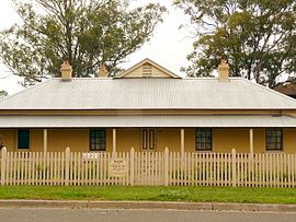
The Manse (mid-1880s)Population: 13,600 Postcode: 2770 Location: 43 km (27 mi) west of Sydney CBD LGA: City of Blacktown State District: Mount Druitt, Londonderry Federal Division: Chifley Suburbs around Mount Druitt: Dharruk Whalan Hebersham Plumpton North St Marys Mount Druitt Rooty Hill Oxley Park Colyton Minchinbury 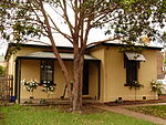 Former station master's cottage (circa 1867), Mt Druitt Road
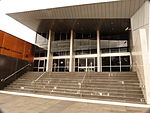 Mt Druitt Court House, North Parade
Mount Druitt is a suburb of Sydney, in the state of New South Wales, Australia. Mount Druitt is located 43 kilometres (27 mi) west of the Sydney central business district, in the local government area of the City of Blacktown, and is part of the Greater Western Sydney region.
There are numerous encompassing, smaller suburbs nearby including Bidwill, Blackett, Whalan, Tregear, Lethbridge Park and Emerton.
Contents
History
Major George Druitt (1775–1842) was granted 2,000 acres (8.1 km2) in the area by Governor Macquarie. He named his grant, where he died in 1842, Mount Druitt.[1]
Rail services to Mount Druitt commenced on 19 August 1881. The railway station operated as the post office between 1885 and 1918. The station had two platforms and a level crossing at the western end and included small goods yard, servicing a small mill. A railway gatekeeper's lodge was built circa 1867, and was later converted to the station master's cottage. It was later sold and converted to commercial use.
Electric train services to Mount Druitt commenced in 1955, at a service presided by then Premier of New South Wales, Joseph Cahill. In 1975, the railway station was relocated approximately 500 metres east to service a new shopping centre that was locally known as "The Great Western" and is now owned by Westfield. The old railway station was demolished almost immediately, although the level crossing remained until a road bridge carrying Carlisle Avenue over the railway line was completed. A footbridge was also built for pedestrians.
Mount Druitt Hospital was opened in 1982 by Queen Elizabeth II. The 200-bed hospital was opened following significant fundraising and political agitation from the local community due to perception that the community was unable to access medical services at either Blacktown or Nepean Hospitals.
In April 2006, the Attorney General's Department of New South Wales opened a new court house at a cost of A$12 million. This was to become the first metropolitan area courthouse to utilise 'Circle Sentencing', with aims to reduce over representation of Indigenous Australians in custody.[2][3]
A local landmark is the Georgian cottage known as The Manse, situated in The Avenue. It was probably built by John Harris in the mid-1880s; the land on which it was built was originally part of Druitt's property. Later it was sold to Robert Kennedy. Kennedy left it to the Presbyterian Church when he died, and it was used for some time as a manse. It was acquired by Blacktown City Council in 2000 and restored. It is now the headquarters of the Mt Druitt Historical Society and is open to the public. It has both a local government and state government heritage listing.[4]
Commercial area
The Mount Druitt township was serviced by a relatively small shopping area known as Mount Druitt Village. In 1975, a new shopping centre, known locally as "The Great Western", was opened approximately 500 metres to the east when the railway station was also relocated and a large bus/rail interchange was built. The Westfield corporation took over the shopping centre, which is now known as Westfield Mount Druitt, located on the corner of Carlisle Avenue and Luxford Road, both major roads in the area. The complex has over 200 stores, ranging from discount department stores to specialty shops. Shopsmart is another shopping centre located in the suburb. Other services such as a hospital, council-operated swimming pool and library are all located within walking distance of the railway station.
Transport
Mount Druitt railway station is located on the Western Line of the CityRail network. It features a newly upgraded interchange with bus routes operated by the private Busways with routes to all suburbs in the Mount Druitt area, Blacktown and Glendenning.
Mount Druitt is close by to the M4 Western Motorway and Westlink M7 Motorway, providing ready access to all areas of Sydney. The 2001 City of Blacktown Social Plan noted that Mount Druitt residents are significantly more likely than the average Blacktown resident to not have access to a private car.
Education
Mount Druitt High school was established in the 1960s.[5] Interestingly, this school is now actually located within the suburb of Dharruk, adjacent to the local Emerton Shopping Village. It later became known as Chifley College Mount Druitt Campus, educating Years 7-10. Chifley College Senior Campus educates the senior classes (Years 11-12), and is within walking distance from Mount Druitt Station.
In 1996, Year 12 students at Mount Druitt High School were deemed by the Daily Telegraph to have failed the HSC. Subsequent to this story being published, The Australian Press Council upheld a number of complaints regarding the article,[6] based on there not being a system of awarding pass and fail marks for students undertaking the HSC, and a class action for defamation was won against the publishers.[7] As a result of this court case the publishers issued a retraction and apology.[8]
Population
Demographics
The 2001 City of Blacktown Social Plan identified that a high portion of Mount Druitt residents are migrants from non-English speaking nations, and that they tend to work in Blue collar jobs.[9] These statements are backed up by the 2006 census conducted by the Australian Bureau of Statistics. It states that 46% of Mount Druitt's 13,583 residents were born overseas, more than double the national average, with 10.6% born in the Philippines, 3.3% from Iraq and 3.2% from Fiji. The most common occupation categories were clerical (18%), labourers (16%), machinery operators (15%) and tradespeople (14%). The suburb had a higher than average number of rental properties (38%) although a smaller than average number of these were state housing (5%).[10]
See also
- Mount Druitt Hospital
- Mount Druitt Waterworks
- The Lives of Mount Druitt Youth
References
- ^ "Mount Druitt". Geographical Names Board of New South Wales. http://www.gnb.nsw.gov.au/name_search/extract?id=anwGXtWAan. Retrieved 2007-01-05.
- ^ "Mount Druitt Court opens". Attorney General's Department of New South Wales. 2006-04-26. http://www.lawlink.nsw.gov.au/Lawlink/Corporate/ll_corporate.nsf/pages/LL_Homepage_announcements. Retrieved 2006-12-29.
- ^ Erin O'Dwyer (2005-10-16). "Court circle of shame helps beat black crime". The Sun-Herald. http://www.smh.com.au/news/national/court-circle-of-shame-helps-beat-black-crime/2005/10/15/1128796748221.html#. Retrieved 2006-12-31.
- ^ State Heritage Website
- ^ Chifley College - Mount Druitt Campus - Celebrating 40 Years of Education
- ^ "Australian pres Council - Adjudication No.910". AustLII. http://beta.austlii.edu.au/au/other/apc/1997/11.html. Retrieved 2009-04-12.
- ^ Lesley Branagan (2005-10-02). "Class Act - No Longer Failures" (readio transcript (html)). ABC Radio National. http://www.abc.net.au/rn/talks/bbing/stories/s1470367.htm. Retrieved 2006-12-04.
- ^ "Telegraph apologises to Mount Druitt students". NSW Teachers Federation. http://www.nswtf.org.au/edu_online/13/gdruitt.html. Retrieved 2009-04-12.
- ^ WESTIR Ltd (2003). "The 2001 City of Blacktown Social Plan" (PDF). City of Blacktown. http://www.blacktown.nsw.gov.au/our-city/statistics/suburb-profiles.cfm. Retrieved 2006-08-26.
- ^ Australian Bureau of Statistics (25 October 2007). "Mount Druitt (State Suburb)". 2006 Census QuickStats. http://www.censusdata.abs.gov.au/ABSNavigation/prenav/LocationSearch?collection=Census&period=2006&areacode=SSC11687&producttype=QuickStats&breadcrumb=PL&action=401. Retrieved 2009-04-12.
Coordinates: 33°46′20″S 150°49′10″E / 33.7722°S 150.8194°E
Suburbs of the City of Blacktown · Western Sydney Acacia Gardens · Arndell Park · Bidwill · Blackett · Blacktown · Colebee · Dean Park · Dharruk · Doonside · Eastern Creek · Emerton · Glendenning · Glenwood · Hassall Grove · Hebersham · Huntingwood · Kellyville Ridge · Kings Langley · Kings Park · Lalor Park · Lethbridge Park · Marayong · Marsden Park · Minchinbury · Mount Druitt · Oakhurst · Newbury · Parklea · Plumpton · Prospect · Quakers Hill · Riverstone · Rooty Hill · Ropes Crossing · Rouse Hill · Schofields · Seven Hills · Shalvey · Shanes Park · Stanhope Gardens · Toongabbie · The Ponds · Tregear · Vineyard · Whalan · Willmot · WoodcroftCategories:- Suburbs of Sydney


Wikimedia Foundation. 2010.