- Marayong, New South Wales
-
Marayong
Sydney, New South Wales
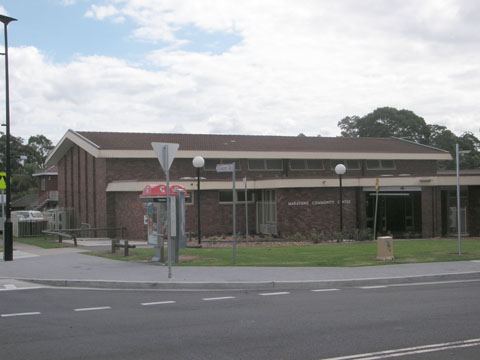
Marayong Community CentrePopulation: 6800 (2006) Established: 1926 Postcode: 2148 Location: 38 km (24 mi) west of Sydney CBD LGA: City of Blacktown State District: Blacktown Federal Division: Chifley Suburbs around Marayong: Quakers Hill Quakers Hill Acacia Gardens Quakers Hill Marayong Kings Park Doonside Woodcroft Blacktown Marayong is a suburb of Sydney, in the state of New South Wales, Australia. Marayong is located 38 kilometres west of the Sydney central business district, in the local government area of the City of Blacktown and is part of the Greater Western Sydney region.
Contents
History
Marayong is derived from an Aboriginal word 'Marriang' meaning emu or place of cranes. The name was first given by the New South Wales Railways to the railway station when it opened in October 1922. [1][2]
Around 1900–1905, large areas were subdivided and market gardens and poultry farms were established. The area was part of Quakers Hill but in 1926 the Marayong Progress Association applied to have Marayong made a suburb, in its own right.
The area was mostly rural until the 1960s. Housing Commission (public housing) estates, opened in the 1960s, marked the urbanisation of the suburb predominantly south of the railway line. In addition, an industrial area was also released north of the railway line.
Population
The population of Marayong was 6821 at the 2006 census. The median household income of $993 per week was a bit less than the national average and there were a higher than average number of clerical and administrative workers (18.4%) and technicians and tradesworkers (16.4%). There were a substantial number of people born in the Philippines (6.5%) and the number of Catholics in Marayong (40.6%) was well above the national average.[3]
Transport
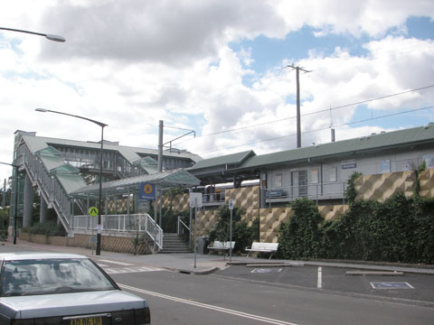
 Marayong railway station
Marayong railway station is on the Richmond branch of the Western Line of the CityRail network. It provides services out to Richmond and in to the city via Blacktown and Parramatta.
Richmond Road marks the southern boundary of the suburb and provides links to Blacktown and Richmond while the Westlink M7 curls around the suburb and can be accessed via the Sunnyholt Road intersection at Kings Park or the Richmond Road intersection at Dean Park.
Schools
There are two government-run primary schools in the suburb, Marayong Public and Marayong Heights Public. There is also a Catholic primary school, St Andrews Primary and a high school St Andrews College which is divided into two campuses, the Holy Family campus on Quakers Road catering to years 7-10 and the John Paul II senior campus on Breakfast Road. The nearest government-run high schools are Quakers Hill High School, Blacktown Boys, Blacktown Girls and Doonside Technology High.
References
- ^ The Book of Sydney Suburbs, Compiled by Frances Pollen, Angus & Robertson Publishers, 1990, Published in Australia ISBN 0-207-14495-8
- ^ "Marayong". Blacktown City Council. http://www.blacktown.nsw.gov.au/blacktown/index.cfm?24791DA8-BCD9-D616-BA12-41A5D8FC6EBD. Retrieved 2009-04-25.
- ^ Australian Bureau of Statistics (25 October 2007). "Marayong (State Suburb)". 2006 Census QuickStats. http://www.censusdata.abs.gov.au/ABSNavigation/prenav/LocationSearch?collection=Census&period=2006&areacode=SSC11627&producttype=QuickStats&breadcrumb=PL&action=401. Retrieved 2009-04-25.
Coordinates: 33°45′00″S 150°54′30″E / 33.7500°S 150.9083°E
Suburbs of the City of Blacktown · Western Sydney Acacia Gardens · Arndell Park · Bidwill · Blackett · Blacktown · Colebee · Dean Park · Dharruk · Doonside · Eastern Creek · Emerton · Glendenning · Glenwood · Hassall Grove · Hebersham · Huntingwood · Kellyville Ridge · Kings Langley · Kings Park · Lalor Park · Lethbridge Park · Marayong · Marsden Park · Minchinbury · Mount Druitt · Oakhurst · Newbury · Parklea · Plumpton · Prospect · Quakers Hill · Riverstone · Rooty Hill · Ropes Crossing · Rouse Hill · Schofields · Seven Hills · Shalvey · Shanes Park · Stanhope Gardens · Toongabbie · The Ponds · Tregear · Vineyard · Whalan · Willmot · WoodcroftList of Sydney suburbs Categories:- Suburbs of Sydney
- Australian Aboriginal placenames
- Sydney geography stubs
Wikimedia Foundation. 2010.