Marayong railway station

Marayong railway station
Cityrailsign.svg
Marayong
Western Line
Station code MYG
Suburb Marayong
Street(s) Railway Road
Distance from Central Station 37.41 km
Altitude (above sea level)  ? m
Types of stopping trains Suburban all stations
Suburban limited stops
Number of platforms 2
Number of tracks 2
Platform arrangement 1 Island
Type of station Ground
Ticket barriers No
Transfers available Bus
Disabled access Handicapped/disabled access 
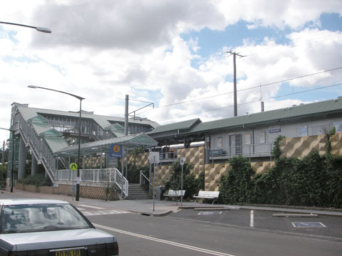
Yes
Station facilities Link

Marayong is a station on the Richmond branch of the CityRail Western line. Marayong is an Easy Access station, which means that wheel chairs can enter the platforms.

Contents

Platforms and services

NightRide service N71 operates on Friday, Saturday and Sunday mornings between Richmond and Town Hall

The station is served by two trains per hour each way, with additional trains during weekday peak hours.

Platform Line Stopping Pattern Notes
CR Plat 1.png
Western Line all stations and limited stops services to Blacktown and Central; then on to the North Shore Line. one weekday (Cumberland Line) afternoon peak services starts from Quakers Hill
CR Plat 2.png
Western Line all stations services to Quakers Hill, Riverstone and Richmond. one weekday (Cumberland Line) morning peak services continues west to Quakers Hill

Trackplan

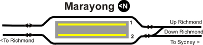
Track arrangement at Marayong

See also

Neighbouring stations

Preceding station   CityRail   Following station
Quakers Hill
towards Richmond
Western Line
Richmond Branch
Blacktown
towards Central

Coordinates: 33°44′46″S 150°54′01″E / 33.74610°S 150.90016°E / -33.74610; 150.90016


Wikimedia Foundation. 2010.

Игры ⚽ Поможем решить контрольную работу

Look at other dictionaries:

  • Marayong railway station, Sydney — Cityrail Station alt|station name=Marayong servicearea=Western Line|servicearea color=#Western line colour|servicearea textcolor=black code=MYG|suburb=Marayong|street=Railway Pde|distance=37.41|altitude=?|traintype=Suburban all stations Suburban… …   Wikipedia

  • Doonside railway station — Doonside …   Wikipedia

  • Marayong, New South Wales — Marayong Sydney, New South Wales Marayong Community Centre Populatio …   Wikipedia

  • Mount Druitt railway station — Mount Druitt …   Wikipedia

  • Quakers Hill railway station, Sydney — Cityrail Station alt|station name=Quakers Hill servicearea=Western Line|servicearea color=#Western line colour|servicearea textcolor=black code=QKH|suburb=Quakers Hill|street=Railway Pde|distance=40.09|altitude=?|traintype=Suburban all… …   Wikipedia

  • Richmond railway line, Sydney — Public transport infrastructure in Sydney logo= name=Richmond Line transport mode=Commuter rail line line owner=CityRail operation area=Western Sydney map colour=Yellow stations number=10 interchange names=Blacktown operator names=CityRail fleet… …   Wikipedia

  • Cumberland railway line, Sydney — Public transport infrastructure in Sydney logo= name=Cumberland Line transport mode=Commuter rail line owner=CityRail operation area= map colour=Magenta line length=47 km stations number=23 interchange names=Campbelltown Blacktown operator… …   Wikipedia

  • City of Blacktown — This article is about the local government area. For the electoral district, see Electoral district of Blacktown. For the suburb, see Blacktown, New South Wales. City of Blacktown New South Wales …   Wikipedia

  • Blacktown — City of Blacktown Lage der Blacktown City in Sydney Basisdaten Bundesstaat: New South Wales Hauptort: Blacktown Fläche: 2 …   Deutsch Wikipedia

  • Blacktown, New South Wales — Infobox Australian Place | type = suburb name = Blacktown city = Sydney state = nsw caption = St. Paraskevi Greek Orthodox Church, Blacktown lga = City of Blacktown postcode = 2148 est = pop = 39,000 area = propval = stategov = Blacktown fedgov …   Wikipedia

Share the article and excerpts

Direct link
Do a right-click on the link above
and select “Copy Link”