- Ochoco Mountains
-
Ochoco Mountains Range 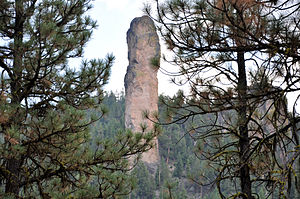 Steins Pillar
Country United States State Oregon Part of Blue Mountains province Highest point Lookout Mountain (Oregon) - elevation 6,926 ft (2,111 m) - coordinates 44°19′37″N 120°22′23″W / 44.326976°N 120.372987°W Length 114 mi (183 km), North-South Width 86 mi (138 km) Area 4,889 km2 (1,888 sq mi) Geology Uplifted accreation, and volcanic Period Permian, Triassic, Jurassic, and Eocene The Ochoco Mountains are a mountain range in central Oregon. The Ochoco Mountains form the western end of the Blue Mountains province. The mountains were formed when Permian, Triassic, and Jurassic rocks were slowly uplifted by volcanic eruptions to form the Clarno Formation. Today, the highest point in the range is Lookout Mountain. The dominant vegetation on the west side of the range is old growth Ponderosa pine; on the east side Western juniper is common. The western area of the Ochoco Mountains is administered by the Ochoco National Forest. The southeastern part of the range is part of the Malheur National Forest. The Ochoco Mountains are an excellent area for hiking, camping, bird watching, rockhounding, and hunting as well as cross-country skiing in the winter.
Contents
Geology
The Ochoco Mountains in central Oregon form the western end of the Blue Mountains province. The Blue Mountains are not a single cohesive range, they are a complex of mountain ranges and inter-mountain basins and valleys which extend from the northeast corner of Oregon southwestward into central Oregon ending near Prineville. The Ochoco portion of the province is part of a wide uplifted plateau, made of rocks from the Permian, Triassic, and Jurassic periods (300 to 200 million years old) which were transported by the Pacific Plate and accreated in the late Mesozoic era (about a 100 million years ago) as part of a vast shallow sea, and then slowly uplift by volcanic eruptions during the Eocene epoch (50 to 37 million years ago) to form the Clarno Formation. From 37 to 17 million years ago, eruptions in the western Cascades spread ash across eastern Oregon, forming the John Day Formation. From 17 to 14 million years ago, major volcanic eruptions covered much of the province with the basalt flows that comprise the Columbia River Basalt Group. Since then, continued faulting and uplift has resulted in a deeply eroded landscape. Stein’s Pillar is an excellent example of this erosion.[1]
During the Eocene epoch, central Oregon volcanoes deposited layers of lava and ash up to 1,000 feet (300 m) thick over the area that is now the Ochoco Mountains. Large mudflows called lahars were also common during that period. These mudflows often covered and preserved the plants and animals, resulting in fossil beds. Today, fossils of prehistoric trees, fruits, nuts, and flowers can be found in the Ochoco Mountains along with fossilized animals including horses, camels, rhinoceros, and hippopotamus.[2]
Topography
The Ochoco Mountain covers an area of 4,889-square-mile (12,660 km2), running 114 miles (183 km) north to south and 86 miles (138 km) east to west.[3] The eight highest peaks in the range are:
- Lookout Mountain, summit 6,926 feet (2,111 m)
- Spanish Peak, summit 6,871 feet (2,094 m)
- Mount Pisgah, summit 6,816 feet (2,078 m)
- Round Mountain, summit 6,755 feet (2,059 m)
- East Point, summit 6,625 feet (2,019 m)
- North Point, summit 6,607 feet (2,014 m)
- Wolf Mountain, summit 6,483 feet (1,976 m)
- View Point, summit 6,266 feet (1,910 m)[3]
Ecology
The vegetation in the Ochoco Mountains ranges from old growth Ponderosa pines on the western slopes and in the mountain valleys to western juniper and sagebrush on the eastern and southern slopes. The high mountain meadows host a wide variety of wild flowers and even ferns in some areas. Big Summit Prairie near the center of the Ochoco Range is well known for its spring wild flowers displays.[4]
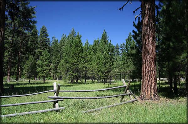
 Ponderosa pine forest land in the Deep Springs area
Ponderosa pine is the dominant tree species in most parts of the Ochoco Mountains. These pines are common at elevations from 3,000 to 6,100 feet (1,900 m) above sea level. Manzanita, antelope bitterbrush, and ceanothus are common shrubs in the pine-dominated areas with Idaho fescue and Ross' sedge as the main ground cover. Ponderosa pine forests are tolerant of drought and are adapted to survive low-intensity wildfires. Birds commonly found in the pine forests of the Ochoco Mountains include the northern flicker, hairy woodpecker, red-tailed hawk, and Steller's jay. Central Oregon’s ponderosa pine forests are an important winter range for mule deer and Rocky Mountain elk.[5]
On the dryer eastern side of the Ochoco Mountains, the Western juniper trees survive on as little as eight inches (203 mm) of precipitation per year. The Ochoco’s juniper woodland cover wide areas from 3,000 to 4,300 feet (1,300 m) in elevation. Antelope bitterbrush and sagebrush are common shrubs in these areas with Idaho fescue and bluebunch wheatgrass as the main ground cover. Juniper woodlands are home to mountain bluebirds, Townsend's Solitaires, and ferruginous hawks during the spring and summer. There are also many small mammals and lizards that are prey for coyote.[5]
 Camas flower in Big Summit Prairie
Big Summit Prairie is a large high country meadow in the middle of the Ochoco Mountains. Big Summit meadow covers twenty square miles. The prairie is covered by water-loving grasses, overgrown by willows and shrubs in some areas. Tufted hairgrass, elephant's head, and horsetail are common ground cover in the vast meadow land. Quaking aspen with shrubby undergrowth attract wildlife not found in other parts of the Ochoco Mountains. Common birds include sandhill crane, Wilson's Snipe, long-billed curlew, and northern harrier. Even the rare dickcissel has been sighted at Big Summit Prairie. Larger animals include mule deer, pronghorn antelope, Belding's ground squirrel, Northern Pocket Gopher, meadow mice, and coyotes. Also, Rocky Mountain elk move into the area in the fall.[6][7]
Big Summit Prairie is particularly well known from its wildflowers and butterflies. From April through June, flowers cover Big Summit meadow. The first wildflowers to bloom are usually grass widow, wild parsley, and shooting stars. From May through June, Wyethia, buttercups, and camas display their colors. In drier areas, bitterroot bloom with large white and pink flowers. In June and July, other flowers take over the display including Missouri iris, larkspur, Indian paintbrush, checkermallow, and arrowleaf balsamroot. One notable plant is Peck’s Mariposa Lily, a type of Calochortus with lavender petals. This plant is found only in the Ochoco Mountains. Butterfly species common to the Big Summit Prairie include hairstreak, skipper, Eastern tailed-blue, Lycaenidae, checkerspot, fritillary, swallowtail, admiral, and tortoiseshell.[6][7]
Human uses
Most of the Ochoco Mountains are public lands, administered by the United States Forest Service. The Ochoco National Forest is responsible for most of the mountain area; however the southeastern part of the range in the Malheur National Forest. Some land in the Ochoco area is also administered by the Bureau of Land Management. Hiking, fishing, camping, hunting, horseback riding, bird watching, and rockhounding are all popular activities.[8]
The Ochoco National Forest maintains 27 campgrounds in or near the Ochoco Mountains. The largest are Antelope Flat Reservoir, Ochoco Divide, Walton Lake, and Wildcat campground.[9] The Malheur National Forest has several campgrounds in the Ochoco Mountains as well. The largest is the campground at Delintment Lake.[10]
- Antelope Flat Reservoir campground has 24 camp sites surrounded by a scenic Ponderosa pine forest. The reservoir is not visible from the campground, but it is only a 10 minute walk to the lake shore. The campground is at 4,600 feet (1,400 m) elevation. Potable water is available at the site along with picnic tables, fire pits, and vault toilets. The area is lightly used except on holiday weekends. Fishing, swimming, boating, and hiking are favorite activities.[11]
- Ochoco Divide Campground is located in an old growth Ponderosa pine forest just off scenic U.S. Highway 26, 30 miles (48 km) east of Prineville, Oregon. The campground is located at 4,600 feet (1,400 m) elevation. It has 28 camp sites, picnic tables, fire pits, and vault toilets. The campground is commonly used as an overnight stop for highway travelers, who then move on in the morning. As a result, the campground is often full at night, but very quiet during the day. Bandit Springs highway rest stop is one mile (1.6 km) west of the campground. The rest stop is the trailhead for several hiking trails. These trails are popular for hiking and mountain biking in the summer and cross-country skiing in the winter.[12]
-
Walton Lake is a small lake surrounded by old growth Ponderosa pine and mountain meadows. The lake is stocked with Rainbow trout each summer. Two hiking trails are located in the area. The Walton Lake Trail is a one mile (1.6 km) loop around the lake while Round Mountain National Scenic Trail is a 7.5-mile (12.1 km) hike that offers the opportunity to see high country wildlife and many varieties of birds. The campground is located at 5,000 feet (1,500 m) elevation. The site has potable water, picnic tables, fire pits, level tent sites, and vault toilets. There is also a day-use picnic area with two tables, cooking grills, a sandy lake shore beach, and a fishing pier. Fishing, swimming, boating, and hiking are popular activities at Walton Lake.[13]
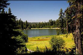 Walton Lake and meadow in the Ochoco Mountains
- Wildcat Campground is located southwest corner of Mill Creek Wilderness, approximately 19 miles (31 km) from Prineville. The campground is located at 3,700 feet (1,100 m) elevation. It has 17 camp sites, potable water, picnic tables, fire pits, and vault toilets. A trailhead leading into the Mill Creek Wilderness is located adjacent to the campground. It connects to a network of hiking trails in the Mill Creek and Twin Pillars areas.[14]
- Delintment Lake Campground is located 45 miles (72 km) northwest of Burns, Oregon. The campground is located at an elevation of 5,600 feet (1,700 m). It has 33 camp sites, potable water from a hand-pump, 12 picnic sites, and vault toilets. Hiking, fishing, swimming, boating, and wildlife viewing are popular activities at Delintment Lake.[15]
 Thundereggs like these are found at Whistle Springs
The unique geology of the Ochoco Mountains has resulted in a wide variety of rock types being located in a relatively small area. This brings rockhounds to the area every summer. The Bureau of Land Management and the Ochoco National Forest both have designated areas where rockhounds can search for agate, jasper, petrified wood, petrified moss, and dendrite. These rock collection sites are for personal use only, gathering rocks for commercial purposes is prohibited. Thundereggs can be found at Whistle Springs. Even though the area has been worked by rockhounds for many years, quality thunder eggs are still found at the site. There are also some rare rocks and minerals found in the central Oregon in or near the Ochoco Mountains including opals, amethyst, gem quality calcite, cinnabar, selenite, gypsum, and amygdaloid nodules.[16][17]
Wilderness areas
The Ochoco National Forest has three wilderness areas in the Ochoco Mountains. They are Bridge Creek Wilderness, Black Canyon Wilderness, and Mill Creek Wilderness.
- Bridge Creek Wilderness is very remote; and at 5,400 acres (22 km2), it is the smallest wilderness in Oregon. It has few visitors except during the fall hunting season. Its topography is dominated by steep forested slopes and barren plateaus, although it has some mountain meadow lands as well. The wilderness contains important winter elk habitat along Bridge Creek. Other large mammals common to the area include includes mule deer, black bear, and cougar. Pileated Woodpecker, goshawks, and prairie falcons nest in the Bridge Creek area. There are no trails in the Bridge Creek Wilderness, so this area is for experienced outdoorsmen.[18]
- Black Canyon Wilderness encompasses 13,400 acres (54 km2) with elevations ranging from 3,900 to 6,400 feet (2,000 m) above sea level. The Black Canyon environment ranges from dense forest to steep basalt cliffs. The Black Canyon Wilderness is home to a wide range of wildlife including deer, elk, black bear, and cougar. Wildflowers such as crimson columbine, lupine, and Indian paintbrush can be found throughout the wilderness. There are several hiking trails, all very rugged.[19]
- Mill Creek Wilderness includes 17,000 acres (69 km2) of protected land. The wilderness characterized by deep canyons and towering pinnacles including a pair of volcanic plugs called the Twin Pillars. These two rock outcroppings are found along the Twin Pillars Trail National Recreational Trail. The trailhead is at Wildcat Campground, just outside the wilderness boundary. Mill Creek Wilderness has a 21-mile (34 km) network of trails. The trails are used by both hikers and horse riders; however, the entire trail system is extremely rugged with many steep climbs and descents. The wilderness is dense pine and fir forest dissected by Mill Creek and its tributaries. Elk and deer are common in the Mill Creek area as well as black bear, wild turkey, pileated woodpeckers, and goshawks. In the fall, the Mill Creek Wilderness is a popular area for hunters.[20]
References
- ^ "Blue Mountain Province", Deschutes and Ochoco National Forests, United States Forest Service, United States Department of Agriculture, Bend, Oregon, 10 March 2005.
- ^ "Additional Points of Interest - Geology of Central Oregon", Prineville Crook County Chamber of Commerce, Prineville, Oregon, 2 April 2009.
- ^ a b "Ochoco Mountains", Peakbagger.com Database, Geographic Research Systems, Peakbagger.com, Seattle, Washington, 2 April 2009.
- ^ Walton, Aaron, "Ochoco Mountains – Central Oregon", Wonder the West, www.wanderthewest.com, Bend, Oregon, 2 April 2009.
- ^ a b "Habitats", Deschutes and Ochoco National Forests, United States Forest Service, United States Department of Agriculture, Prineville, Oregon, 11 March 2004.
- ^ a b "Big Summit Prairie", Deschutes and Ochoco National Forests, United States Forest Service, United States Department of Agriculture, Prineville, Oregon, 29 March 2004.
- ^ a b "Big Summit Prairie", Rangeland Management Botany Program, United States Forest Service, United States Department of Agriculture, Washington, D.C., 24 June 2008.
- ^ "General Info", Deschutes and Ochoco National Forests, United States Forest Service, United States Department of Agriculture, Prineville, Oregon, 29 August 2006.
- ^ "Lookout Mountain Ranger District", Deschutes and Ochoco National Forests, United States Forest Service, United States Department of Agriculture, Prineville, Oregon, 28 May 2008.
- ^ "Developed Campgrounds", Malheur National Forests, United States Forest Service, United States Department of Agriculture, John Day, Oregon, 19 June 2007.
- ^ "Antelope Flat Reservoir", Deschutes and Ochoco National Forests, United States Forest Service, United States Department of Agriculture, Prineville, Oregon, 22 July 2004.
- ^ "Ochoco Divide Campground", Deschutes and Ochoco National Forests, United States Forest Service, United States Department of Agriculture, Prineville, Oregon, 5 August 2008.
- ^ "Walton Lake Campground and Trailhead", Deschutes and Ochoco National Forests, United States Forest Service, United States Department of Agriculture, Prineville, Oregon, 24 June 2008.
- ^ "Wildcat Campground", Deschutes and Ochoco National Forests, United States Forest Service, United States Department of Agriculture, Prineville, Oregon, 17 May 2005.
- ^ "Delintment Lake Campground", Malheur National Forests, United States Forest Service, United States Department of Agriculture, John Day, Oregon, 19 June 2007.
- ^ "Rockhounding", Deschutes and Ochoco National Forests, United States Forest Service, United States Department of Agriculture, Prineville, Oregon, 7 February 2006.
- ^ "Whistle Springs", Deschutes and Ochoco National Forests, United States Forest Service, United States Department of Agriculture, Prineville, Oregon, 23 February 2005.
- ^ "Bridge Creek Wilderness", Deschutes and Ochoco National Forests, United States Forest Service, United States Department of Agriculture, Prineville, Oregon, 16 August 2004.
- ^ "Black Canyon Wilderness", Deschutes and Ochoco National Forests, United States Forest Service, United States Department of Agriculture, Prineville, Oregon, 16 August 2004.
- ^ "Mill Creek Wilderness", Deschutes and Ochoco National Forests, United States Forest Service, United States Department of Agriculture, Prineville, Oregon, 16 August 2004.
External links
Categories:- Mountain ranges of Oregon
- Regions of Oregon
- Landforms of Crook County, Oregon
- Landforms of Harney County, Oregon
- Volcanism of Oregon
- Permian volcanism
- Triassic volcanism
- Jurassic volcanism


Wikimedia Foundation. 2010.