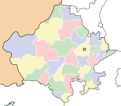
- Nangal Abhaypura
-
Nangal
नाँगल
Nangal — village — Coordinates 27°37′N 75°09′E / 27.62°N 75.15°ECoordinates: 27°37′N 75°09′E / 27.62°N 75.15°E Country India State Rajasthan District(s) Sikar Sarpanch Prahalad Rai Population
• Density
3,000
• 10 /km2 (26 /sq mi)
Literacy 92.98%% Official languages [[Hindi],[Marwari]] Time zone IST (UTC+05:30) Area
2 square kilometres (0.77 sq mi)
• 427 metres (1,401 ft)
Climate
Temperature
• Summer
• Winter
• 48 °C (118 °F)
• 1 °C (34 °F)Distance(s)-
• From Palsana • 9 kilometres (5.6 mi) (land) • From Khendla • 11 kilometres (6.8 mi) (land)
Footnotes- 1
Nangal (Hindi: नाँगल) is a village located in the Palsana district Sikar region of Rajasthan state in India. It is a big village of Gram Panchayat Abhaypura. It is 11 km away from Palsana, 10 km from Khandela 3 km from Bamanwas and 3.5 km from Dudhwalo ka Bass.
Contents
Geography
Nangal is located at 27°37′N 75°09′E / 27.62°N 75.15°E.[1] It has an average elevation of 427 metres (1400 feet).
Demographics
Nangal village has a population of about 3,000 people. However, because it covers a big area and many towns, population of the village was 2,287 according to census in 2001. The population density of the village was 29 according to the same census. Males constitute 52% of the population. Nangal has an average literacy rate of 92.98% as per the 2011 census, higher than the state average of 67.05%: male literacy is 86.66%, and female literacy is 58.76%. In Sikar, 16% of the population is under 6 years of age.
The main caste groups are Kharra, Mawliya,[2] kumawats, Jats, Gujjars/Meenas, and functionary caste as Khati, Lohar, Sunar and Nai are also found in Nangal and nearest villages like Abhaypura.[3][4]
History of Kharra
Nangal was the biggest village of the Gram Panchyat Abhaypura. We find connection of Kharras with the history of Burdak clan. Thus Mom Raj Dhaka of village Ganora was mansabdar of Delhi Badshah Nasirudin Mahmood. He could not defeat Burdaks of Sarnau in six direct wars. He started conspiracy how to defeat Burdaks. He got the secret information about Burdaks that they all gather and take bath unarmed at Halani Baori at Sarnau on the amavashya tithi of Ashwin month for performing the annual shradha of their ancestors. On such occasion on amavashya tithi of Ashwin month of samvat 1315 (1258 AD) when all Burdaks gathered to take bath unarmed at Halani Baori at Sarnau, Mom Raj Dhaka attacked them with an army of 25000. All Burdaks were killed. The village and Fort of Sarnau was reduced to ashes. It so happened that Rambha of gotra Kharra, the wife of Kunwar Padam Singh Burdak, was not in the Sarnau fort at that time. She was away with his in-laws at village ‘Kharra-Ka-Gothra’ and hence was saved. She had a pregnancy of three months at that time. She gave birth to a child in nanihal village ‘Kharra-Ka-Gothra’ at ‘Dungar ki Ghati’ on chaitra Sudi Navami Samvat 1316 as per blessings of Gusainji. He was named Nanak. He was married to Kushalji Tetarwal’s daughter Mankauri. Burdaks in Rajasthan are descendant of this sole child. In samvat 1353 Nanakji, Kunwar Sahraj, Dhanraj and Karma Ram left a gauchar land measuring 1111 bigha in the name of Rambha Kharra's father Indraji and constructed Indolav talab in the name of grandfather Indra Ram at Gothra Tagalan.
Notable Person
Jagdish Prasad Kharra 9414663953 Nawal Singh Choudhary 9784189033 Education
Govt High School Nangal Stand Govt Upper Primary School Ramsar Sumitra Public School Nangal Area
Village 3.44 km2 Main Village 0.57 km2 Geographical location
Longitude 74.44 Degree To 75.25 Degree Latitude East 27.21 Degree To 28.12 Degree North. Population (2001)
Male 1329 Female 1100 Total 2856 Growth Rate 24.11% Climate
Summer (Max) 101 degrees Celsius Winter (Min) 1 degree Celsius Rain
Average 459.8 mm Administration
Sub Divisions 6 Nangal, Dhani, Blaiyon ka Mohhlla, Swamiyon ka mohhlla Local bodies
Main Cast Jat Jat 2(Kharra, Mawliya) Police
Police-Thana 1(Ranoli) Police-Chowki 1(Ranoli) Jails 1(Sikar) See also
References
- ^ Falling Rain Genomics, Inc - Sikar
- ^ http://books.google.co.in/books?id=sBBuAAAAMAAJ&q=ahirs+of+sikar&dq=ahirs+of+sikar&hl=en&ei=vnS2TcamL4msrAfN7-XlDQ&sa=X&oi=book_result&ct=result&resnum=8&ved=0CFUQ6AEwBzg8
- ^ Power elite in Indian society: study of the Shekhawati region in Rajasthan
- ^ http://books.google.co.in/books?ei=C2y2TcPuHoHtrQfxjoDKDQ&ct=result&id=1LrZAAAAMAAJ&dq=ahirs+of+sikar&q=ahirs+
External links
- Sikar Yellow Pages
- Sikar Zila Parishad(DRDA)
- Genealogy of Sikar Rulers
- Sikar District web site
- Photogallery of Sikar
Sikar Fatehpur · Khandela · Khatushyamji · Lachhmangarh · Losal · Neem-Ka-Thana · Ramgarh · Reengus · Sikar · Sri Madhopur
Cities and towns
in other districtsAjmer · Alwar · Banswara · Baran · Barmer · Bharatpur · Bhilwara · Bikaner · Bundi · Chittorgarh · Churu · Dausa · Dholpur · Dungarpur · Hanumangarh · Jaipur · Jaisalmer · Jalore · Jhalawar · Jhunjhunu · Jodhpur · Karauli · Kota · Nagaur · Pali · Pratapgarh · Rajsamand · Sawai Madhopur · Sirohi · Sri Ganganagar · Tonk · Udaipur
State of Rajasthan (India) Major cities 
Divisions Districts Ajmer · Alwar · Banswara · Baran · Barmer · Bharatpur · Bhilwara · Bikaner · Bundi · Chittorgarh · Churu · Dausa · Dholpur · Dungarpur · Hanumangarh · Jaipur · Jaisalmer · Jalore · Jhalawar · Jhunjhunu · Jodhpur · Karauli · Kota · Nagaur · Pali · Pratapgarh · Rajsamand · Sawai Madhopur · Sikar · Sirohi · Sri Ganganagar · Tonk · UdaipurCategories:- Cities and towns in Sikar district
- Thikanas of Shekhawati
-
Wikimedia Foundation. 2010.


