- Mumbai Port Trust
-
Mumbai Port 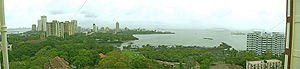
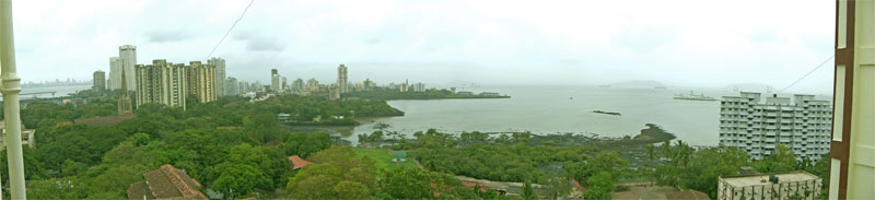
A view of Mumbai harbour looking northwest Location Country India Coordinates 18°56.3′N 72°45.9′E / 18.9383°N 72.765°E[1] Details Operated by Mumbai Port Trust Owned by Government of India Available berths 63[2] Wharfs 5 Statistics Annual cargo tonnage Bulk: 57.04 million tons (2007-08)[1] Annual container volume 118,000 TEU (2007-08) Website mumbaiport.gov.in Mumbai Port, earlier known as Bombay Port, lies midway (Latitude 18° 56.3' N, Longitude 72° 45.9' E) on the West coast of India, on the natural deep-water harbor of Mumbai. The harbor spread over 400 square kilometres (150 sq mi) is protected by the mainland of Konkan to its east and north and by the island city of Mumbai to its west.[1] The harbour opens to the south to the Arabian Sea.
The port is administered by the Mumbai Port Trust (MbPT), an autonomous corporation wholly owned by the Government of India.[3] The port is primarily used for bulk cargo, while most container traffic is directed to Nhava Sheva port across the harbor.
History
Mumbai Harbour has been used by ships and boats for centuries. It was used by the Maratha Navy, as well as the British and Portuguese colonial navies.
The first of the present-day docks of the Mumbai Port were built in the 1870s.[1] Bombay Port Trust (BPT) was established as a corporation on June 26, 1873.[4] BPT's founding chairman was Colonel J.A. Ballard. From its establishment, the port has been the gateway to India, and was a primary factor in the emergence of Mumbai as the commercial capital of India. The port and the corporation took their present names in the 1990s.
Over the decades, the port underwent tremendous expansion, with the addition of berths and cargo handling capacities. However, Mumbai's expanding growth and population pressure constrained the growth of the port by the 1970s. This led to the establishment of the Nhava Sheva port across Mumbai Harbour in Navi Mumbai on the Konkan mainland. Nhava Sheva begain operations in 1989, and most container traffic now flows through Nhava Sheva.
Mumbai Port handled over 57 million tonnes of cargo during 2007-2008. Cruise liners visiting Mumbai usually dock at the Ballard Pier Extension of Mumbai Port.
Facilities
Mumbai Port has three enclosed wet docks. Prince's Dock was commissioned in 1880. As of 2008, it has 8 berths with a minimum draft of 6.4 metres (21 ft). Victoria Dock, commissioned in 1891, had 14 berths as of 2008 with a minimum draft of 6.7 metres (22 ft). Indira Dock, commissioned in 1914, had 21 berths, with a minimum draft of 7.0 metres (23.0 ft). Prince's Dock and Victoria Dock are semi-tidal docks, with vessels docking and departing at high tide. Indira Dock has a lock, enabling vessels to enter or depart at any time.[2]
The port has four jetties on Jawahar Dweep, an island in the harbour, for handling Crude and petroleum products. These jetties have a draft of 12.2 metres (40 ft). Liquid chemicals are handled from a jetty on Pirpau.
Ballard Pier Extension has a passenger terminal, including immigration clearance facilities for crews and passengers of cruise liners.
The port has a total of 63 anchorage points. A pilot is mandatory for all vessels of over 100 tonnes net weightage.[5]
References
- ^ a b c d "Port Profile". Mumbai Port Trust. http://mumbaiport.gov.in/newsite/portinfo/Portprofile.htm. Retrieved 2011-09-23.
- ^ a b "Port Layout". Mumbai Port Trust. http://mumbaiport.gov.in/newsite/portinfo/Portprofile.htm#Port%20Layout. Retrieved 2011-09-23.
- ^ "Administration". Mumbai Port Trust. http://mumbaiport.gov.in/newsite/portinfo/administration.htm. Retrieved 2011-09-23.
- ^ http://www.indianexpress.com/res/web/pIe/ie/daily/19970626/17750073.html
- ^ http://mumbaiport.gov.in/newsite/services/facility.htm
Islands of Mumbai Harbour Categories:- Ports and harbours of Maharashtra
- Estuaries of Mumbai
Wikimedia Foundation. 2010.