- Nhava Sheva
-
Nhava Sheva 
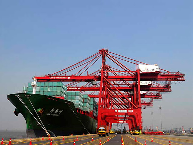
A container ship at Nhava Sheva Location Country India Coordinates 18°57′N 72°57′E / 18.95°N 72.95°E[1] Details Operated by Jawaharlal Nehru Port Trust Owned by Government of India Statistics Annual cargo tonnage Bulk: 7.88 million tons (2010-11)[2]
Container: 56.43 million tons (2010-11)Annual container volume 4.27 million TEU (2010-11) Website jnport.gov.in Nhava Sheva, officially Jawaharlal Nehru Port, is the 6th largest port and the largest container port in India.[3] Located in Maharashtra, the port on the Arabian Sea is accessed via Thane Creek.
Contents
History
Nhave Sheva is located on the Konkan mainland across from the island city of Mumbai. Spread over 10 square kilometres (2,500 acres), it was developed to relieve pressure on Mumbai Port.[4] It was inaugurated on May 26, 1989.
Construction of Nhava Sheva port was originally planned in 1965. The original plan envisioned the port for use to import food grains, since India then faced a major food shortfall. Following the Green Revolution in India, India gained vast surplus food grain production capacity. So the plans for the port shifted focus to container traffic.
Nhava Sheva port is run by the Jawaharlal Nehru Port Trust, an autonomous corporation wholly owned by the Government of India. The port was created to relieve pressure on Mumbai Port, then the pre-eminent port of India. It also enabled importers to avoid the octroi tax levied on goods entering Mumbai city by the Brihanmumbai Municipal Corporation, since it falls outside the jurisdication of the municipal corporation.
A ferry service operates between Nhava Sheva and the Gateway of India in downtown Mumbai. The Central Industrial Security Force is responsible for security of the port.
Nhava Sheva is well connected to major highways and rail networks in India. The closest suburban railheads are CBD Belapur and Panvel. The port handles 65% of India's container traffic has an average berthing period of 37 hours which is considered very long. The GTI terminal of the port has set national record for berth productivity of 235.92 moves/hour on 25th January 2010 on vessel M.V Ever Racer(WCIX service). The entire operation was performed in just 13 hours and 10 mins, during which 3295 moves (4136 TEUs) were performed.
The expansion plans for the port, include extensive new terminal access points and connecting roads.
Facilities
The JNPT Container Terminal is operated by JNPT. It has a quay length of 680 metres (2,230 ft) with 3 berths.[5]
The Nhava Sheva International Container Terminal (NSICT) is leased to a consortium led by P & O, now a part of DP World. Commissioned in July 2000, it has a 600 metres (2,000 ft) quay length with 2 berths. It can handle up to 15.6 million tons of cargo.[6] NSICT was India’s first privately managed container terminal.
The Gateway Terminal (GTI) has been leased to a consortium of APM Terminals and the Container Corporation of India. It started operations in 2006.[7]
The BPCL Terminal is leased to a joint-venture between Bharat Petroleum and Indian Oil. It mostly handles crude imports and refined petroleum products exports at its 2 berths.[6]
The port is well connected by rail and road to neighbouring Mumbai and to the rest of India.
Traffic
Major exports from Nhava Sheva are textiles, sporting goods, carpets, textile machinery, boneless meat, chemicals and pharmaceuticals. The main imports are chemicals, machinery, plastics, electrical machinery, vegetable oils and aluminium and other non-ferrous metals. The port handles cargo traffic mostly originating from or destined for Maharashtra, Madhya Pradesh, Gujarat, Karnataka, as well as most of North India.
See also
References
- ^ "Geographic Location". Jawaharlal Nehru Port Trust. http://jnport.gov.in/CMSPage.aspx?PageID=2. Retrieved 2011-09-23.
- ^ "Cummulative Traffic April 2010 to March 2011". Jawaharlal Nehru Port Trust. http://jnport.gov.in/writereaddata/Downloads/ANNEXURE%202010-11.pdf. Retrieved 2011-09-23.
- ^ http://business.rediff.com/slide-show/2010/oct/07/slide-show-1-the-major-ports-of-india.htm
- ^ Amit Mitra (2003-05-26). "Jawaharlal Nehru Port, Charting out a steady course". The Hindu Business Line. http://www.blonnet.com/bline/2003/05/26/stories/2003052600030100.htm. Retrieved 2009-08-18.
- ^ "JNPT Container Terminal". Jawaharlal Nehru Port Trust. http://jnport.gov.in/CMSPage.aspx?PageID=5. Retrieved 2011-09-23.
- ^ a b "NSICT Private Terminal". Jawaharlal Nehru Port Trust. http://jnport.gov.in/CMSPage.aspx?PageID=10. Retrieved 2011-09-23.
- ^ "Gateway Terminal". Jawaharlal Nehru Port Trust. http://jnport.gov.in/CMSPage.aspx?PageID=11. Retrieved 2011-09-23.
External links
- JNPT Nhavasheva Import Data
- [1] Laudable Achievements of JNPT
- [2] India - Nhava Sheva
- JNPT Nhavasheva Export Data
Categories:- Mumbai
- Navi Mumbai
- Ports and harbours of Maharashtra
Wikimedia Foundation. 2010.