- Mumbai Harbour
-
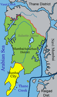
Mumbai Harbour — neighbourhood — Coordinates 18°58′N 72°51′E / 18.96°N 72.85°ECoordinates: 18°58′N 72°51′E / 18.96°N 72.85°E Country India State Maharashtra Time zone IST (UTC+05:30) Mumbai Harbour (Marathi: मुंबई बंदर Mumba'ī bandara), or Front Bay, is a natural deep-water harbor in the southern portion of the Ulhas River estuary. The narrower, northern part of the estuary is called Thane Creek. The harbor opens to the Arabian Sea to the south. The historical island of Elephanta is one of the six islands that lie in the harbor.
Front Bay is the official name of the harbor, so named because Mumbai started as a tiny settlement facing the harbor. The waterbody behind the original settlement, forming an arc between the former Colaba island and Bombay island, up to the Malabar Hill promontory or peninsula, was similarly called Back Bay.
Front Bay is home to the Mumbai Port, which lies in the south section of the western edge of the harbor. Jawaharlal Nehru Port and Navi Mumbai lie to the east on the Konkan mainland, and the city of Mumbai lies to the west on Salsette Island. The Gateway of India with its jetty for Elephanta is the most important tourist destination, followed by the INS Vikrant maritime Museum.
The Harbour Line of the Mumbai Suburban Railway system runs along the western edge of the harbor.
Contents
Islands
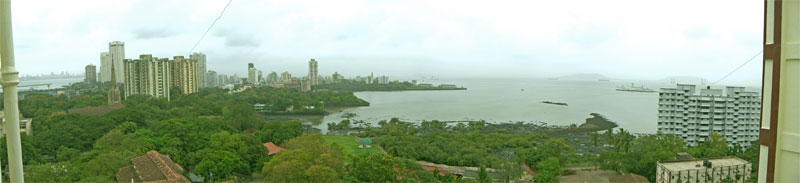
 The harbour east of the city
There are six islands in the Mumbai Harbor.[1]
Butcher Island, also known as Jawahar Dweep, is used as an oil terminal by the Mumbai Port. It has jetties for tankers and various other infrastructure for offloading crude oil and for loading refined petroleum products. The island is restricted to port employees, and not open to the public.
Cross Island is a small, uninhabited islet just off the coast of the Dockyard Road.
Elephanta Island, also known as Gharapuri Island, is the best known of the islands in Mumbai Harbor. The Elephanta Caves located on the island are a UNESCO World Heritage Site. The group of five larger caves have intricate Hindu religious rock sculptures. Two smaller caves have Buddhist religious sculptures. The carvings date back to between 5th and 8th centuries.
Middle Ground is a small islet in the Thane creek. It features an antique coastal gun battery of the Indian Navy. The guns salute Indian naval vessels returning from deployments when they enter the harbor.
Oyster Rock is a small group of rock outcroppings in the harbor. The area has restricted access since it is used for naval exercises.
Salsette Island is the large island on which the cities of Mumbai and Thane are located. It is separated from the Konkan mainland by the Vasai creek and the Ulhas river. Mumbai was originally a distinct island from Thane, but reclamation of land has long since merged the islands. Powai Lake, Tulsi Lake and Vihar Lake are the largest lakes on the island.
Mumbai Port
 A view of the harbour looking northwestMain article: Mumbai Port
Mumbai Port (MbPT) lies midway (18°56.3′N 72°45.9′E / 18.9383°N 72.765°E) on the western shore of Mumbai Harbour.[2] The port was the pre-eminent commercial port of India in the nineteenth and twentieth centuries. It is known as the gateway to India, and has been a primary factor in the emergence of Mumbai as the commercial capital of India.
Ecology
Mangrove swamps line much of the northwestern and eastern shores of the harbour, and provide a rich habitat for wildlife, including thousands of migrating birds such as flamingoes.
Pollution
Due to immense population pressures from the Mumbai metropolitan region and the extremely busy maritime trade, the Mumbai Harbour is considered to be heavily polluted.
This includes reports of heavy metals flux found in the creeks adjacent to the harbour with the harbour acting as a sink for most of the pollutants.[3]
References
- ^ "Islands of Mumbai". Indian Islands Tour. http://www.indianislandstour.com/islands_mumbai_harbour.htm. Retrieved 2011-09-23.
- ^ "Port Profile". Mumbai Port Trust. http://mumbaiport.gov.in/newsite/portinfo/Portprofile.htm. Retrieved 2011-09-23.
- ^ "IAPSO". Iugg.org. http://www.iugg.org/iapso/abstracts/IB-02/IB02-37.htm. Retrieved 2011-07-22.
External links
Islands of Mumbai Harbour Categories:- Estuaries of Mumbai
- Ports and harbours of Maharashtra


Wikimedia Foundation. 2010.