- Mueang Surin District
-
Mueang Surin
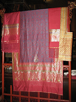
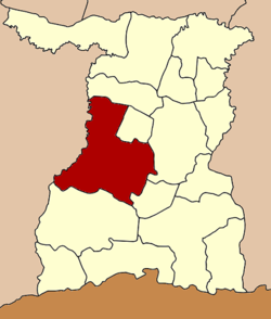
เมืองสุรินทร์— Amphoe — Tambon Tha Sawang Silk, well-known handicraft of Amphoe Mueang Surin Amphoe location in Surin Province Coordinates: 14°52′54″N 103°29′36″E / 14.88167°N 103.49333°ECoordinates: 14°52′54″N 103°29′36″E / 14.88167°N 103.49333°E Country  Thailand
Province Surin Seat Nai Mueang Area – Total 915.1 km2 (353.3 sq mi) Population (2008) – Total 257,845 – Density 281.1/km2 (728/sq mi) Time zone THA (UTC+7) Postal code 32000 Geocode 3201 Mueang Surin (Thai: เมืองสุรินทร์) is the capital district (Amphoe Mueang) of Surin Province, northeastern Thailand.
Contents
Geography
Neighboring districts are (from the north clockwise) Chom Phra, Khwao Sinarin, Sikhoraphum, Lamduan and Prasat of Surin Province, Krasang and Satuek of Buriram Province.
Administration
The district is subdivided into 21 subdistricts (tambon), which are further subdivided into 292 villages (muban). The town (thesaban mueang) Surin covers the whole tambon Nai Mueang. Mueang Thi is a subdistrict municipality (thesaban tambon) which covers parts of the tambon Mueang Thi. There are further 20 Tambon administrative organizations (TAO).
No. Name Thai Villages Inh.[1] 1. Nai Mueang ในเมือง - 40,295 2. Tang Chai ตั้งใจ 9 5,586 3. Phia Ram เพี้ยราม 16 7,728 4. Na Di นาดี 17 13,510 5. Tha Sawang ท่าสว่าง 21 16,450 6. Salakdai สลักได 16 11,001 7. Ta Ong ตาอ็อง 16 10,563 9. Samrong สำโรง 15 9,275 10. Kae Yai แกใหญ่ 13 9,226 11. Nok Mueang นอกเมือง 22 30,442 12. Kho Kho คอโค 12 10,067 13. Sawai สวาย 14 13,024 14. Chaniang เฉนียง 20 11,764 16. Thenmi เทนมีย์ 14 10,941 18. Na Bua นาบัว 19 12,554 19. Mueang Thi เมืองที 14 10,741 20. Ram ราม 13 8,929 21. Bu Rue Si บุฤาษี 10 6,939 22. Trasaeng ตระแสง 12 7,291 25. Salaeng Phan แสลงพันธ์ 9 6,155 26. Ka Ko กาเกาะ 12 5,364 Missing numbers now form the district Khwao Sinrin.
References
- ^ "Population statistics 2008". Department of Provincial Administration. http://www.dopa.go.th/xstat/p5132_01.html.
External links
- amphoe.com (Thai)
Mueang Surin · Chumphon Buri · Tha Tum · Chom Phra · Prasat · Kap Choeng · Rattanaburi · Sanom · Sikhoraphum · Sangkha · Lamduan · Samrong Thap · Buachet · Phanom Dong Rak · Si Narong · Khwao Sinarin · Non Narai
Categories:- Amphoe of Surin
Wikimedia Foundation. 2010.


