- Mueang Si Sa Ket District
-
Mueang Sisaket
เมืองศรีสะเกษ— Amphoe — Amphoe location in Sisaket Province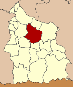
Coordinates: 15°7′14″N 104°19′20″E / 15.12056°N 104.32222°ECoordinates: 15°7′14″N 104°19′20″E / 15.12056°N 104.32222°E Country  Thailand
Province Sisaket Seat Mueang Nuea Area - Total 576.366 km2 (222.5 sq mi) Population (2009) - Total 135,512 - Density 233.9/km2 (605.8/sq mi) Time zone THA (UTC+7) Postal code 33000 Geocode 3301 Mueang Sisaket (Thai: เมืองศรีสะเกษ) is the capital district (Amphoe Mueang) of Sisaket Province, northeastern Thailand.
Contents
Etymology
Thai honorific Si is derived from the Sanskrit title of veneration Sri; Sisaket is sometimes transliterated as Srisaket, Sri Saket, Si Saket or Si Sa Ket.
History
The district was renamed from Klang Sisaket (กลางศีร์ษะเกษ) to Mueang Sisaket in 1913.[1] 1917 the Mueang was removed from the name,[2] which was added again in 1938.[3]
Geography
Neighboring districts are (from the north clockwise) Yang Chum Noi, Kanthararom, Nam Kliang, Phayu, Wang Hin, Uthumphon Phisai and Rasi Salai.
Administration
The district is subdivided into 18 subdistricts (tambon), which are further subdivided into 166 villages (muban). The town (thesaban mueang) Sisaket covers the tambon Mueang Nuea and Mueang Tai and parts of tambon Nong Khrok, Phon Kha, Ya Plong and Pho. Nam Kham is a subdistrict municipality (thesaban tambon) which covers the whole same-named subdistrict. There are further 15 Tambon administrative organizations (TAO).
No. Name Thai Villages Inh.[4] 1. Mueang Nuea เมืองเหนือ - 8,631 2. Mueang Tai เมืองใต้ - 10,346 3. Khu Sot คูซอด 10 4,889 4. Sam ซำ 14 6,810 5. Chan จาน 12 6,857 6. Tadop ตะดอบ 8 6,495 7. Nong Khrok หนองครก 9 15,015 11. Phon Kha โพนข่า 10 6,729 12. Phon Kho โพนค้อ 6 2,899 15. Phon Khwao โพนเขวา 11 7,648 16. Ya Plong หญ้าปล้อง 8 7,733 18. Thum ทุ่ม 13 6,928 19. Nong Hai หนองไฮ 7 3,778 21. Nong Kaeo หนองแก้ว 12 6,439 22. Nam Kham น้ำคำ 15 10,136 23. Pho โพธิ์ 10 13,526 24. Mak Khiap หมากเขียบ 11 4,871 27. Nong Phai หนองไผ่ 10 5,782 Missing numbers are tambon which now form the districts Wang Hin and Phayu.
References
- ^ "แจ้งความกระทรวงมหาดไทย เรื่อง เปลี่ยนนามอำเภอ" (in Thai). Royal Gazette 30 (0 ง): 1536–1537. 1913-10-12. http://www.ratchakitcha.soc.go.th/DATA/PDF/2456/D/1536.PDF.
- ^ "ประกาศกระทรวงมหาดไทย เรื่อง เปลี่ยนชื่ออำเภอ" (in Thai). Royal Gazette 34 (0 ก): 40–68. 1917-04-29. http://www.ratchakitcha.soc.go.th/DATA/PDF/2460/A/40.PDF.
- ^ "พระราชกฤษฎีกาเปลี่ยนนามจังหวัด และอำเภอบางแห่ง พุทธศักราช ๒๔๘๑" (in Thai). Royal Gazette 55 (0 ก): 658–666. 1938-11-14. http://www.ratchakitcha.soc.go.th/DATA/PDF/2481/A/658.PDF.
- ^ "Population statistics 2009". Department of Provincial Administration. http://www.dopa.go.th/xstat/p5233_01.html.
External links
- amphoe.com (Thai)
Sisaket Main article Capital Districts (amphoe) Mueang Sisaket · Benchalak · Bueng Bun · Huai Thap Than · Kantharalak · Kanthararom · Khukhan · Khun Han · Mueang Chan · Nam Kliang · Non Khun · Phayu · Pho Si Suwan · Phrai Bueng · Phu Sing · Prang Ku · Rasi Salai · Si Rattana · Sila Lat · Uthumphon Phisai · Wang Hin · Yang Chum Noi
Related topics Si Saket FC · Mun River · Chi River · Northern Khmer people · Preah Vihear Temple · 2008 Cambodian-Thai stand-off
Neighboring areas Thailand: Surin · Roi Et · Yasothon · Ubon Ratchathani ·
Cambodia: Oddar Meancheay · Preah VihearCategories:- Amphoe of Sisaket
- Isan geography stubs

Wikimedia Foundation. 2010.