- Mount Washington, Cincinnati
-
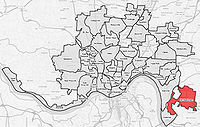
Mount Washington Mount Washington is a neighborhood of Cincinnati, Ohio. Mount Washington is a neighborhood on the east side of Cincinnati, Ohio, United States. It is located about ten minutes east of Downtown via Columbia Parkway and Beechmont Avenue; or a slightly longer drive via Riverside Drive (formerly Eastern Avenue) and Kellogg Avenue, to Salem Avenue and up Sutton Avenue or Beacon Street. As one of Cincinnati's 52 neighborhoods, Mount Washington lies within the city corporation limits, and borders the Cincinnati neighborhoods of California, Linwood, and the East End, as well as unincorporated Anderson Township, Hamilton County, Ohio. Mount Washington, originally an independent community, was annexed by the City of Cincinnati in 1911.
Contents
Business district
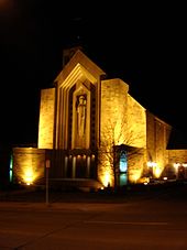
The Mount Washington Water Tower, located on Campus Lane between Beechmont Avenue and Sutton Avenue, is a noted Art Deco landmark and is decorated top-to-bottom with lights every Christmas. Mount Washington is home to numerous small businesses, many of them located along Beechmont Avenue / Ohio State Route 125 in the main neighborhood business district, "The Mount Washington Water Tower District" (sometimes referred to as "Uptown" as a means of distinguishing it from other business districts, including Downtown Cincinnati and the two other districts in Mount Washington).
Businesses include Mt. Washington Beer and Ice, two jewelry stores, and Mr. Lock locksmith, as well as local outlets of New York NY Deli Cafe, Wendy's, LaRosa's Pizza, National City Bank, Fifth Third Bank, Walgreens, and Kroger (headquartered in Cincinnati). Gold Star Chili was started in Mount Washington with the purchase of Hamburger Heaven in 1965, although the original location no longer exists. A recipe for Cincinnati chili was included in the sale. In season, there is also a community Farmer's Market on Thursdays in Stanbery Park.
Beechmont Avenue controversy
Beechmont Avenue in western Mount Washington was, prior to the 2002-2003 widening, featured reversible lanes. When the street was widened, two additional lanes were added between the western Corporation Line and Wasigo Drive (to create a dual turn lane), with one additional lane between Wasigo Drive and Corbly Street. Sidewalks and curbs were also added along the route.
With the widening came wider lanes and higher speeds. The new roadway was designed with 12-foot-wide (3.7 m) lanes, common on many high speed roadways and expressways. Furthermore, traffic has greatly increased along the route. The neighborhood and the City of Cincinnati Department of Transportation and Engineering are working to correct the deficiencies in the design through traffic calming.
Housing
Throughout the 1980s, the growth of large apartment complexes, and low to moderate income apartment buildings strained the neighborhood's image. Recent zoning has helped to protect the mostly residential nature of Beechmont Avenue in Mount Washington.
Mount Washington contains historic homes and distinctive architecture, particularly on Beacon Street, Mears Avenue, Wilaray Terrace and Beechmont Avenue. Housing stock in the neighborhood is diverse, with values ranging from modest bungalows to million dollar estates. Wilaray Terrace, Honeysuckle Lane, and Honeysuckle Drive are lined with architect-designed homes, built from the 1920s to early 1960s. Other streets, such as Adena Trail, contain homes built throughout the later twentieth century. The Lower Salem area, located along Salem Avenue between Wayside and Kellogg Avenues, contains sprawling estates and large homes. Ambar Avenue hosts an annual street party and events sponsored by residents.[citation needed]
Schools
Three grade schools are located in Mount Washington:
- Sands Montessori (Corbly Street, Cincinnati Public Schools), formerly housing the Eastern Hills Elementary and Junior High Schools,
- Mt. Washington Elementary School (Mears Avenue, Cincinnati Public Schools),
- Guardian Angels School (6539 Beechmont Avenue, Roman Catholic Archdiocese of Cincinnati). The Guardian Angels Campus, constructed in 1931, 1942, 1949, and 1963–1971, was designed by architect Edward J. Schulte.
The Archbishop McNicholas High School (Roman Catholic Archdiocese of Cincinnati) is also located in Mount Washington, across from Guardian Angels.
Mount Washington is also home to The Athenaeum of Ohio (Mt. St. Mary's Seminary of the West), located at the eastern gateway to Mount Washington, the intersection of Beechmont Avenue and Burney Lane. The campus is owned by the Archdiocese of Cincinnati and is known for its architecture. Many of the records for the Archdiocese of Cincinnati are located at the campus library.
Parks
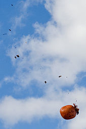
Cincinnati Park Board operates the 125-acre (0.51 km2) Stanbery Park on Oxford Avenue between Corbly Street and Crestview Place. This park is named after Brigadier General Sanford B. Stanbery, who was the highest ranking officer from Hamilton County in World War I. The Tudor-style Stanbery house used to be located on park grounds, but was demolished as part of a park improvement program. Fundraisers held at the park have included a "Pumpkin Chuck" using a trebuchet (after Halloween, in 2006 through 2010). The park facilities include a paved walking area, hiking trails, playground equipment, and a picnic shelter. Stanbery Park is a popular sledding area on snowy days.
Recent development
- New retail development by COLE Realty Associates at the intersection of Roxbury Street and Beechmont Avenue, including streetscape improvements, which will house a new St. Vincent de Paul thrift Store
- Condominium development on Elstun Road
- Six new single-family homes to be built on Honeysuckle Drive
References
External links
- Mount Washington Community Council
- Guardian Angels School
- Mount Washington Baptist Church and Daycare
- City of Cincinnati
- Mount Washington Elementary School
Coordinates: 39°05′15″N 84°23′11″W / 39.0875°N 84.38639°W
City of Cincinnati Neighborhoods Avondale · Bond Hill · California · Camp Washington · Carthage · Clifton · College Hill · Columbia-Tusculum · Corryville · CUF · Downtown · East End · East Walnut Hills · East Westwood · English Woods · Evanston · Fay Apartments · Hartwell · The Heights · Hyde Park · Kennedy Heights · Linwood · Madisonville · Millvale · Mount Adams · Mount Airy · Mount Auburn · Mount Lookout · Mount Washington · North Avondale · North Fairmount · Northside · Oakley · Over-the-Rhine · Paddock Hills · Pendleton · Pleasant Ridge · Price Hill · Queensgate · Riverside · Roselawn · Sayler Park · Sedamsville · South Cumminsville · South Fairmount · Spring Grove Village · Walnut Hills · West End · Westwood · Winton Hills
History Sports ProfessionalCollegeHigh schoolTournamentsVenuesBaseball parks · Cintas Center · Cincinnati Gardens · Cincinnati Tennis Club · Fifth Third Arena · GABP · Lindner Family Tennis Center · Paul Brown Stadium · U.S. Bank ArenaEducation Public school districtsUniversities & collegesAAC · AIC · MTSM · CCU · CCMS · Cincinnati State · UC · Mount St. Joseph · GBS · HUC-JIR · National College · Union · XavierEducation centersOtherCategories:- Neighborhoods in Cincinnati, Ohio
Wikimedia Foundation. 2010.


