- Mount Victoria, Maryland
-
Mount Victoria — Unincorporated community — Location within the state of Maryland
 Mount Victoria
Coordinates: 38°21′12″N 76°53′45″W / 38.35333°N 76.89583°WCoordinates: 38°21′12″N 76°53′45″W / 38.35333°N 76.89583°W Country United States State Maryland County Charles Time zone Eastern (EST) (UTC-5) - Summer (DST) EDT (UTC-4) ZIP codes FIPS code GNIS feature ID 590846 Mount Victoria is an unincorporated community in southern Charles County, Maryland, United States, between the Wicomico and Potomac Rivers.[1] It was named for an enormous farm of 15,000 acres (61 km2) owned by Robert Crain, an attorney and farmer whose lobbying efforts led to the opening in 1927 of the Maryland portion of U.S. Highway 301. This farm was said at the time to be the largest private landholding in Maryland.
References
Municipalities and communities of Charles County, Maryland Towns 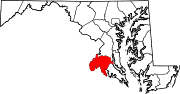
CDPs Other
communitiesBel Alton | Benedict | Bryantown | Cobb Island | Dentsville | Faulkner | Ironsides | Issue | Malcolm | Marbury | Masons | Morgantown | Mount Victoria | Nanjemoy | Newburg | Newport | Patuxent | Pisgah | Pomfret | Popes Creek | Pomonkey | Ripley | Rison | Riverside | Rock Point | Swan Point | Welcome | White Plains
Categories:- Maryland geography stubs
- Populated places in Charles County, Maryland
- Unincorporated communities in Maryland


Wikimedia Foundation. 2010.