- Mollie, Indiana
-
Mollie — Extinct village — Location of Mollie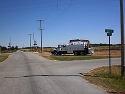

 Mollie
Coordinates: 40°30′30″N 85°18′54″W / 40.50833°N 85.315°WCoordinates: 40°30′30″N 85°18′54″W / 40.50833°N 85.315°W Country United States State Indiana County Blackford Township Harrison Elevation[1] 869 ft (265 m) Population (1980) - Total 5 Time zone EST (UTC-5) - Summer (DST) EDT (UTC-4) ZIP code 47348 Area code(s) 765 Mollie is an extinct American village in Blackford County, Indiana, that flourished during the Indiana Gas Boom from the 1880s until the 1920s. The region around Mollie experienced an economic "boom" period because of the discovery of gas and crude oil. Mollie was a stop along the Fort Wayne, Cincinnati, and Louisville Railroad — and happened to be near the region's oil fields, a convenient location for the area's oil workers.
Mollie's location on the railroad line was approximately half-way between the two largest cities in Blackford County: Hartford City and Montpelier. In addition to the oil fields, the area was also fertile farmland. Two county roads intersected at Mollie, making it well-located for area farmers as well as the oil workers. The small community had a feed mill, a grocery, a Post Office, and a livestock station. The sole manufacturing facility was a brick and tile mill. Mollie's significance, in addition to its participation in the Indiana Gas Boom and its railroad station, is that Mollie is thought to be the site of the first aircraft landing in Blackford County.[2]
Most of the small community's growth and demise is linked to the Indiana Gas Boom. Two other factors were minor contributors to Mollie's decline. First, the depletion of the raw material used in the community’s tile manufacturing factory meant that Mollie lost its only manufacturer. A second factor was the automobile. Improvements in modern highway systems, automobile reliability, and automobile availability made people less dependent on railroads for transportation — diminishing Mollie's value as a stop along a railroad line.
Today (2011), none of the community’s commercial buildings remain. Two houses are located nearby — including one that was built using bricks made from the community's tile mill. Interurban lines declined in popularity in Indiana during the 20th century, and a line serving Mollie was removed in the 1940s. Although the track that was the Mollie railroad spur is gone, freight trains operated by the Norfolk Southern Railway still operate over the adjacent main line.
Contents
History
The small East Central Indiana village named Mollie was located in the Harrison Township section of Blackford County, at the intersection of county roads 400 North and 300 East.[3] A railroad line passes very close to the intersection. A former resident, interviewed in 1972, believes the community was named after an early resident named Mollie, but she cannot recall Mollie's surname.[4] The community was essentially a small informal cluster of houses around a train station, and it was never officially platted.[4]
Gas boom
In 1887, natural gas was discovered in nearby Hartford City, and Blackford County began its participation in the Indiana Gas Boom.[5] More importantly for Mollie, oil was discovered north of Hartford City in Harrison Township. Blackford County's first oil well began producing during 1890 in Harrison Township south of Montpelier, Indiana (which is north of Mollie).[6] By the mid-1890s, about two thirds of Harrison Township (25 square miles) was considered part of an oil-producing region.[6] Nearby Montpelier was thought to be "the very heart of the greatest natural gas and oil field in the world".[7] Mollie's location along Blackford County's north-south railroad line is about 4.5 miles (7.2 km) from Hartford City and 3.6 miles (5.8 km) from Montpelier.[8] During the Indiana Gas Boom, Mollie's location was ideal for men working in nearby oil fields.[9] Thus, Mollie had the fortune during the 1890s of being located between two boomtowns, having an oil field nearby, and having railroad service.
Post office
Mollie's Post Office was established October 19, 1888. Henry H. Dean was the first postmaster, and this Post Office lasted for about one year before it was discontinued.[10] The Post Office re-started on February 6, 1890, with Anderson Hatfield as the postmaster. It was housed in the front of Jacob Burnworth's grocery store. This Post Office became especially useful for workers in the nearby oil fields because mail could be easily sent and retrieved using the railroad. Although the grocery building burnt to the ground in 1891, the facility was rebuilt.[4] The United States Official Postal Guide lists the Mollie Post Office as one of seven Post Offices in Blackford County during 1895.[11] In addition to the Post Office, the grocery building had a small waiting room for railroad passengers.
Mollie's Post Office was discontinued in February 1907, and area mail began being handled by nearby Hartford City's Post Office.[12] Although the Mollie Post Office was busy during the earlier years when the Blackford County oil field operations were significant, Postmaster Jacob Burnworth felt that decreased business made it a "waste of time" to continue. Despite the closing of the Mollie Post Office, the grocery housed in the same building continued, as did the waiting station for the interurban that was also located in the building. In 1914, burning soot caused the grocery store building to burn to the ground.[13]
Aircraft landing
Near the end of World War I, an army biplane was forced to land near Mollie because of engine failure. This was exciting news in Blackford County, and people paid to ride the trolley (interurban line) to Mollie to see the aircraft. A county historian believes this was one of the first, if not the first, aircraft to land in Blackford County.[2]
Geography
Mollie is considered part of East Central Indiana and Northern Indiana. It is located about 44 miles (71 km) south of Fort Wayne, Indiana, and about 71 miles (114 km) northeast of Indianapolis.[14]
Beneath the soil of Mollie lies the Trenton Oil and Gas Field responsible for the Indiana Gas Boom.[15] Oil production from the Trenton Field, which affected Mollie more than the production of natural gas, peaked around 1904.
Future Northern Indiana, including what became Harrison Township and Mollie, was flattened by two glaciers millions of years ago.[16] These glaciers are also responsible for the rich Blackford County farmland, which includes the land surrounding Mollie.[17] "Standard cereals, wool and live stock" were the products of the area farms during Mollie's more prosperous years in the 1890s.[6] One hundred years later, the region is still agriculture-oriented. Soybeans and corn are the most popular crops grown in Blackford County, and over 65,000 acres (260 km2) (60%) are devoted to these two crops according to a survey from the 1990s. [18] Additional crops and livestock are also grown in Blackford County.
Climate
Mollie has a typical Midwestern humid continental seasonal climate. There are four distinct seasons, with winters being cold with moderate snowfall, while summers can be warm and humid. The highest average temperature is in July at 84 °F (29 °C), while the lowest average temperature is in January at 18 °F (−8 °C). However, summer temperatures can top 90 °F (32 °C), and winter temperatures can drop below 0 °F (−17 °C). Average monthly precipitation ranges from 2 to 4 inches (51 to 100 mm), with the heaviest occurring during June, July, and August. The highest recorded temperature was 103.0 °F (39.0 °C) on June 26, 1988, and the lowest recorded temperature was −26.0 °F (−32.0 °C) on January 19, 1994.
Climate data for Montpelier, Indiana — which is 3.5 miles (6 km) north of Mollie, Indiana Month Jan Feb Mar Apr May Jun Jul Aug Sep Oct Nov Dec Year Average high °F (°C) 33
(1)38
(3)49
(9)62
(17)72
(22)81
(27)84
(29)82
(28)76
(24)65
(18)50
(10)38
(3)60.8
(16.0)Average low °F (°C) 18
(−8)22
(−6)31
(−1)41
(5)50
(10)60
(16)63
(17)62
(17)54
(12)43
(6)34
(1)23
(−5)41.8
(5.4)Precipitation inches (mm) 1.96
(49.8)1.94
(49.3)2.79
(70.9)3.37
(85.6)3.81
(96.8)4.33
(110)4.28
(108.7)4.05
(102.9)2.88
(73.2)2.48
(63)3.37
(85.6)2.70
(68.6)37.96
(964.2)Source: The Weather Channel[19] Demographics
Milestone years in Mollie's history are 1870, when the railroad line was completed; 1878, when leading-citizen Jacob Burnworth moved to Blackford County; 1888, when the Mollie Post Office opened; 1890, when the first oil well was successfully drilled between Montpelier and Mollie; and 1907, when the Mollie Post Office closed because of the end of the Gas (and oil) Boom. These events outline the rise, and the beginning of the decline, of the community. Population patterns can be expected to follow this outline.
Census information is not directly available for Mollie. Residents of Mollie were counted as part of Blackford County's Harrison Township, and the "Name of incorporated city, town, or village, within the above named division" heading on the census page was left blank. The population in 1890 for the entire Harrison Township less the city of Montpelier was 1,900. This would include farms, Mollie, and other small villages similar to Mollie. For the year 1900, the census lists the population for Harrison Township less the city of Montpelier as 1,867.[20] Based on entries in a county directory, Mollie was populated by at least 15 households in 1902.[21] Using the Mollie households listed in the county directory, and census counts for each matching Harrison Township household, Mollie's unofficial population must have exceeded 55 in 1900.[22] The 1900 Census is probably the census that is closest to Mollie's peak year for population. The oil part of the Indiana Gas Boom was just beginning in 1890, and the boom was already over by 1910 — as evidenced by the closing of the Mollie Post Office in 1907. Mollie's population has been estimated to have a peaked around 25 during the 1920s, less than half of the probable population in 1900.[4] Over the next 50 years the population continued to decline, and by the 1970s, Mollie consisted of just two houses. Mollie's population in 1972 was 4 — increasing to 5 people in 1980.[4][3]
Economy
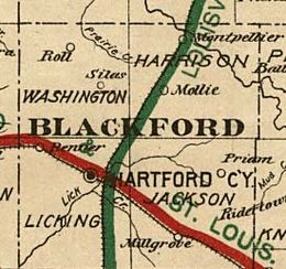 Mollie in Blackford County portion of 1890s railroad map.
Mollie's economy was centered on its railroad stop and agriculture. Mollie had a grain elevator, and grain and hay raised by area farmers were shipped out via the railroad. Mollie’s railroad facility, and the Mollie stockyard, were used by area farmers to ship livestock. Farmers on horseback, and on foot, would drive cattle or hogs down the county roads to Mollie's stockyard. Livestock were typically shipped to stockyards in New York or Chicago.[10] Some livestock, such as lambs from the west, also came into Mollie by rail.[10]
Mollie's only manufacturing facility was a tile mill.[23] Drainage tiles were important in Blackford County during the 19th century because of the original swampy condition of the land.[24] The tile mill manufactured drain tile, building blocks, and bricks. At least one of the two houses still standing in the Mollie was built by using bricks from the local tile factory.[4] Tile mill products could easily be shipped on the nearby railroad.
Other businesses in Mollie included the general store, a cider mill, and a blacksmith shop. These businesses had extra demand for their services during the Indiana Gas Boom, when numerous oil field workers worked nearby.
Infrastructure
Mollie is located at the intersection of county roads 400 North and 300 East. A railroad passes very close to the intersection. During the late 19th Century and early 20th Century, passenger and freight trains stopped in the small community. A grain elevator and stockyard were located nearby, serving the area farmers. Livestock was transported to and from the area. Other buildings in Mollie included the tile factory, grocery store, cider mill, and a blacksmith shop. In later years, the grocery store was described as a “general store”.[25] A community as small as Mollie could not justify having a hospital. However, Mollie had at least one registered physician, Doctor H. B. Reed.[26]
Railroad
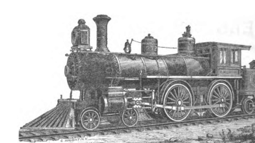
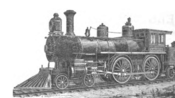 An 1890s locomotive.
Located in Mollie next to the intersection of the two county roads is a railroad line. This line was authorized in 1849, and connects the Indiana cities of Fort Wayne and Muncie — running through the Blackford County communities of Montpelier, Mollie, and Hartford City (see railroad map).[27] Although work constructing the railroad line began in the 1850s, it was not completed (by connecting Fort Wayne to Muncie) until 1870.[27] The original company was named Fort Wayne & Southern Railroad Company, but by the time the railroad began operations, it was named Fort Wayne, Cincinnati & Louisville Railroad. (Most of the "Louisville" part of the name can be seen on the railroad map herein.)[27] The Lake Erie and Western Railroad acquired the Fort Wayne, Cincinnati & Louisville Railroad in 1890, and both names were used to describe the railroad during Mollie's more prosperous years.[28][29] A short piece of railroad track branched off from the main line to enable the loading and unloading of railcars in Mollie. The Mollie "loading track" was listed in 1895 as having a length of 361 feet (110 m).[30] Another short branch line, the 800-foot (240 m) Manhattan Oil spur, was located nearby. Although these branch lines have been removed, trains still operate over the main line.
Around 1905, an interurban line began running parallel to the railroad. The interurban, called the trolley by the locals, connected with Montpelier to the north and Hartford City to the south.[31] Automobiles gradually replaced interurbans as the popular choice for passenger transportation. Blackford County's interurban was removed in the early 1940s.[32]
Notable people
Mollie's leading resident during the Indiana Gas Boom era was Jacob Burnworth, who moved to Blackford County in 1878.[33] Burnworth also owned Mollie's two major enterprises: the grocery store and the tile factory. The building that housed the grocery also had additional purposes. The Mollie store also housed a small waiting station for the interurban and a Post Office. Burnworth served as a the Mollie post master, and he was also a Justice of the Peace for Harrison Township.[33][12] He died in 1917 at the age of 76.[34][35]
Decline
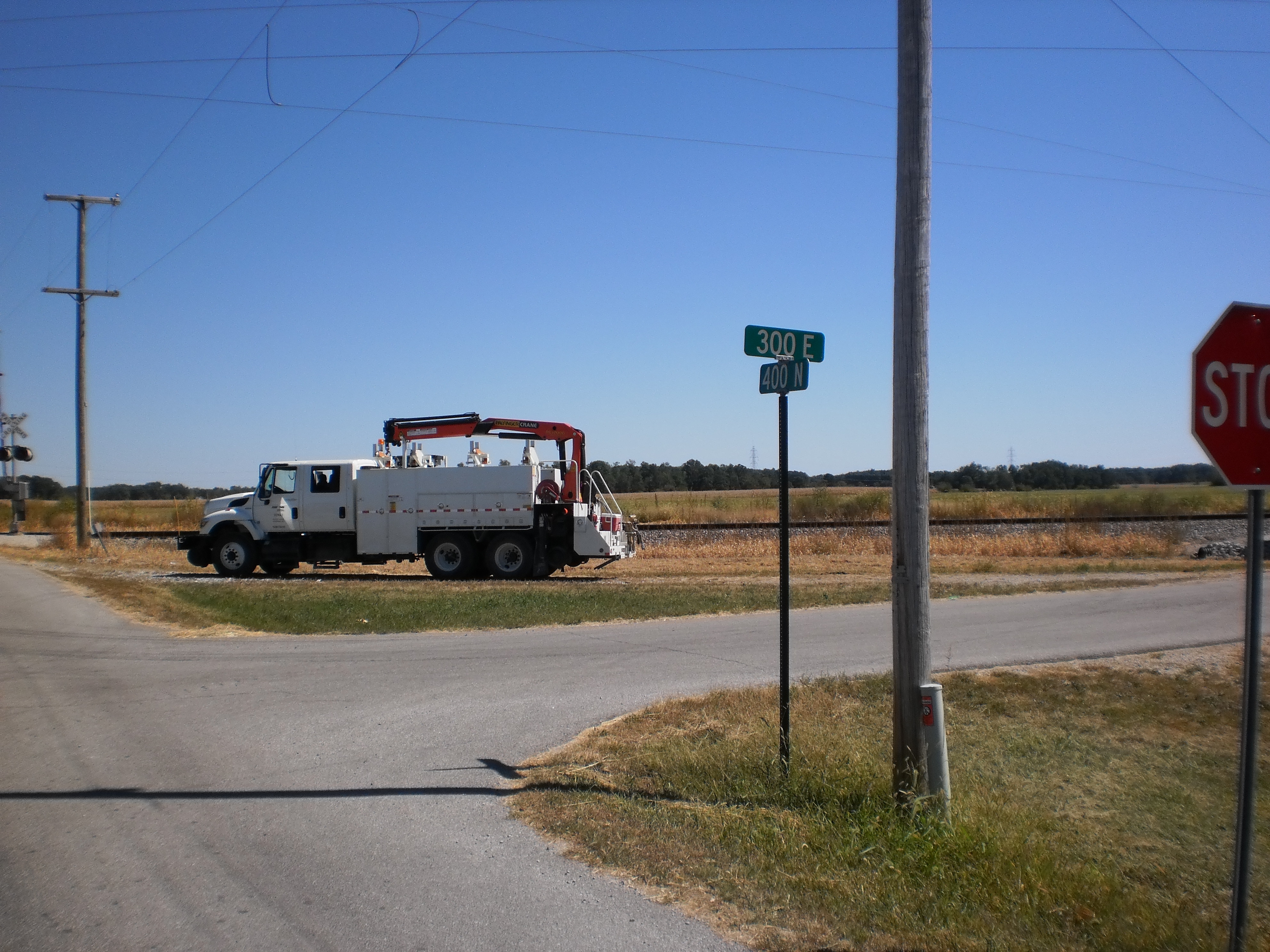
 Site of extinct village named Mollie
At the beginning of the 20th century, the Indiana Gas Boom gradually came to an end.[36] The end of the Gas Boom was difficult for many small communities, and it was a major cause of Mollie's decline. Unlike some communities, Mollie did not have manufacturers that were dependent upon the low-cost energy provided by the abundant natural gas. However, the loss of the oil workers in the nearby Harrison Township oil fields meant that consumer demand in Mollie was significantly diminished. By 1907, Mollie's Post Office was discontinued because of lack of demand — the oil workers had moved away. Elsewhere in the county, the gas and oil workers left, some of the manufacturers moved, and some of the service industries were forced to close or cut back. According to the United States Census, Blackford County's population peaked at 17,123 in 1900, and it still has not returned to that zenith 100 years later.[37] Mollie was still listed on maps during the 1920s, but its decline was already two decades old.[38]
Other contributers to Mollie's demise concerned Jacob Burnworth and his tile factory. Burnworth was Mollie's leading citizen and entrepreneur. He owned the town's general store (which also contained the interurban station}, and tile factory. The clay used by the tile factory became depleted, and the tile factory was moved to Hartford City.[4] Burnworth died August 12, 1917, at the age of 76.
A smaller factor to affect Mollie was the automobile. During the 20th Century, the quality of automobiles and roads improved — resulting in the decline of interurban lines and passenger service on the railroads. The last interurban train ran on January 18, 1941.[39] Passenger service on the Lake Erie and Western Railroad line (owned by the Nickel Plate Road by that time) had already been discontinued in 1931. Many small towns, including Mollie, had started as stops on railroad lines. The automobile contributed to the decline of the railroad as a major provider of passenger transportation. It also changed “business and shopping patterns at the expense of the small-town merchant”.[40]
In 1972, Mollie's population was down to 4 people, and the community consisted of two houses. A "Welcome to Mollie, pop. 4" sign was kept nearby for the amusement of passing motorists.[41]
Remains of the site
The land once occupied by the Mollie community, located at the intersection of Blackford County roads 400 North and 300 East, is now farmland and owned privately. All commercial buildings have been demolished. Although the interurban line is gone, the railroad line is still in service. Norfolk Southern Railway owns and operates the railroad line, which still connects the cities of Montpelier and Hartford City with each other and points throughout North America. (See photo — the track was undergoing maintenance work at the time the picture was taken.)
Notes
- ^ Based on nearby Montpelier, Indiana
- ^ a b Goodspeed's 1972 article in the Marion Chronicle-Tribune. The Goodspeed article was also quoted on page 117 of A History of Blackford County…, and the Blackford Wells Tracer (Volume 10, Issue 4, page 3) quoted the A History of Blackford County… article.
- ^ a b Monfort. (This 1980 article in the Hartford City News-Times misspelled "Mollie" as "Molly".)
- ^ a b c d e f g Goodspeed's 1972 article in the Marion Chronicle-Tribune.
- ^ A History of Blackford County..., p. 46.
- ^ a b c Blatchley, p. 71
- ^ A History of Blackford County..., p. 90, quoting the November 19, 1895 edition of the Montpelier Herald.
- ^ Goltra, p. 79. This page lists the distance for railroad sidings in Hartford City, Mollie, and Montpelier from Fort Wayne. Differences in those mileages can be used to calculate the approximate distance by railroad between the Blackford County communities.
- ^ Indiana State Board of Agriculture, page 279.
- ^ a b c A History of Blackford County..., p. 117.
- ^ United States Post Office Department, p. 580.
- ^ a b "A Postoffice is Wiped Out," Hartford City Evening News, February 7, 1907. (The article's headline spelled "Post Office" as "Postoffice".)
- ^ Two Fires Do $3,500 Damage.
- ^ Based on 4 miles south of Montpelier, and mileages from the Montpelier, Indiana web site.
- ^ See Rupp's Oil and Gas in Indiana web page.
- ^ A History of Blackford County..., pp. 8-9.
- ^ A History of Blackford County..., p. 10.
- ^ Purdue University's Indiana CropMAP web site.
- ^ "Montpelier Weather Records and Averages". Yahoo!. 2011. http://weather.yahoo.com/climo/USIN0439_f.html?woeid=2453515. Retrieved February 13, 2011.
- ^ Twelfth Census of the United States, Statistics of Population, Minor Civil Divisions, Table 5.
- ^ This is based on listings in Dale's Gazetteer less duplicate entries.
- ^ Dale's Gazetter and the Twelfth Census of the United States, State of Indiana, Blackford County, Harrison Township, Sheets 5 through 9.
- ^ This tile factory is pictured on page 117 of A History of Blackford County....
- ^ A History of Blackford County…, page 11. "At first there was much swampy undrained land in the county."
- ^ Two Fires Do $3,500 Damage. The store, owned by Jacob Burnworth, is called a general store instead of a grocery store in this 1914 newspaper article.
- ^ Indiana State Board of Medical Registration..., p. 71.
- ^ a b c Biographical and historical record of Jay and Blackford Counties...., pp. 759-760.
- ^ Goltra, p. 14.
- ^ The railroad changed ownership and names more than once, and was also known as the Lake Erie and Western Railroad, the Nickel Plate Road, and the Norfolk and Western Railway. It is currently (2011) part of the Norfolk Southern Railway. These names are discussed in A History of Blackford County…, pp. 18-19.
- ^ Goltra, p. 79.
- ^ Goodspeed. Goodspeed calls the interurban line a "trolley system".
- ^ A History of Blackford County…, p. 19.
- ^ a b Shinn, page 185. The Burnworth portion of Shinn's book has been reproduced on the web. (scroll down)
- ^ "Jacob Burnworth, 76, is Dead at Mollie," Hartford City Evening News, August 13, 1917.
- ^ Owen, p. 136.
- ^ Glass and Kohrman, page 91.
- ^ Forstall, p. 50.
- ^ Historic Map Works web page for Blackford County during 1920s.
- ^ A History of Blackford County..., p. 19.
- ^ McIlwraith and Muller, p. 336.
- ^ Goodspeed. A picture of the sign is included in Goodspeed's article. The sign is also displayed on page 117 of A History of Blackford County...
References
- A History of Blackford County, Indiana : with historical accounts of the county, 1838-1986 [and] histories of families who have lived in the county.. Hartford City, Indiana: Blackford County Historical Society. 1986. pp. 302. OCLC 15144953.
- "A Postoffice is Wiped Out", Hartford City Evening News, February 7, 1907
- Biographical and historical record of Jay and Blackford Counties, Indiana: Containing ... portraits and biographies of some of the prominent men of the state : engravings of prominent citizens in Jay and Blackford Counties, with personal histories of many of the leading families and a concise history of Jay and Blackford Counties and their cities and villages. Chicago: The Lewis Publishing Company. 1887. pp. 901. OCLC 15560416. http://contentdm.lib.byu.edu/cdm4/document.php?CISOROOT=/FH26&CISOPTR=36087&CISOSHOW=35182.
- Blatchley, W. S. (1897). Indiana Department of Geology and Natural Resources, Twenty-First Annual Report (1896). Indianapolis: Indiana Department of Geology and Natural Resources. pp. 718. OCLC 7536715. http://books.google.com/books?id=_w4MAAAAYAAJ&pg=PA71&dq=Blackford+This+county+comprises+but+165+square+miles&hl=en&ei=z4k_Tb24NcrcgQfqmJTUAg&sa=X&oi=book_result&ct=result&resnum=1&sqi=2&ved=0CCYQ6AEwAA#v=onepage&q=Blackford%20This%20county%20comprises%20but%20165%20square%20miles&f=false.
- Dale, George R. (1902). Directory of Hartford City, Indiana, Together with a Complete Gazetteer of Blackford County Land Owners. Troy, Ohio: George R. Dale. pp. 168. http://www.archive.org/stream/directoryofhartf19021903dale/directoryofhartf19021903dale_djvu.txt.
- Forstall, Richard L. (1996). Population of states and counties of the United States: 1790 to 1990: from the twenty-one decennial censuses. Washington, DC: U.S. Dept. of Commerce, Bureau of the Census, Population Division. pp. 225. ISBN 0934213488. OCLC 34927951. http://books.google.com/books?id=Z12v1lrkv2IC&pg=PA50&dq=Benton+Blackford+Boone+Brown+population+1870+1970&hl=en&ei=ntZETYX3O9P3gAeOrZy7AQ&sa=X&oi=book_result&ct=result&resnum=9&sqi=2&ved=0CFQQ6AEwCA#v=onepage&q&f=false.
- Glass, James A.; Kohrman, David (2005). The Gas Boom of East Central Indiana. Charleston, SC: Arcadia. pp. 128. ISBN 0738539635. OCLC 61885891. http://books.google.com/?id=C02PktLMIx8C&pg=PA91&lpg=PA91&dq=gas+boom+ghost+town+indiana.
- Goltra, W. F. (1895). Characteristics of the Lake Erie & Western Railroad System. Indianapolis: Press of Levey Bros. & Co.. pp. 102. OCLC 7147894. http://books.google.com/books?id=6VsrAAAAYAAJ&pg=PA79&dq=%22Mollie+loading+track%22&hl=en&ei=kLlBTcKANoPZgAfS9eiyAQ&sa=X&oi=book_result&ct=result&resnum=1&ved=0CCcQ6AEwAA#v=onepage&q=%22Mollie%20loading%20track%22&f=false.
- Goodspeed, Darrell (December 28, 1972), "“4” – Small town boasts of population", Marion Chronicle Tribune
- "Historic Map Works – Blackford County". Historid Map Works, LLC. circa 1920. http://www.historicmapworks.com/Atlas/US/21768/Blackford+County+192x/. Retrieved January 8, 2011.
- Indiana State Board of Agriculture; Indiana Geological Survey (1891). Annual report of the Indiana State Board of Agriculture. Indianapolis: State Board of Agruculture. pp. 543. OCLC 4948696. http://books.google.com/books?id=E44ZAQAAIAAJ&pg=PA279&lpg=PA279&dq=Montpelier+oil+fields+Indiana&source=bl&ots=J4WK45eB2M&sig=HpmHllE7BWgpTlLV_3DfxBtBb_I&hl=en&ei=giIqTZeFAsH_lgek4-W5AQ&sa=X&oi=book_result&ct=result&resnum=5&ved=0CDEQ6AEwBA#v=onepage&q&f=false.
- Indiana State Board of Medical Registration and Examination (1901). Annual report of the Indiana State Board of Medical Registration and Examination for the year ending December 31, 1900. Indianapolis: Wm. B. Burford. pp. 227. OCLC 16566746. http://books.google.com/books?id=dr1AAAAAYAAJ&pg=PA71&lpg=PA71&dq=%22Mollie%22+Blackford+Hartford&source=bl&ots=hncTSTHtUa&sig=xPzRGnl0ONyZTnbhMOO3tWCN2Og&hl=en&ei=rq4oTZGdLsP78AacsNj8AQ&sa=X&oi=book_result&ct=result&resnum=10&sqi=2&ved=0CE8Q6AEwCQ#v=onepage&q=%22Mollie%22%20Blackford%20Hartford&f=false.
- McIlwraith, Thomas F.; Muller, Edward K. (2001). North America: the historical geography of a changing continent. Lanham, Maryland: Lanham [u.a.] : Rowman & Littlefield. pp. 501. ISBN 0742500187. OCLC 248646178. http://books.google.com/books?id=8NS0OTXRlTMC&pg=PA336&lpg=PA336&dq=small+towns+railroads+automobile&source=bl&ots=-iR3FWujWX&sig=JkTD_humtNBMd4X39rbyv0jfsQk&hl=en&ei=Nx1PTfJjxqqUB-mErOgP&sa=X&oi=book_result&ct=result&resnum=10&ved=0CFQQ6AEwCQ#v=onepage&q=small%20towns%20railroads%20automobile&f=false.
- "Jacob Burnworth, 76, is Dead at Mollie", Hartford City Evening News, August 13, 1917
- Monfort, Bert (November 25, 1980), "Molly – Thanksgiving in a small town (population five)", Hartford City News-Times: page 6
- Owen, William D. (1898). Biennial Report of [the] Secretary of State of the State of Indiana. Indianapolis: Wm. B. Burford. pp. 453. OCLC 39817243.
- Purdue University Center for New Crops & Plants Production (July 1, 2000). "Indiana CropMAP". Purdue University. http://www.hort.purdue.edu/newcrop/cropmap/indiana/default.html. Retrieved February 12, 2011.
- Shinn, Benjamin Granville (1914). Blackford and Grant Counties, Indiana A Chronicle of their People Past and Present with Family Lineage and Personal Memoirs: Volume I. Chicago and New York: The Lewis Publishing Company. http://www.archive.org/stream/blackfordgrantco01shin#page/n7/mode/2up.
- "Two Fires Do $3,500 Damage", Hartford City Evening News, November 5, 1914
- United States Post Office Department (1895). United States Official Postal Guide. Philadelphia, PA: Geo. F. Lasher, printer. pp. 992. OCLC 2483030. http://books.google.com/books?id=gVI0AAAAMAAJ&pg=PA580&lpg=PA580&dq=%22Mollie%22+Blackford+Hartford&source=bl&ots=RB8mbwWnyI&sig=U5UWxKHK1AxgLrwloXwNvgdFKX4&hl=en&ei=SrMoTenkKoTGlQfW64WUAQ&sa=X&oi=book_result&ct=result&resnum=5&ved=0CC0Q6AEwBDgo#v=onepage&q=%22Mollie%22%20Blackford%20Hartford&f=false.
Categories:- Geography of Blackford County, Indiana
- Ghost towns in Indiana


Wikimedia Foundation. 2010.