- Milecastle 21
-
Coordinates: 55°00′40″N 1°59′41″W / 55.011201°N 1.994794°W
Milecastle 21 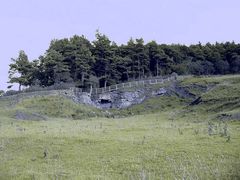
The quarry at Downhill which has obliterated any trace of the milecastle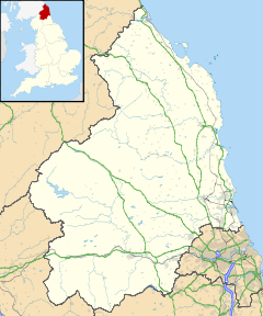
 Milecastle 21
 Milecastle 21 shown within Northumberland
OS grid reference NZ00436851 List of places: UK • England • Northumberland 
This article is part of the series on:
Military of ancient Rome (portal)
753 BC – AD 476Structural history Roman army (unit types and ranks, legions, auxiliaries, generals) Roman navy (fleets, admirals) Campaign history Lists of wars and battles Decorations and punishments Technological history Military engineering (castra, siege engines, arches, roads) Political history Strategy and tactics Infantry tactics Frontiers and fortifications (limes, Hadrian's Wall) Milecastle 21 (Down Hill) was a milecastle of the Roman Hadrian's Wall. The site was identified by measurement only, as the milecastle's remains have been totally removed. This is probably due to extensive quarrying at the site, which now lies under pasture (and partly beneath the Military Road).[1]
Contents
Construction
No details of the Milecastle's construction have been identified.
Excavations and investigations
- 1966 - English Heritage Field Investigation. It was noted that there were no visible remains, and that the area was greatly disturbed by quarry tracks and spoil.[1]
- 1989 - English Heritage Field Investigation. It was again noted that there were no visible remains, and the probable location was restated.[1]
Associated Turrets
Each milecastle on Hadrian's Wall had two associated turret structures. These turrets were positioned approximately one-third and two-thirds of a Roman mile to the west of the Milecastle, and would probably have been manned by part of the milecastle's garrison. The turrets associated with Milecastle 21 are known as Turret 21A and Turret 21B.
Turret 21A
Turret 21A (Red House) is probably located 73 metres (80 yd) to the east of the east wall of Onnum, though some doubt has been expressed by an English Heritage field investigation.[2] Its remains lie under the modern road.[3]
Location on Ordnance Survey 1:25 000 map: 55°00′39″N 2°00′11″W / 55.010895°N 2.003081°W
Turret 21B
Turret 21B (Fence Burn) is probably located partly beneath the military road, though the exact location has been speculated due to the presence of a small mound[3] along with dark soil and pottery discovered in 1930.[4][5]
Location on Ordnance Survey 1:25 000 map: 54°59′37″N 1°44′12″W / 54.993672°N 1.736733°W
Monument Records
Monument Monument Number National Monuments Record Number Milecastle 21 20473 NZ 06 NW 10 Turret 21A 18154 NY 96 NE 1 Turret 21B 18160 NY 96 NE 3 References
- ^ a b c "Milecastle 21". Pastscape. English Heritage. http://www.pastscape.org/hob.aspx?hob_id=20473. Retrieved 3 Aug 2010.
- ^ "Turret 21A". Pastscape. English Heritage. http://www.pastscape.org/hob.aspx?hob_id=18154. Retrieved 3 Aug 2010.
- ^ a b Breeze, David J (1934), Handbook to the Roman Wall (14th Revised edition - Nov 2006), Society of Antiquaries of Newcastle upon Tyne, pp. 183, ISBN 0901082651
- ^ Birley, Eric B (1961), Research on Hadrian's Wall, Titus Wilson & Son, pp. 73,171
- ^ "Turret 21B". Pastscape. English Heritage. http://www.pastscape.org/hob.aspx?hob_id=18160. Retrieved 3 Aug 2010.
Bibliography
- Daniels, Charles (1979), "Review: Fact and Theory on Hadrian's Wall", Britannia 10: 357–364, JSTOR 526069
External links
 Media related to Milecastle 21 at Wikimedia Commons
Milecastles of Hadrian's Wall Milecastles 0 • 1 • 2 • 3 • 4 • 5 • 6 • 7 • 8 • 9 • 10 • 11 • 12 • 13 • 14 • 15 • 16 • 17 • 18 • 19 • 20 • 21 • 22 • 23 • 24 • 25 • 26 • 27 • 28 • 29 • 30 • 31 • 32 • 33 • 34 • 35 • 36 • 37 • 38 • 39 • 40 • 41 • 42 • 43 • 44 • 45 • 46 • 47 • 48 • 49 • 50 • 50TW • 51 • 52 • 53 • 54 • 55 • 56 • 57 • 58 • 59 • 60 • 61 • 62 • 63 • 64 • 65 • 66 • 67 • 68 • 69 • 70 • 71 • 72 • 73 • 74 • 75 • 76 • 77 • 78 • 79 • 80
Milefortlets MF 1 • MF 2 • MF 3 • MF 4 • MF 5 • MF 6 • MF 7 • MF 8 • MF 9 • MF 10 • MF 11 • MF 12 • MF 13 • MF 14 • MF 15 • MF 16 • MF 17 • MF 18 • MF 19 • MF 20 • MF 21 • MF 22 • MF 23 • MF 24 • MF 25 • MF 26Other structures on Hadrian's Wall Portgate • Chesters Bridge • Knag Burn Gateway • Peel Gap Tower • Willowford Bridge • Pike Hill Signal TowerCategories:- Milecastles of Hadrian's Wall


Wikimedia Foundation. 2010.