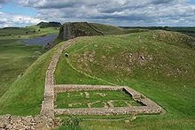
- Milecastle 39
-

This article is part of the series on:
Military of ancient Rome (portal)
753 BC – AD 476Structural history Roman army (unit types and ranks, legions, auxiliaries, generals) Roman navy (fleets, admirals) Campaign history Lists of wars and battles Decorations and punishments Technological history Military engineering (castra, siege engines, arches, roads) Political history Strategy and tactics Infantry tactics Frontiers and fortifications (limes, Hadrian's Wall) Milecastle 39, also known as Castle Nick, is a Roman fortification along Hadrian's Wall.
Milecastle 39 was partly excavated by archaeologists in the 19th century, and more fully in the 1980s by conservation workers. The milecastle measures 19m long by 15.5m across with stone walls standing 1.75m high. The excavations in the mid-1980s[1] revealed that barracks blocks that were initially built inside the milecastle had later been replaced by small individual buildings. The milecastle was occupied continuously until the fourth century AD.
References
- ^ Photographs and commentary from the dig during the mid-1980s that revealed the milecastle as it is seen today can be found at http://www.twoatlarge.com/ralph/archaeology/newarch/hadrianswall-1.html
External links
 Media related to Milecastle 39 at Wikimedia Commons
Milecastles of Hadrian's Wall Milecastles 0 • 1 • 2 • 3 • 4 • 5 • 6 • 7 • 8 • 9 • 10 • 11 • 12 • 13 • 14 • 15 • 16 • 17 • 18 • 19 • 20 • 21 • 22 • 23 • 24 • 25 • 26 • 27 • 28 • 29 • 30 • 31 • 32 • 33 • 34 • 35 • 36 • 37 • 38 • 39 • 40 • 41 • 42 • 43 • 44 • 45 • 46 • 47 • 48 • 49 • 50 • 50TW • 51 • 52 • 53 • 54 • 55 • 56 • 57 • 58 • 59 • 60 • 61 • 62 • 63 • 64 • 65 • 66 • 67 • 68 • 69 • 70 • 71 • 72 • 73 • 74 • 75 • 76 • 77 • 78 • 79 • 80Milefortlets MF 1 • MF 2 • MF 3 • MF 4 • MF 5 • MF 6 • MF 7 • MF 8 • MF 9 • MF 10 • MF 11 • MF 12 • MF 13 • MF 14 • MF 15 • MF 16 • MF 17 • MF 18 • MF 19 • MF 20 • MF 21 • MF 22 • MF 23 • MF 24 • MF 25 • MF 26Other structures on Hadrian's Wall Portgate • Chesters Bridge • Knag Burn Gateway • Peel Gap Tower • Willowford Bridge • Pike Hill Signal Tower
This article relating to archaeology in the United Kingdom is a stub. You can help Wikipedia by expanding it. This Ancient Rome-related article is a stub. You can help Wikipedia by expanding it. This article about a Cumbria building or structure is a stub. You can help Wikipedia by expanding it. Categories:- United Kingdom archaeology stubs
- Ancient Rome stubs
- Cumbria building and structure stubs
- Milecastles of Hadrian's Wall
Wikimedia Foundation. 2010.
Look at other dictionaries:
Milecastle 52 — (Bankshead), one of the milecastles on Hadrian s Wall, is situated to the west of Birdoswald fort (OS grid reference NY 579 649). Although not now visible, excavation showed that it measures 27.5m east to west by 23.4m north to south and that it… … Wikipedia
Milecastle 18 — is one of the milecastle forts along Hadrian s Wall, in northern England.[1] Excavations slightly to the west of the milecasle toward a farm have revealed the presence of cobbles and sandstone, giving likely evidence of an ancient roadway… … Wikipedia
Milecastle 53 — (Banks Burn), one of the milecastles on Hadrian s Wall, is situated west of the hamlet of Banks, Cumbria and northeast of Lanercost Priory (grid reference NY564646). It lies 1520m west of Milecastle 52 and 1436m east of Milecastle 54. It measures … Wikipedia
Milecastle 20 — is thought to lie beneath these houses in the hamlet of Halton Shields … Wikipedia
Milecastle 42 — Milecastle 42 … Wikipedia
Milecastle 17 — Coordinates: 55°00′31″N 1°54′11″W / 55.00850°N 1.90303°W / 55.00850; 1.90303 … Wikipedia
Milecastle 9 — Coordinates: 54°59′27″N 1°43′20″W / 54.990701°N 1.722327°W / 54.990701; 1.722327 … Wikipedia
Milecastle 1 — Coordinates: 54°59′01″N 1°33′02″W / 54.983494°N 1.550492°W / 54.983494; 1.550492 … Wikipedia
Milecastle 23 — Coordinates: 55°00′54″N 2°02′25″W / 55.014932°N 2.040394°W / 55.014932; 2.040394 … Wikipedia
Milecastle 2 — Coordinates: 54°58′44″N 1°34′10″W / 54.978979°N 1.569447°W / 54.978979; 1.569447 … Wikipedia
Milecastle 10 — Coordinates: 54°59′43″N 1°44′38″W / 54.995197°N 1.744027°W / 54.995197; 1.744027 … Wikipedia


