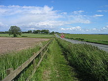
Military Road (Northumberland)

Military Road (Northumberland)
B6318, Near Harlow Hill

The Military Road is a name given locally to part of the B6318 road in Northumberland, England, which runs from Heddon-on-the-Wall (54°59′51″N 1°47′34″W / 54.9974°N 1.7929°W / 54.9974; -1.7929 (Military Road (eastern end))) in the east to Greenhead (54°58′55″N 2°32′04″W / 54.9820°N 2.5344°W / 54.9820; -2.5344 (Military Road (western end))) in the west.

For much of its length the road is straight and displays the characteristics of a Roman road. However the term "military road" comes from the building of the road by Hanoverian forces in 1746 in order to suppress the Jacobites to the North.

The main feature of the road is that it runs alongside Hadrian's Wall for much of its length, and some parts of the road are built on the foundations of the wall.

History

The construction of the historical Military Road, on which the B6318 partially runs, is credited as one of the most damaging single operations to Hadrian's Wall in recorded history. General George Wade began construction of the road in 1746, in the wake of the latest Jacobite Risings, in which Bonny Prince Charlie had avoided his forces in Newcastle and been able to attack Carlisle in the west.

In light of this, the road was considered a matter of urgency, as Wade was anxious to move troops from Newcastle to Dumfriesshire and there was no route with which to efficiently transfer military forces. Much of the material from the wall (primarily Limestone and Sandstone) was salvaged and used for hardcore in its construction.

The topography west of Sewingshields made it necessary for the road to diverge from the wall, thus preserving what remains today.

General Wade was also responsible for a series of highways in Scotland. These include roads at Corrieyairack Pass and Aberfeldy.

See also

References

  • Smith, GH, Excavations near Hadrian's Wall at Tarraby Lane 1976, Britannia, Vol. 9 (1978), pp 19–56

Coordinates: 55°02′18″N 2°11′41″W / 55.0383°N 2.1948°W / 55.0383; -2.1948


Wikimedia Foundation. 2010.

Игры ⚽ Поможем решить контрольную работу

Look at other dictionaries:

  • Military Road — may refer to a road in any of the following locations. Contents 1 Australia 2 Georgia 3 India 4 Ireland 5 …   Wikipedia

  • Military Way (Hadrian's Wall) — For the Military Way associated with the Antonine Wall, see Antonine Wall. The Military Way is a modern name given to the Roman road constructed immediately to the south of Hadrian s Wall. It should not be confused with the nearby Military Road.… …   Wikipedia

  • Northumberland Hussars — Badge of the Northumberland Hussars Active 1794–present Country …   Wikipedia

  • Royal Northumberland Fusiliers — Northumberland Fusiliers Badge of the Northumberland Fusiliers Active 1674–1968 Country …   Wikipedia

  • Blyth, Northumberland — Coordinates …   Wikipedia

  • Warkworth, Northumberland — Warkworth is a village in Northumberland, England. It is probably best known for its well preserved medieval castle, church and hermitage. At the time of the 2001 census, the population of Warkworth was 1,600. GeographyWarkworth is situated in a… …   Wikipedia

  • Once Brewed — Coordinates: 55°00′04″N 2°23′06″W / 55.001°N 2.385°W / 55.001; 2.385 …   Wikipedia

  • Devil's Causeway — Coordinates: 55°18′29″N 1°48′32″W / 55.308°N 1.809°W / 55.308; 1.809 …   Wikipedia

  • Hadrian's Wall — This article is about the fortification in Northern England. For the Broad Wall of Jerusalem, see Broad Wall (Jerusalem). Coordinates: 55°01′27″N 2°17′33″W / 55.02417°N 2 …   Wikipedia

  • Chesters Bridge — For the bridge across the Mississippi, see Chester Bridge. Coordinates: 55°01′30″N 2°08′17″W / 55.025°N 2.138°W / 55.025; 2.138 …   Wikipedia

Share the article and excerpts

Direct link
Do a right-click on the link above
and select “Copy Link”