Middleton, Perth and Kinross

Middleton, Perth and Kinross

Coordinates: 56°14′41″N 3°25′00″W / 56.244703°N 3.416732°W / 56.244703; -3.416732

Middleton
Middleton is located in Perth and Kinross
Middleton

 Middleton shown within Perth and Kinross
OS grid reference NO123067
Council area Perth and Kinross
Lieutenancy area Perth and Kinross
Country Scotland
Sovereign state United Kingdom
Post town KINROSS
Postcode district KY13
Dialling code 01577
Police Tayside
Fire Tayside
Ambulance Scottish
EU Parliament Scotland
UK Parliament Ochil and South Perthshire
Scottish Parliament Ochil
List of places: UK • Scotland •

Middleton is a hamlet and farmstead in Perth and Kinross, Scotland. It lies approximately 3 miles north of Kinross,to the west of the M90 motorway.[1]

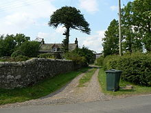
Village street in Middleton

References

  1. ^ "Perth & Alloa", Ordnance Survey Landranger Map, 2007, ISBN 0319229971 

Wikimedia Foundation. 2010.

Игры ⚽ Поможем сделать НИР

Look at other dictionaries:

  • Perth and Kinross — This article is about the Scottish local government area. For the former UK Parliamentary constituency abolished in 1997, see Perth and Kinross (UK Parliament constituency). Perth and Kinross Pairth an Kinross Peairt agus Ceann Rois Location …   Wikipedia

  • Methven, Perth and Kinross — Coordinates: 56°24′54″N 3°34′48″W / 56.415°N 3.580°W / 56.415; 3.580 …   Wikipedia

  • Cottown, Perth and Kinross — Coordinates: 56°22′35″N 3°17′02″W / 56.376436°N 3.283979°W / 56.376436; 3.283979 …   Wikipedia

  • Craigie, Perth and Kinross — Coordinates: 56°34′30″N 3°26′20″W / 56.575102°N 3.438833°W / 56.575102; 3.438833 …   Wikipedia

  • Dull, Perth and Kinross — Coordinates: 56°37′07″N 3°56′50″W / 56.618498°N 3.947334°W / 56.618498; 3.947334 …   Wikipedia

  • Perth, Scotland — Coordinates: 56°23′49″N 3°26′14″W / 56.396911°N 3.437262°W / 56.396911; 3.437262 …   Wikipedia

  • List of historic buildings and architects of the United Kingdom — The Historic buildings of the United Kingdom date from the stone age to the twenty first century AD, and tell the story of the architecture of the United Kingdom.See also: List of British architects Pre Historic buildings structures Roman… …   Wikipedia

  • Scone, Scotland — For other uses, see Scone (disambiguation). Coordinates: 56°25′04″N 3°24′15″W / 56.417903°N 3.404037°W / 56.417903; 3.404037 …   Wikipedia

  • Crieff — Coordinates: 56°22′32″N 3°50′33″W / 56.37568°N 3.84262°W / 56.37568; 3.84262 …   Wikipedia

  • Coupar Angus — Coordinates: 56°32′47″N 3°16′01″W / 56.546425°N 3.266958°W / 56.546425; 3.266958 …   Wikipedia

Share the article and excerpts

Direct link
Do a right-click on the link above
and select “Copy Link”